Castel di Sangro
Castel di Sangro (locally Caštiéllë) is a city and comune of 6,461 people (as of 2013) in the Province of L'Aquila, in Abruzzo, Central Italy. It is the main city of the Alto Sangro e Altopiano delle Cinque Miglia area.
Castel di Sangro | |
|---|---|
| Comune di Castel di Sangro | |
 Valley of Castel di Sangro | |
Location of Castel di Sangro 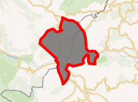
| |
 Castel di Sangro Location of Castel di Sangro in Italy 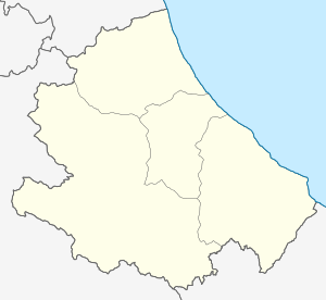 Castel di Sangro Castel di Sangro (Abruzzo) | |
| Coordinates: 41°47′00″N 14°6′00″E | |
| Country | Italy |
| Region | Abruzzo |
| Province | L'Aquila (AQ) |
| Frazioni | Roccacinquemiglia, Località Pontone, Località Sant'Angelo |
| Government | |
| • Mayor | Umberto Murolo (PDL)[1] |
| Area | |
| • Total | 83.98 km2 (32.42 sq mi) |
| Elevation | 805 m (2,641 ft) |
| Population (2013)[3] | |
| • Total | 6,461 |
| • Density | 77/km2 (200/sq mi) |
| Demonym(s) | Castellani |
| Time zone | UTC+1 (CET) |
| • Summer (DST) | UTC+2 (CEST) |
| Postal code | 67031 |
| Dialing code | 0864 |
| Patron saint | San Rufo |
| Saint day | 27 August |
| Website | Official website |
Geography
Castel di Sangro is located near the Sangro River, in a valley in the Apennine Mountains.
Neighbouring towns include Roccaraso, Pescocostanzo, Rivisondoli, San Pietro Avellana and Montenero Val Cocchiara.
History
Castel di Sangro was known to the Romans as Aufidena[4] (a city of the Samnites). It is the ancestral home of the third and last line of the House of Caesar (Catulus Caesar).
Main sights
- Basilica di S. Maria Assunta
- Museo civico aufidenate
Sport
The town gained some popularity in the mid-1990s thanks to the exploits of local football club Castel di Sangro Calcio In 1996, Castel di Sangro was visited by American author Joe McGinniss who wrote The Miracle of Castel di Sangro, a book about the team that made it up through 5 leagues to get to Serie B, the second-highest league in Italian football. The club now plays at Abruzzo's Promozione level, five levels below Serie B.
Districts
Castel di Sangro is divided into six districts:
- Civita
- Stazione
- Colle
- Codacchiola
- Ara
- Piazza
Transportation
Castel di Sangro has for years been a transit point for many people, because of its location making it the gateway into Abruzzo.
Roads
.jpg)
The main roads are:
- The Sangro Valley road, a highway connecting Castel di Sangro with the Val di Sangro, and then with the Adriatic Sea. The same road continues for a long stretch southward and is used by thousands of tourists who come from areas of Campania and other regions of southern Italy.
- The SS 17, a fast road connecting L'Aquila to Foggia. This road is very busy, with both local and through traffic. Its true capacity is often exceeded and it has seen a large number of accidents, some fatal. It is, however, generally well-managed, remaining open throughout the winter, despite the high altitude of the route.
- The Isernia - Castel di Sangro highway. Completed in 2011, this road halved the driving time from the Alto Molise to the Alto Sangro.[5]
References
- http://castel-di-sangro.corriere.it/rappresentanti/umberto-murolo.shtml?id=247585&refresh_ce-cp
- "Superficie di Comuni Province e Regioni italiane al 9 ottobre 2011". Istat. Retrieved 16 March 2019.
- "Popolazione Residente al 1° Gennaio 2018". Istat. Retrieved 16 March 2019.
- Lewis, Charlton T. "Aufĭdēna". A Latin Dictionary. Oxford: Clarendon Press. Retrieved 9 March 2012.
- Passera, Corrado. "Apre l'ultimo tratto di superstrada Molise raggiungibile in 15 minuti". Retrieved 20 December 2014.
- Kentville and Castel di Sangro Twinning - Official video, retrieved 2019-09-08
- Duke, Laura Churchill. "Kentville twins with Italian town Castel di Sangro | The Register/Advertiser". www.kingscountynews.ca. Retrieved 2019-09-08.
External links
- Official website (in Italian and English)
- Castel di Sangro 1 Scout Group official website
| Authority control |
|
|---|