Canton of Basel-Landschaft
The canton of Basel-Landschaft (German: ![]()
Kanton Basel-Landschaft | |
|---|---|
 Coat of arms | |
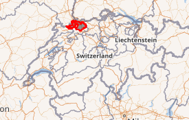
Location in Switzerland
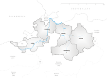
Map of Basel-Landschaft 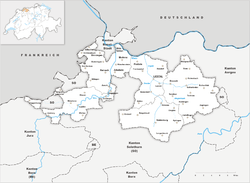 | |
| Coordinates: 47°7′N 7°44′E | |
| Capital | Liestal |
| Largest city | Allschwil |
| Subdivisions | 86 municipalities, 5 districts |
| Government | |
| • Executive | Regierungsrat (5) |
| • Legislative | Landrat (90) |
| Area | |
| • Total | 517.67 km2 (199.87 sq mi) |
| Population (March 2019)[2] | |
| • Total | 289,527 |
| • Density | 560/km2 (1,400/sq mi) |
| ISO 3166 code | CH-BL |
| Highest point | 1,169 m (3,835 ft): Hinteri Egg |
| Lowest point | 246 m (807 ft): confluence of the river Birs with the Rhine, at Birsfelden |
| Joined | 1501 |
| Languages | German |
| Website | www |
History
Basel-Landschaft, together with Basel-Stadt, formed the historic Canton of Basel until they separated following the uprising of 1833 (Battle of the Hülftenschanz near Frenkendorf).
In Roman times, the area of Basel was a centre of Roman activity. There are well-preserved remains at the site of Augusta Raurica in the canton of Basel-Landschaft. Around 200 AD there were about 20,000 people living in this city, now part of the much smaller Augst. The remains are on display in an open-air museum. The museum attracts over 140,000 visitors per year. Many of these visitors are schoolchildren from other parts of Switzerland. The site of Augusta Raurica includes the best-preserved amphitheatre north of the Alps, and a reconstructed Roman villa.
The lands of the canton Basel-Landschaft are part of the lands acquired by the city of Basel. Until the end of the 16th century, most of the canton's land belonged to the city of Basel. After Napoleon's visit in 1798, the country achieved equality with the city. The country was economically dependent on the city, most probably because of the cost and difficulty in transporting agricultural goods to further markets, the financing of land transactions and crop production by city-based merchants. Low levels of education and literacy in the agricultural areas of Europe was typical in that era. The best students would be sponsored and sent away for higher learning. The city of Basel remained the cultural and economic centre of both Basel half cantons until then. Castles and residences of Basel merchants dominated much of the landscape in Basel-Landschaft.

After 1830 there were political quarrels and armed conflict in the canton of Basel. Some of these were concerned with the rights of the population in the agricultural areas. They ultimately led to the separation of the canton Basel-Landschaft from the city of Basel on 26 August 1833. Since then, there has been a movement for reunification. This movement gained momentum after 1900 when many parts of Basel-Landschaft became industrialized. The two half cantons agreed in principle to merge, but in 1969 the people of Basel-Landschaft voted down a referendum on this proposal in favour of retaining their independence. It is thought that the closing economic gap between the two cantons was the main reason why the population changed their attitude.
That vote was not the end of a close relationship between the two Basels. The two half cantons have since signed a number of agreements to co-operate. The contribution of Basel-Landschaft to the University of Basel since 1976 is just one example.
Geography
The canton of Basel-Landschaft lies in the northwestern corner of Switzerland just south of the canton of Basel-Stadt.
With a few exceptions, it includes the towns of the Laufental along the river Birs, the Birseck and the Leimental, as well as the towns along the Ergolz and its tributaries. The shape of the canton is very irregular, and its borders cut across several towns.
In terms of size, it is one of the smaller cantons of Switzerland (18th of 26). However, it is number 10 in terms of population.
Basel-Landschaft borders on the east and north with the canton of Aargau and the Rhine, which forms the border with Germany. On the northwest, it borders with France
On the south, it borders on the canton of Solothurn, with a few exclaves of that canton within its western area. In the extreme southwest, it borders on the canton of Jura.
The Jura mountain chain traverses the canton. The rivers Ergolz and Birs drain the lands of the canton.
The thirty rivers of Baselland are:
|
|
|
Politics
Since the decision to remain independent from Basel-Stadt in 1969 there have been a number of requests in the parliament for Basel-Landschaft to become a full canton. In 1988 the canton of Basel-Landschaft had this aim written into its constitution. The aim remains to change the Swiss constitution to recognize the two cantons of Basel as full members.
Federal election results
| Percentage of the total vote per party in the canton in the Federal Elections 1971-2015[3] | ||||||||||||||
|---|---|---|---|---|---|---|---|---|---|---|---|---|---|---|
| Party | Ideology | 1971 | 1975 | 1979 | 1983 | 1987 | 1991 | 1995 | 1999 | 2003 | 2007 | 2011 | 2015 | |
| FDP.The Liberalsa | Classical liberalism | 23.0 | 23.9 | 26.7 | 25.1 | 22.0 | 24.8 | 19.6 | 22.1 | 19.9 | 17.0 | 11.5 | 15.8 | |
| CVP/PDC/PPD/PCD | Christian democracy | 13.3 | 13.3 | 11.5 | 10.8 | 12.3 | 11.6 | 11.7 | 12.0 | 10.0 | 11.4 | 8.2 | 9.1 | |
| SP/PS | Social democracy | 28.2 | 30.3 | 31.4 | 32.5 | 22.8 | 24.4 | 25.3 | 23.3 | 24.7 | 25.2 | 24.4 | 22.2 | |
| SVP/UDC | Swiss nationalism | 11.8 | 10.7 | 10.6 | 11.2 | 12.0 | 12.3 | 10.8 | 18.0 | 26.5 | 28.5 | 26.9 | 29.8 | |
| Ring of Independents | Social liberalism | 13.8 | 11.2 | 7.8 | 4.4 | 2.7 | * b | 1.3 | * | * | * | * | * | |
| EVP/PEV | Christian democracy | * | * | 3.9 | * | 3.2 | 2.6 | 1.7 | 2.4 | 2.7 | 2.8 | 3.3 | 2.2 | |
| GLP/PVL | Green liberalism | * | * | * | * | * | * | * | * | * | * | 5.0 | 2.7 | |
| BDP/PBD | Conservatism | * | * | * | * | * | * | * | * | * | * | 6.4 | 2.8 | |
| PdA/PST-POP/PC/PSL | Socialism | * | 1.8 | 1.0 | * | * | * | * | * | * | * | * | * | |
| POCH | Progressivism | * | 3.3 | 7.1 | 7.2 | 7.4 | c | * | * | * | * | * | * | |
| GPS/PES | Green politics | * | * | * | 1.9 | 6.9 | 11.0 | 9.5 | 9.2 | 12.6 | 13.8 | 13.6 | 14.2 | |
| FGA | Feminist | * | * | * | 3.0 | 2.0 | c | * | * | * | * | * | * | |
| SD/DS | National conservatism | 10.0 | 5.6 | * | 3.9 | 6.2 | 9.1 | 11.0 | 10.1 | 2.7 | 0.8 | 0.7 | * | |
| EDU/UDF | Christian right | * | * | * | * | * | * | 0.6 | * | * | 0.5 | * | 0.4 | |
| FPS/PSL | Right-wing populism | * | * | * | * | 2.6 | 4.3 | 1.3 | 0.3 | 0.2 | * | * | * | |
| Other | * | * | * | * | * | * | 7.1 | 2.5 | 0.8 | * | * | 0.8 | ||
| Voter participation % | 51.8 | 48.3 | 43.0 | 49.3 | 46.8 | 44.5 | 41.3 | 41.8 | 44.2 | 49.3 | 48.2 | 46.8 | ||
Political subdivisions
The nine municipalities of the Arlesheim district used to belong to the diocese of Basel. In 1792 French troops occupied the district and in 1793 the lands were annexed by France, which explains the linguistic switch of the Family of the House of Basel's name from "von Basel" to "de Bâle", since Arlesheim holds their manor. In 1815 at the Congress of Vienna the district joined Basel.
The district of Laufental has the same history as that of Arlesheim. The important difference is that in 1815 Laufental joined Bern rather than Basel. When the canton of Jura was created in 1979, the district of Laufental became an enclave of the canton of Bern. It was allowed self- determination and in 1980 the people decided to join the canton of Basel-Landschaft. This led to Laufental joining the canton of Basel-Landschaft on 1 January 1994 after a lengthy administrative process.
Districts
There are 5 areas (Bezirke) in Basel-Landschaft (as of 2019):
- Arlesheim (Pop: 156,591 ) capital: Arlesheim (Pop: 9,111)
- Laufen (Pop: 20,071) capital: Laufen (Pop: 5,685)
- Liestal (Pop: 60,954) capital: Liestal (Pop: 14,415)
- Sissach (Pop: 35,912) capital: Sissach (Pop: 6,702)
- Waldenburg (Pop: 15,999) capital: Waldenburg (Pop: 1,089)
Municipalities
There are 86 municipalities in the canton (As of 2009).[4]
Demographics
The population is predominantly German-speaking. Protestantism is the main religion in the canton (43% as of 2000), while about one-third of the population (32%) is Roman Catholic.[5] The Swiss Reformed Church and Christian Catholic Church of Switzerland are recognized as state churches. Between 1959 and 1970 the canton was Switzerland's fastest-growing, as the population almost doubled from 108,000 to 205,000. Today, the canton has a population (as of 31 March 2017) of 289,527.[2] As of 2007, the population included 48,719 foreigners who made up 18.1% of the population.[6]
Economy
Agriculture in the canton includes fruit growing, dairy farming and cattle breeding. Important industries include textiles, metals and chemicals.
The canton of Basel-Landschaft is part of the economic region around Basel that includes parts of France and Germany as well as both half cantons of Basel. Since the 1960s there are agreements in force to strengthen contacts within the so-called Regio Basiliensis. This economic co-operation is often considered as the most intensive in Europe.
From the 17th century until the beginning of the 20th century silk weaving was important in Basel-Landschaft. Factories were established as early as 1850, following the finding of salt in underground deposits, founding industries such as the chemical industry in Schweizerhalle. The chemical industry means that Basel is one of the richer parts of Switzerland.
The chemical industry is not the sole employer in the canton. Small and middle-sized businesses make up about a quarter of the cantonal economy. Many of these, however, are connected to the larger employers.
See also
- Augusta Raurica
- List of castles and fortresses in Switzerland
- Basellandschaftliche Zeitung, daily newspaper published in Liestal.
Notes and references
- Arealstatistik Land Cover - Kantone und Grossregionen nach 6 Hauptbereichen accessed 27 October 2017
- Canton of Basel-Land Statistics, Wohnbevölkerung nach Nationalität und Konfession per 31. März 2019 (in German) accessed 23 September 2019
- Nationalratswahlen: Stärke der Parteien nach Kantonen (Schweiz = 100%) (Report). Swiss Federal Statistical Office. 2015. Archived from the original on 2016-08-02. Retrieved 2016-08-04.
- "Liste officielle des communes de la Suisse - 01.01.2008". Office fédéral de la statistique. Archived from the original on 12 June 2009. Retrieved 15 December 2008.
- Federal Department of Statistics (2004). "Wohnbevölkerung nach Religion". Archived from the original (Interactive Map) on 2008-12-29. Retrieved 2009-01-15.
- Federal Department of Statistics (2008). "Ständige Wohnbevölkerung nach Staatsangehörigkeit, Geschlecht und Kantonen". Archived from the original (Microsoft Excel) on 2008-12-15. Retrieved November 5, 2008.
External links
| Wikimedia Commons has media related to Canton of Basel-Landschaft. |
- Official website

- Official statistics
- Canton of Basel-Landschaft in German, French and Italian in the online Historical Dictionary of Switzerland.
|
| Authority control |
|
|---|