Camposanto
Camposanto (Modenese: Campsànt; Mirandolese: Campsènt) is a comune (municipality) in the Province of Modena in the Italian region Emilia-Romagna, located about 35 kilometres (22 mi) northwest of Bologna and about 20 kilometres (12 mi) northeast of Modena on the Panaro river. Although the name in Italian literally means "saint's field", which normally means "cemetery" in Italian, its original (Latin) name, "Campus Sanctus", probably honoured the 14th century Ferrara family of Santi, who owned the land.
Camposanto | |
|---|---|
| Comune di Camposanto | |
 | |
Location of Camposanto 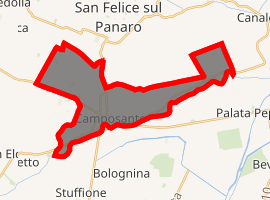
| |
 Camposanto Location of Camposanto in Italy 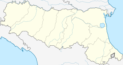 Camposanto Camposanto (Emilia-Romagna) | |
| Coordinates: 44°47′N 11°8′E | |
| Country | Italy |
| Region | Emilia-Romagna |
| Province | Modena (MO) |
| Government | |
| • Mayor | Monja Zaniboni |
| Area | |
| • Total | 22.71 km2 (8.77 sq mi) |
| Elevation | 21 m (69 ft) |
| Population (30 April 2017)[2] | |
| • Total | 3,181 |
| • Density | 140/km2 (360/sq mi) |
| Demonym(s) | Camposantesi |
| Time zone | UTC+1 (CET) |
| • Summer (DST) | UTC+2 (CEST) |
| Postal code | 41031 |
| Dialing code | 0535 |
| Website | Official website |
The Battle of Campo Santo was fought here in 1743.
Camposanto borders the following municipalities: Bomporto, Crevalcore, Finale Emilia, Medolla, Ravarino, San Felice sul Panaro, San Prospero.
In May 2012 Camposanto was the epicenter of a 6.0-magnitude earthquake.
References
- "Superficie di Comuni Province e Regioni italiane al 9 ottobre 2011". Istat. Retrieved 16 March 2019.
- All demographics and other statistics: Italian statistical institute Istat.
External links