California State Route 24
State Route 24 (SR 24) is a heavily traveled east–west state highway in the U.S. state of California that serves the eastern side of the San Francisco Bay Area. A freeway throughout its entire length, it runs from the Interstate 580/Interstate 980 interchange (just east of the MacArthur Maze) in Oakland, and through the Caldecott Tunnel under the Oakland Hills, to the Interstate 680 junction in Walnut Creek. It lies in Alameda County, where it is highly urban, and Contra Costa County, where it passes through wooded hillsides and suburbs. SR 24 is a major connection between the San Francisco–Oakland Bay Bridge/MacArthur Maze complex and the inland cities of the East Bay.
| ||||
|---|---|---|---|---|
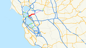 SR 24 highlighted in red | ||||
| Route information | ||||
| Defined by Streets and Highways Code § 324 | ||||
| Maintained by Caltrans | ||||
| Length | 13.492 mi[1] (21.713 km) | |||
| Existed | 1934[2]–present | |||
| Tourist routes | ||||
| Restrictions | Trucks carrying hazardous material are only permitted through the Caldecott Tunnel between 3:00 a.m. and 5:00 a.m.[4] | |||
| Major junctions | ||||
| West end | ||||
| East end | ||||
| Location | ||||
| Counties | Alameda, Contra Costa | |||
| Highway system | ||||
| ||||

Route description
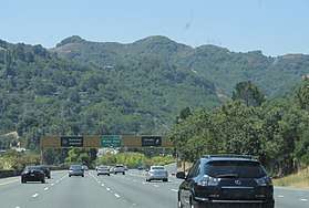
SR 24 begins at the four-level interchange with Interstate 580 and Interstate 980 in Oakland; this interchange is located on top of Grove Shafter Park. SR 24 initially heads north before turning east near the Berkeley city limits. Route 24 rises from near sea level in downtown Oakland past its interchange with State Route 13, which is a freeway south of SR 24 (upgraded August 1999) and a surface street north of SR 24. After this, SR 24 crosses the Contra Costa County county line through the four-bore Caldecott Tunnel and offers some attractive views of the hilly terrain through which it passes. Some protection of the views comes from the highway's designation as a California Scenic Highway.[5]
On the other side of the tunnel, SR 24 travels through unincorporated Contra Costa County before entering Orinda. SR 24 crosses the Mokelumne Aqueduct soon after entering the city of Lafayette. SR 24 terminates at the intersection with Interstate 680 just inside the city limits of Walnut Creek.[6]
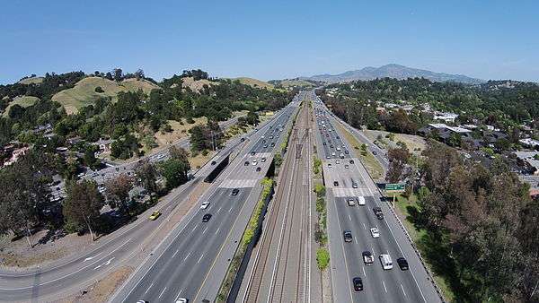
The Antioch–SFO/Millbrae line of the Bay Area Rapid Transit runs in the freeway's center median, excepting the vicinity of the Caldecott Tunnel and the approach to the interchange with Interstate 680.
SR 24 is part of the California Freeway and Expressway System,[7] and is part of the National Highway System,[8] a network of highways that are considered essential to the country's economy, defense, and mobility by the Federal Highway Administration.[9] SR 24 is eligible to be included in the State Scenic Highway System;[10] however, Caltrans has only designated it as a scenic highway between the eastern end of the Caldecott Tunnel and I-680,[11] meaning that it is a substantial section of highway passing through a "memorable landscape" with no "visual intrusions", where the potential designation has gained popular favor with the community.[12] SR 24 is designated as both the Grove Shafter Freeway, after streets the route travels along (Grove Street was later renamed Martin Luther King Jr. Way), and the William Byron Rumford Freeway, honoring the first African American elected to a state public office in Northern California,[13] from the Caldecott Tunnel to the I-580 interchange segment of the MacArthur Maze, continuing henceforth as I-980 to the terminus with I-880.[14]
History
Highway 24 was designated in 1932 in conjunction with the ongoing construction of the Broadway Low Level Tunnel (subsequently renamed the Caldecott Tunnel) which opened in 1937,[15] connecting with the new Eastshore Highway and the approaches to the new Bay Bridge by way of Tunnel Road and Ashby Avenue through Berkeley west of the Berkeley Hills, and routed along Mount Diablo Boulevard through Contra Costa County east of the hills. Before either the bridge or the tunnel were completed, Highway 24 was provisionally routed starting from downtown Oakland at the major intersection of San Pablo and Broadway, which was also the terminal point of US 40 and State Highway 17. From this point, Highway 24 proceeded northward along Broadway to College Avenue, then along College to Claremont Avenue, up Claremont to Tunnel Road, then up into the Berkeley Hills on Tunnel Road to the old Intercounty Tunnel (also called the Kennedy Tunnel), through the tunnel into Contra Costa County.[16]
Highway 24 remained along Ashby Avenue until completion of the Grove-Shafter Freeway in the late 1960s. This new freeway, which ran from the Caldecott Tunnel through downtown Oakland to the MacArthur and Nimitz Freeways, was designated Route 24 and Ashby was re-designated Route 13.
Route 24 used to extend much further east. The section of Interstate 680 between the current terminus of SR 24 and State Route 242 was dual-signed I-680 and SR 24 until ca. 1987; State Route 242 which runs primarily in Concord was signed as Route 24 until the same time. Older maps show routes for 24 which continue along State Route 4 from the current intersection of 242 to the Antioch Bridge, continuing along the river road to Sacramento, currently State Route 160, then continuing north to Woodland, Marysville, Oroville, along the North Fork of the Feather River to a junction with State Route 89 (this segment is currently State Route 70), where it continued dual-numbered with 89 through Quincy. Highway 24 split from 89 near Graeagle, and continued east through Portola east until its terminus at U.S. Route 395.[17] Parts of the same route were also sometimes designated as State Route 84.
At least one published map from the 1960s incorrectly showed Route 24 extending eastward from Interstate 680 in Walnut Creek to Route 4 in Pittsburg that followed the Ygnacio Valley Road-Kirker Pass Road-Railroad Avenue corridor, presumably as a future extension that never materialized.
Exit list
Mileage is measured from the route's original western terminus, now part of Interstate 980.
| County | Location | mi[18] | km | Exit[18] | Destinations | Notes |
|---|---|---|---|---|---|---|
| Alameda | Oakland | 2.35 | 3.78 | 2A | Continuation beyond I-580; I-980 exit 2B | |
| 2.35 | 3.78 | 2B | Westbound exit and eastbound entrance; west end of SR 24; I-580 exit 19C eastbound, 19D westbound | |||
| 2.35 | 3.78 | 2 | Martin Luther King Jr Way, 51st Street | Eastbound exit and westbound entrance | ||
| 3.06 | 4.92 | 3 | Telegraph Avenue | Westbound exit and eastbound entrance | ||
| 3.06 | 4.92 | 3 | Claremont Avenue | Eastbound exit and westbound entrance | ||
| 4.15 | 6.68 | 4A | College Avenue | Westbound exit only | ||
| 4.15 | 6.68 | 4B | Broadway | Signed as exit 4 eastbound | ||
| 5.12 | 8.24 | 5A | Signed as exit 5 eastbound; CA 13 exits 5B-C northbound | |||
| 5.12 | 8.24 | 5B | Exits only, no access from SR 13 south to SR 24; eastbound exit is via exit 4 | |||
| 6.24 | 10.04 | 6 | Tunnel Road | Signed as "Old Tunnel Road" eastbound | ||
| Berkeley Hills | Caldecott Tunnel | |||||
| Contra Costa | | 6.64 | 10.69 | 7A | Fish Ranch Road | |
| Orinda | 7.39 | 11.89 | 7B | Wilder Road | ||
| 8.50 | 13.68 | 9 | Orinda, Moraga (Camino Pablo) | |||
| 9.66 | 15.55 | 10 | St. Stephens Drive, Hidden Valley Road | |||
| Lafayette | 10.59 | 17.04 | 11 | Acalanes Road, Mount Diablo Boulevard, Upper Happy Valley Road | ||
| 12.46 | 20.05 | 12 | Oak Hill Road – Central Lafayette, Moraga | Signed as exit 13 westbound | ||
| 13.85 | 22.29 | 14 | Pleasant Hill Road, Mount Diablo Boulevard | |||
| Walnut Creek | 15.33 | 24.67 | 15A | Left eastbound exit and westbound entrance; I-680 exit 46 southbound | ||
| 15.33 | 24.67 | 15B | Eastbound exit and westbound entrance; east end of CA 24; I-680 exit 46A northbound | |||
| 1.000 mi = 1.609 km; 1.000 km = 0.621 mi | ||||||
See also

References
- California Department of Transportation. "State Truck Route List". Sacramento: California Department of Transportation. Archived from the original (XLS file) on June 30, 2015. Retrieved June 30, 2015.
- California Highways: State Route 24
- California Department of Transportation (August 2019). "Officially Designated State Scenic Highways and Historic Parkways" (XLSX). Sacramento: California Department of Transportation. Retrieved March 27, 2019.
- "Vehicle Code Section 31301 - Caldecott Tunnel Restriction". California Department of Motor Vehicles. Retrieved July 21, 2014.
- California Road Atlas and Driver's Guide (Map). Thomas Brothers. 2000. p. L,158,156.
- The Road Atlas (Map). Rand McNally. 2008. p. 13.
- "Article 2 of Chapter 2 of Division 1 of the California Streets and Highways Code". Sacramento: California Office of Legislative Counsel. Retrieved February 6, 2019.
- Federal Highway Administration (March 25, 2015). National Highway System: San Francisco, CA (PDF) (Map). Scale not given. Washington, DC: Federal Highway Administration. Retrieved October 18, 2017.
- Natzke, Stefan; Neathery, Mike & Adderly, Kevin (June 20, 2012). "What is the National Highway System?". National Highway System. Washington, DC: Federal Highway Administration. Retrieved July 1, 2012.
- "Article 2.5 of Chapter 2 of Division 1 of the California Streets & Highways Code". Sacramento: California Office of Legislative Counsel. Retrieved February 6, 2019.
- California Department of Transportation (August 2019). "Officially Designated State Scenic Highways and Historic Parkways" (XLSX). Sacramento: California Department of Transportation. Retrieved October 18, 2017.
- California Department of Transportation (2012). Scenic Highway Guidelines (PDF). Sacramento: California Department of Transportation. p. 5. Retrieved June 8, 2017.
- "Berkeley Statue Honors Quiet Pharmacist Who Fought To End Housing Discrimination". CBS SF Bay Area. 18 July 2016. Archived from the original on 10 Aug 2016. Retrieved 6 June 2019.
- California Department of Transportation; California State Transportation Agency (January 2015). 2014 Named Freeways, Highways, Structures and Other Appurtenances in California. Sacramento: California Department of Transportation. pp. 106, 244, 271. Archived from the original (PDF) on May 30, 2015. Retrieved May 30, 2015.
- CalTrans State Highway Routes Selected Information 1995, p.39
- 1936 Shell Oil Street Guide and Metropolitan Map of San Francisco and Bay Cities, H. M. Gousha Company.
- Road Map of North Central California (Map) (undated, before 1956 ed.). National Automobile Club. § Section 2.
- Warring, KS (April 2, 2008). "State Route 24 Freeway Interchanges" (PDF). California Numbered Exit Uniform System. California Department of Transportation. Retrieved September 1, 2014.
External links
| Wikimedia Commons has media related to California State Route 24. |