California State Route 151
State Route 151 (SR 151) is a state highway in the U.S. state of California. The route runs along Shasta Dam Boulevard in Shasta County from Shasta Dam to Interstate 5 near Shasta Lake City.
| ||||
|---|---|---|---|---|
| Shasta Dam Boulevard | ||||
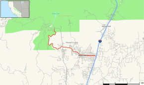 Map of Shasta County in northern California with SR 151 highlighted in red | ||||
| Route information | ||||
| Defined by Streets and Highways Code § 451 | ||||
| Maintained by Caltrans | ||||
| Length | 6.925 mi[1] (11.145 km) | |||
| Tourist routes | ||||
| Major junctions | ||||
| West end | ||||
| East end | ||||
| Location | ||||
| Counties | Shasta | |||
| Highway system | ||||
| ||||

Route description
SR 151 begins at Shasta Dam, where the Sacramento River is dammed to form Shasta Lake. From Shasta Dam, the road heads south as Shasta Dam Boulevard, crossing through heavily vegetated area. The road then meets CR A18 within the city of Shasta Lake. Heading eastward, the road enters the center of Shasta Lake before meeting its eastern terminus at Interstate 5.[3]
SR 151 is not part of the National Highway System,[4] a network of highways that are considered essential to the country's economy, defense, and mobility by the Federal Highway Administration.[5] SR 151 is eligible for the State Scenic Highway System,[6] and from Shasta Dam to Lake Boulevard is officially designated as a scenic highway by the California Department of Transportation,[7] meaning that it is a substantial section of highway passing through a "memorable landscape" with no "visual intrusions", where the potential designation has gained popular favor with the community.[8]
Major intersections
Except where prefixed with a letter, postmiles were measured on the road as it was in 1964, based on the alignment that existed at the time, and do not necessarily reflect current mileage. R reflects a realignment in the route since then, M indicates a second realignment, L refers an overlap due to a correction or change, and T indicates postmiles classified as temporary (for a full list of prefixes, see the list of postmile definitions).[1] Segments that remain unconstructed or have been relinquished to local control may be omitted. The entire route is in Shasta County.
| Location | Postmile [1][9][10] | Destinations | Notes | ||
|---|---|---|---|---|---|
| | 0.00 | Shasta Dam | West end of SR 151 | ||
| Shasta Lake | 3.78 | ||||
| 6.79 | Cascade Boulevard | ||||
| R6.92 | Interchange; east end of SR 151; I-5 exit 685 | ||||
| 1.000 mi = 1.609 km; 1.000 km = 0.621 mi | |||||
See also

References
- California Department of Transportation. "State Truck Route List". Sacramento: California Department of Transportation. Archived from the original (XLS file) on June 30, 2015. Retrieved June 30, 2015.
- California Department of Transportation (August 2019). "Officially Designated State Scenic Highways and Historic Parkways" (XLSX). Sacramento: California Department of Transportation. Retrieved March 27, 2019.
- Microsoft; Nokia (2011-01-26). "SR 151" (Map). Bing Maps. Microsoft. Retrieved 2011-01-26.
- Federal Highway Administration (March 25, 2015). National Highway System: California (North) (PDF) (Map). Scale not given. Washington, DC: Federal Highway Administration. Retrieved September 24, 2017.
- Natzke, Stefan; Neathery, Mike & Adderly, Kevin (June 20, 2012). "What is the National Highway System?". National Highway System. Washington, DC: Federal Highway Administration. Retrieved July 1, 2012.
- "Article 2.5 of Chapter 2 of Division 1 of the California Streets & Highways Code". Sacramento: California Office of Legislative Counsel. Retrieved February 6, 2019.
- California Department of Transportation (August 2019). "Officially Designated State Scenic Highways and Historic Parkways" (XLSX). Sacramento: California Department of Transportation. Retrieved September 24, 2017.
- California Department of Transportation (2012). Scenic Highway Guidelines (PDF). Sacramento: California Department of Transportation. p. 5. Retrieved June 8, 2017.
- California Department of Transportation (July 2007). "Log of Bridges on State Highways". Sacramento: California Department of Transportation.
- California Department of Transportation, All Traffic Volumes on CSHS, 2005 and 2006
External links
| Wikimedia Commons has media related to California State Route 151. |