Cal State LA station
Cal State LA (officially Cal State Los Angeles)[3] is a commuter train, bus rapid transit, and local bus station on the El Monte Busway transitway lanes of Interstate 10 (San Bernardino Freeway) at its namesake campus. It is located in the El Sereno neighborhood of the City of Los Angeles and Eastside region, in southern California. It began service as a bus station in 1973 and a train station in 1994.
Cal State LA | |||||||||||||||||||||
|---|---|---|---|---|---|---|---|---|---|---|---|---|---|---|---|---|---|---|---|---|---|
| Metrolink and LA Metro station | |||||||||||||||||||||
 Cal State LA Metro Silver Line westbound platform | |||||||||||||||||||||
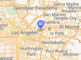
| Location | 5150 State University Drive Los Angeles, California, 90032 | ||||||||||||||||||||
| Coordinates | 34.0625°N 118.1702°W | ||||||||||||||||||||
| Owned by | California State University, Los Angeles Consortium | ||||||||||||||||||||
| Operated by | Metro | ||||||||||||||||||||
| Line(s) | SCRRA San Gabriel Subdivision[1] | ||||||||||||||||||||
| Platforms | 1 side platform (Metrolink), 2 side platforms (Metro Silver Line) | ||||||||||||||||||||
| Tracks | 4 | ||||||||||||||||||||
| Connections | Children's Court Shuttle, ACT Shuttle, Monterrey Park Spirit Park Bus | ||||||||||||||||||||
| Construction | |||||||||||||||||||||
| Parking | No public parking | ||||||||||||||||||||
| History | |||||||||||||||||||||
| Opened |
| ||||||||||||||||||||
| Services | |||||||||||||||||||||
| |||||||||||||||||||||
| Location | |||||||||||||||||||||
| |||||||||||||||||||||
Public transport systems
The station serves the Metrolink San Bernardino Line, the LA Metro Busway Metro Silver Line, and other bus rapid transit services which run on the El Monte Busway.
Local bus services operate from outside the station. The Silver Line station is heavily used by Cal State LA students. With the "Silver 2 Silver" program, patrons who have Metro passes can use the Foothill Transit Silver Streak bus between Downtown Los Angeles and El Monte Station at no additional charge. Similarly, Foothill Transit Silver Streak riders may use their passes on the Metro Silver Line between El Monte Station and Downtown Los Angeles.
Station layout and platforms
| Transitway platform | ■ Silver Line | toward El Monte bus station (Terminus) |
| ■ Silver Line | toward Harbor Gateway Transit Center/Pacific/21st Street (LA County+USC Medical Center) |
| Metrolink platform | ■ San Bernardino Line | toward Union Station (Terminus) |
| ■ San Bernardino Line | toward San Bernardino-Downtown (El Monte Metrolink station) |
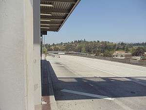
The station is situated along the El Monte Busway transitway lanes of the Interstate 10 (San Bernardino Freeway) and can be accessed from Campus Road close to the Cal State LA campus. At this location, the transitway lanes are on a separate collector/distributor road north of the 10 Freeway mainline. A single railway platform located in the median of the El Monte Busway is used for rail services in both directions; platforms for the Silver Line are located on both sides of the El Monte Busway with the far platform being accessed using stairs and lifts.
Just west of this station the transitway lanes "crossover" (the westbound lanes are south of the eastbound lanes), and they stay that way until the end near Union Station, and just east of this station the transitway moves off the separate right of way and move into the median of Interstate 10.
Busway services
Busway routes stops on the platforms on the freeway levels. The station is split into two platforms. One platform is for the eastbound buses and the other one is for westbound buses.
Other express bus services can be accessed from the Silverline platforms
- Metro Express: 487, 489 (M-F Rush Hour A.M. only for West & P.M. Only for East)
- Foothill Transit: 493, 497, 498, 499, 699 & Silver Streak
Local bus services
Other local bus stops. Access from the top floor via the platform bridge.
- Metro Local: 71, 256, 258, 665
- ACT: Blue
- Monterey Park: 5 from local bus stops outside station.
- LACDPW: El Sol East Los Angeles College/City Terrace route & Edmund D. Edelman Children’s Court Shuttle
Gallery
| Wikimedia Commons has media related to LACMTA Silver Line. |
 Eastbound platform.
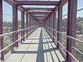 Cal State LA Silver Line bridge to the eastbound platform.
References
- SMA Rail Consulting (April 2016). "California Passenger Rail Network Schematics" (PDF). California Department of Transportation.
- "Cal State L.A. station opens on S.B. rail line". The San Bernardino County Sun. October 27, 1994. p. 3. Retrieved July 6, 2019 – via Newspapers.com.
- "Rail Station Naming" (PDF). Los Angeles County Metropolitan Transportation Authority. July 15, 2010. Retrieved May 24, 2012.
External links
| G Line | |
|---|---|
| J Line | |
| Services |
|  | ||||||||||||
|---|---|---|---|---|---|---|---|---|---|---|---|---|---|---|
| Stations | ||||||||||||||
| Facilities |
| |||||||||||||
| Capital projects | ||||||||||||||
| Fleet | ||||||||||||||
| Other information | ||||||||||||||