Burgess, South Carolina
Burgess is an unincorporated community in Horry County, South Carolina, United States, along South Carolina Highway 707. Burgess is roughly 28 square miles in area and is located between the Waccamaw River/Intracoastal Waterway to the west and U.S. 17 Bypass to the east. [1] Burgess appears on the Brookgreen Gardens U.S. Geological Survey Map.[2]
Burgess, South Carolina | |
|---|---|
Unincorporated Community | |
| Nickname(s): Burgess Community | |
| Country | United States |
| State | South Carolina |
| County | Horry |
| Time zone | Eastern |
| ZIP Code | 29576, 29588 |
| Area code(s) | 843 |
History
According to the 1990 census, the Burgess Community population was approximately 3,000, then grew to 25,000 according to the 2010 census.[1] Burgess during the last 20 years has transitioned from a rural community to a predominantly suburban community. Numerous master planned communities have been developed since 1990 such as TPC, Blackmoor and Laurel Woods. There are large tracts of land that remain undeveloped which retains some of the rural characteristics that preceded it's rapid growth.[1] Burgess also has a community center called Burgess Community Center located on South Carolina Highway 707 near Mt. Zion Church and St. James Middle School and just down the street from St. James High School. During the late 1890s Burgess was an African American farming community.
Major roads/highways
Schools
- St. James High School
- St. James Middle School
- St. James Elementary School
- St. James Intermediate School
- Burgess Elementary School
References
- "Greater Burgess Community Association". Retrieved 4 February 2020.
- "Burgess Populated Place Profile". SC HomeTownLocator. Retrieved 3 February 2014.
External links
Municipalities and communities of Horry County, South Carolina, United States | ||
|---|---|---|
| Cities | 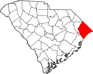 Map of South Carolina highlighting Horry County | |
| Towns | ||
| CDPs | ||
| Unincorporated communities | ||