Burgeo
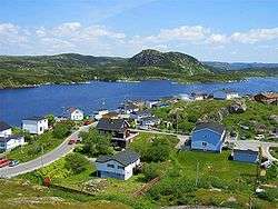
Burgeo (/ˈbɜːrdʒoʊ/ BUR-joh)[2] is a town in the Canadian province of Newfoundland and Labrador. It is located mainly on Grandy Island, on the south coast of the island of Newfoundland.
Burgeo | |
|---|---|
Town | |
 | |
.jpg) Seal | |
 Burgeo Location of Burgeo in Newfoundland | |
| Coordinates: 47°36′00″N 57°38′00″W | |
| Country | |
| Province | |
| Government | |
| • Mayor | John Savoury |
| • MHA | Andrew Parsons (Burgeo and La Poile) |
| • MP | Gudie Hutchings (Long Range Mountains) |
| Population (2016) | |
| • Total | 1,307[1] |
| Time zone | UTC-3:30 (Newfoundland Time) |
| • Summer (DST) | UTC-2:30 (Newfoundland Daylight) |
| Area code(s) | 709 |
| Highways | |
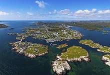 Aerial view of Burgeo Islands | |
The town is approximately 121 kilometres (75 mi) east of Channel-Port aux Basques. Burgeo is home to Sandbanks Provincial Park. The park is named for its sand dunes and long expanses of flat, sandy beaches on the island portion of Newfoundland and Labrador.[3]
Demographics
The population was 900 in 1911, 2,474 in 1976, 1,607 in 2006, 1,464 in 2011 and 1,307 in 2016.[1]
Transport links
There is a ferry dock with connections to Ramea, Grey River and Francois. The town is also the southern terminus for Route 480 (Burgeo Highway), connecting Burgeo with the Trans-Canada Highway (Route 1) and the rest of mainland Newfoundland.[4]
Climate
| Climate data for Burgeo | |||||||||||||
|---|---|---|---|---|---|---|---|---|---|---|---|---|---|
| Month | Jan | Feb | Mar | Apr | May | Jun | Jul | Aug | Sep | Oct | Nov | Dec | Year |
| Record high °C (°F) | 8.7 (47.7) |
8.9 (48.0) |
9.2 (48.6) |
14.8 (58.6) |
21.7 (71.1) |
24.4 (75.9) |
25.9 (78.6) |
26.7 (80.1) |
23.1 (73.6) |
18.6 (65.5) |
14.4 (57.9) |
11.5 (52.7) |
26.7 (80.1) |
| Average high °C (°F) | −1.4 (29.5) |
−2 (28) |
0.5 (32.9) |
4.5 (40.1) |
8.8 (47.8) |
12.6 (54.7) |
16.5 (61.7) |
18.1 (64.6) |
15.2 (59.4) |
10.3 (50.5) |
5.8 (42.4) |
1.3 (34.3) |
7.5 (45.5) |
| Average low °C (°F) | −8.4 (16.9) |
−9.4 (15.1) |
−6.4 (20.5) |
−1.5 (29.3) |
2.4 (36.3) |
6.4 (43.5) |
10.5 (50.9) |
11.4 (52.5) |
7.8 (46.0) |
3.4 (38.1) |
−0.3 (31.5) |
−5.4 (22.3) |
0.9 (33.6) |
| Record low °C (°F) | −19.4 (−2.9) |
−25.6 (−14.1) |
−25.2 (−13.4) |
−12.2 (10.0) |
−7.2 (19.0) |
1.1 (34.0) |
4.4 (39.9) |
3.9 (39.0) |
−0.6 (30.9) |
−4.7 (23.5) |
−12.9 (8.8) |
−18.3 (−0.9) |
−25.6 (−14.1) |
| Average precipitation mm (inches) | 156.7 (6.17) |
130.5 (5.14) |
128.1 (5.04) |
131.6 (5.18) |
125.2 (4.93) |
149.3 (5.88) |
139.9 (5.51) |
138.5 (5.45) |
133.2 (5.24) |
156.9 (6.18) |
175.5 (6.91) |
173.8 (6.84) |
1,739.2 (68.47) |
| Source: 1961-1990 Environment Canada [6] | |||||||||||||
In popular culture
Burgeo appears as a playable area in the 2014 video game Assassin's Creed Rogue.
Notable people
The famed Canadian nature writer and naturalist Farley Mowat lived in Burgeo for five years during his time in Newfoundland.
See also
- List of cities and towns in Newfoundland and Labrador
- Burgeo-La Poile
References
- "Burgeo Census". Statistics Canada. Retrieved 30 June 2018.
- The Canadian Press Stylebook (18th ed.), Toronto: The Canadian Press, The Canadian Press, 2017
- "Sandbanks Provincial Park". Newfoundland and Labrador. Retrieved 15 May 2019.
- "Burgeo". Town of Burgeo. Retrieved 17 March 2018.
- Canada, Environment and Climate Change (9 February 2011). "Canadian Climate Normals 1961-1990 Station Data - Climate - Environment and Climate Change Canada". climate.weather.gc.ca. Retrieved 8 June 2020.
- Environment Canada—Canadian Climate Normals 1961–1990. Retrieved 7 October 2012.