Bunji, Pakistan
Bunji (Urdu:بنجی) (Balti: بنجی) is a small town in Astore District, Gilgit-Baltistan, Pakistan. it is historically important being in the end of Dogra Rule before 1948 and on the brim of Ancient Yagistan. It was economically hub for Barter trade between Yagistan and Dogras. The distance from Bunji to Gilgit is about 50 kilometres (31 mi) on the Karakoram Highway. Bunji, located at the junction of Three Great Mountain Ranges, has its historical importance. The Village has its prominent traces in the socio-political and economical situations of the region in History. River Indus covers the village from North to west while from eastern side it is connected with river Astore. Baltistan region joins its territory from the North-East.
Bunji | |
|---|---|
Town | |
| Bunji | |
   .jpg) | |
 Bunji  Bunji | |
| Coordinates: 35°38′32″N 74°38′01″E | |
| Country | |
| Region | |
| District | Astore District |
| Population (1998) | |
| • Total | 10,000 |
| Time zone | UTC+5:00 (PST) |
| Official Language | Urdu |
| Native language | Balti |
| Languages | 90.1% Balti 9.9% (others) |
Etymology
The town was earlier known as Bawanji.[1] By 20th century, the name had been shortened to Bunji.
History
Bunji is in the Astor principality, which came under the control of Skardu (Baltistan) during the rule of Ali Sher Khan Anchan (r. 1540–1633).[2]
The 19th century geographer Frederic Drew states that Bunji had significant agriculture and horticulture at this time. But it was laid "waste" during the invasions of Sulaiman Shah (ruler of Yasin, c. 1800–1825[3]), after which only a small area was cultivated.[1]
General Zorawar Singh, the governor of Kishtwar under Raja Gulab Singh, conquered Skardu in 1840, and sent his forces to occupy Rondu and Astor. Raja Jabbar Khan of Astor eventually surrendered and he was sent to Zorawar Singh. However, the Sikh governor of Kashmir, Ghulam Mohiuddin, contested Zorawar Singh's claim, and retrieved control of Astor and reinstated Jabbar Khan as his subsidiary.[4]
After the Dogras established the princely state of Jammu and Kashmir under British suzerainty (1846), the Dogras built a fort at Bunji and stationed troops there. Bunji was regarded as a strategic point on the road from Srinagar to Gilgit.[1] In the early years of Dogra rule, Gilgit was repeatedly invaded by Raja Gauhar Rehman of Punial and Bunji troops became involved in the conflicts.[5] The frontier states were subdued only after the British established the Gilgit Agency in 1889.
Until 1935, Bunji was part of the Astore tehsil of the Gilgit wazarat. After that date, the British leased the Gilgit tehsil to the north of Indus as the Gilgit leased area, and Astore became an independent wazarat administered as part of the Kashmir province of the state.[6]
Shortly before the partition of India in 1947, the British transferred the Gilgit Agency to the Maharaja of Jammu and Kashmir. The 6th battalion of Jammu and Kashmir State Forces was sent to Bunji to support the Gilgit Agency (which had its own forces in the form of the Gilgit Scouts). The Muslim troops of the state force battalion, under the leadership of Mirza Hassan Khan, joined the rebellion raised by the Gilgit Scouts on 1 November 1947. Subsequently Bunji was attacked by the Gilgit Scouts and all the non-Muslims of the battalion were taken prisoner. Some of the non-Muslim forces escaped to Skardu where they held out till August 1948.
Demographics
Religion
The place has a Muslim majority and most of the people here are Shia Muslims.
Languages
The most spoken language in Bunji is Balti which is 90.1%. Other languages are also spoken but are 9.9%.
Geography
Climate
The temperature here averages 16.2 °C. In a year, the average rainfall is 190 mm. The warmest month is July and January is the coldest month of the year in Bunji. The driest month is November and with 4 mm of rainfall. In May, the precipitation reaches its highest peak at an average of 34 mm.
| Climate data for Bunji | |||||||||||||
|---|---|---|---|---|---|---|---|---|---|---|---|---|---|
| Month | Jan | Feb | Mar | Apr | May | Jun | Jul | Aug | Sep | Oct | Nov | Dec | Year |
| Average high °F | 46 | 52.2 | 62.1 | 72.5 | 81.9 | 90.9 | 93.9 | 92.1 | 84.9 | 74.3 | 63 | 50.5 | 72.0 |
| Average low °F | 30.7 | 34.7 | 43.2 | 51.4 | 58.1 | 65.3 | 70.3 | 69.6 | 61.2 | 50 | 39.4 | 33.3 | 50.6 |
| Average rainfall inches | 0.4 | 0.6 | 1.1 | 1.3 | 1.3 | 0.3 | 0.6 | 0.6 | 0.4 | 0.5 | 0.2 | 0.3 | 7.6 |
| Average high °C | 8 | 11.2 | 16.7 | 22.5 | 27.7 | 32.7 | 34.4 | 33.4 | 29.4 | 23.5 | 17 | 10.3 | 22.2 |
| Average low °C | −0.7 | 1.5 | 6.2 | 10.8 | 14.5 | 18.5 | 21.3 | 20.9 | 16.2 | 10 | 4.1 | 0.7 | 10.3 |
| Average rainfall mm | 9 | 15 | 28 | 32 | 34 | 8 | 15 | 16 | 9 | 13 | 4 | 7 | 190 |
| Source: [7] | |||||||||||||
Tourism
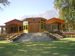
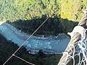
Bunji is a tourist destination in Pakistan. The main attractions are the historic Bunji Mess and the Bunji Bridge.
Bunji Hydropower Project
BHPP is a sub project of Pakistan with a planned capacity of 7100 MW, if constructed. Currently, this project is undergoing a feasibility study and detailed design. The companies conducting the feasibility and detailed design studies are involved in a joint venture, consisted of Mott MacDonald UK, Mott MacDonald Pakistan, Sogreah Consultants (France), Nippon Koei (Japan) and Development & Management consultants (Pakistan). This joint venture is known as Bunji Consultants Joint Venture (BCJV).
The dam site area is located 83 km (52 mi) from Gilgit on Skardu road near Asmani Mor. The proposed powerhouse is located in the Bunji village.
See also
| Wikimedia Commons has media related to Bunji. |
- Karakoram Highway
- Gilgit Baltistan
- Astore District
- Astore
- Gorikot
- Gudai
- Famous Personalities
References
- Drew, Frederic (1875), The Jummoo and Kashmir Territories: A Geographical Account, London: Edward Stanford
- Pirumshoev & Dani, The Pamirs, Badakhshan and the Trans-Pamir States (2003), p. 246.
- Pirumshoev & Dani, The Pamirs, Badakhshan and the Trans-Pamir States (2003), p. 245.
- Charak, General Zorawar Singh (1983), pp. 57–58.
- Brahma Singh, History of Jammu and Kashmir Rifles (2010).
- Census of India, 1941, Volume XXII (1943), p. 3.
- "Bunji Climate". Climate-Data.
Bibliography
- Census of India, 1941, Volume XXII – Jammu and Kashmir, Parts I & II, The Ranbir Government Press, 1943
- Charak, Sukhdev Singh (1983), General Zorawar Singh, Publications Division, Government of India – via archive.org
- Pirumshoev, H. S.; Dani, Ahmad Hasan (2003), "The Pamirs, Badakhshan and the Trans-Pamir States", in Chahryar Adle; Irfan Habib (eds.), History of Civilizations of Central Asia, Vol. V — Development in contrast: From the sixteenth to the mid-nineteenth century (PDF), UNESCO, pp. 225–246, ISBN 978-92-3-103876-1
- Singh, K. Brahma (2010) [first published Lancer International 1990], History of Jammu and Kashmir Rifles, 1820-1956: The State Force Background (PDF), brahmasingh.co.nf, ISBN 978-81-7062-091-4