Brookside, Delaware
Brookside is a census-designated place (CDP) in New Castle County, Delaware, United States. The population was 14,353 at the 2010 census.
Brookside, Delaware | |
|---|---|
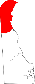
 Location in New Castle County and the state of Delaware. | |
 Brookside Location within the state of Delaware  Brookside Brookside (the United States) | |
| Coordinates: 39°40′01″N 75°43′37″W | |
| Country | United States |
| State | Delaware |
| County | New Castle |
| Area | |
| • Total | 3.9 sq mi (10.1 km2) |
| • Land | 3.9 sq mi (10.1 km2) |
| • Water | 0.0 sq mi (0.0 km2) |
| Elevation | 75 ft (23 m) |
| Population (2010) | |
| • Total | 14,353 |
| • Density | 3,680.3/sq mi (1,421.1/km2) |
| Time zone | UTC-5 (Eastern (EST)) |
| • Summer (DST) | UTC-4 (EDT) |
| Area code(s) | 302 |
| FIPS code | 10-09850 |
| GNIS feature ID | 213721[1] |
Geography
Brookside is located at 39°40′01″N 75°43′37″W (39.6670561, -75.7268779).[2]
According to the United States Census Bureau, the CDP has a total area of 3.9 square miles (10 km2), all of it land.
Demographics
| Historical population | |||
|---|---|---|---|
| Census | Pop. | %± | |
| 1970 | 7,856 | — | |
| 1980 | 15,255 | 94.2% | |
| 1990 | 15,307 | 0.3% | |
| 2000 | 14,086 | −8.0% | |
| 2010 | 14,353 | 1.9% | |
| source:[3][4] | |||
At the 2000 census,[5] there were 14,806 people, 5,465 households and 3,858 families living in the CDP. The population density was 3,787.7 per square mile (1,462.1/km²). There were 5,645 housing units at an average density of 1,444.1 per square mile (557.4/km²). The racial makeup of the CDP was 77.35% White, 15.03% African American, 0.32% Native American, 2.61% Asian, 0.07% Pacific Islander, 2.22% from other races, and 2.40% from two or more races. Hispanic or Latino of any race were 5.59% of the population.
There were 5,465 households of which 35.9% had children under the age of 18 living with them, 49.9% were married couples living together, 15.4% had a female householder with no husband present, and 29.4% were non-families. 22.1% of all households were made up of individuals and 6.8% had someone living alone who was 65 years of age or older. The average household size was 2.68 and the average family size was 3.15.
Age distribution was 26.8% under the age of 18, 9.6% from 18 to 24, 33.2% from 25 to 44, 20.5% from 45 to 64, and 9.9% who were 65 years of age or older. The median age was 34 years. For every 100 females, there were 96.3 males. For every 100 females age 18 and over, there were 91.9 males.
The median household income was $50,107, and the median family income was $55,077. Males had a median income of $37,040 versus $29,494 for females. The per capita income for the CDP was $19,527. About 5.6% of families and 7.4% of the population were below the poverty line, including 9.4% of those under age 18 and 9.0% of those age 65 or over.
Education
Delaware School for the Deaf is in Brookside.[6][7]
References
- "Brookside". Geographic Names Information System. United States Geological Survey.
- "US Gazetteer files: 2010, 2000, and 1990". United States Census Bureau. 2011-02-12. Retrieved 2011-04-23.
- "CENSUS OF POPULATION AND HOUSING (1790-2000)". U.S. Census Bureau. Retrieved 2010-07-17.
- Returned as Brookside Park during the 1970 census
- "U.S. Census website". United States Census Bureau. Retrieved 2008-01-31.
- "2010 CENSUS - CENSUS BLOCK MAP: Brookside CDP, DE" (PDF). U.S. Census Bureau. Retrieved 2020-06-26. - Compare the map to the whole address of Delaware School for the Deaf.
- "Home". Delaware School for the Deaf. Retrieved 2020-06-26.
630 E. Chestnut Hill Road Newark, DE 19713
- Compare the whole address to the CDP map.