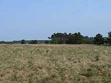
Breckland
Breckland in Norfolk and Suffolk is a 39,433 hectare Special Protection Area (SPA) under the European Union Directive on the Conservation of Wild Birds.[1][2] The SPA partly overlaps the 7,544 hectare Breckland Special Area of Conservation.[3][4] As a landscape region it is an unusual natural habitat of England. It comprises the gorse-covered sandy heath that lies mostly in the south of the county of Norfolk but also in the north of Suffolk. An area of considerable interest for its unusual flora and fauna, it lies to the east of another unusual habitat, the Fens, and to the south west of the Broads. The typical tree of this area is the Scots pine. Breckland is one of the driest areas in England.
The area of Breckland has been substantially reduced in the twentieth century by the impact of modern farming and the creation in 1914 of Thetford Forest. However substantial areas have been preserved, not least by the presence of the British Army on the Stanford Battle Area.
Breckland is one of the few areas in England where the rare and shy (but non-indigenous) golden pheasant may be seen in the wild.
During the Prehistoric period Breckland was mined for flint, evidence for which can be found at Grimes Graves just outside Thetford in Norfolk. The word 'Breck' is medieval and was defined as being an area of heathland broken up for cultivation before being allowed to retreat back into wilderness. Up until 200 years ago, much of it consisted of open heathland. The Brecks today are a tourist attraction as well as an area of scientific and geographical interest.
The Breckland landscape region has given its name to Breckland District, a local government district that contains most of Norfolk's portion of the Breckland. Parts of Forest Heath and St Edmundsbury districts cover the Suffolk portion.
The Great Eastern Pingo Trail is 8 miles of tracks and paths exploring the eastern edge of the Breckland area. The trail takes in the commons at the villages of Thompson and Stow Bedon, and heathland at Breckles and Great Hockham. Thompson Water, an artificial lake, and the woodland at Thompson Carr also form part of the walk. The name of the trail comes from the former Great Eastern Railway and the large number of collapsed pingos found in the area. The trail may be accessed as a detour from the Peddars Way long distance footpath.[5] It is a Local Nature Reserve.[6][7]
A Pool Frog (Pelophylax lessonae) reintroduction project was started in 2005 by English Nature.[8]
References
- "Designated Sites View: Breckland". Special Protection Area. Natural England. Retrieved 10 May 2017.
- "Special Protection Areas under the EC Birds Directive. Breckland" (PDF). Joint Nature Conservation Committee. Retrieved 4 May 2017.
- "Breckland". Special Areas of Conservation. Joint Nature Conservation Committee. Retrieved 4 May 2017.
- "Designated Sites View: Breckland". Special Area of Conservation. Natural England. Retrieved 10 May 2017.
- Kelly, Tony (28 September 1997). "Take a walk on the Wildlife side..." Independent on Sunday. Retrieved 27 June 2009.
- "Great Eastern Pingo Trail". Local Nature Reserves. Natural England. Archived from the original on 4 August 2013. Retrieved 4 August 2013.
- "Map of Great Eastern Pingo Trail". Local Nature Reserves. Natural England. Retrieved 4 August 2013.
- "Frog with Norfolk accent returns". 11 August 2005. Retrieved 8 April 2020.
External links
- The Brecks
- www.countrysideaccess.norfolk.gov.uk
- The Breckland Society
- Dyckhoff, Tom (8 February 2003). "Let's move to... The Breckland, Norfolk". The Guardian. Retrieved 27 June 2009.
- Schoon, Nicholas (13 March 1993). "Unique wilderness that faces a fight to survive: Farmers in East Anglia are being paid to help recreate a sandy heathland". The Independent. Retrieved 27 June 2009.
- Bailey, Mark (1989). A marginal economy?: East Anglian Breckland in the later Middle Ages (PDF) (Illustrated ed.). Cambridge University Press. p. 350. ISBN 0-521-36501-5.
| Authority control |
|
|---|