Brayton railway station
Brayton was a railway station which served as the interchange for the Solway Junction Railway (SJR) with the Maryport and Carlisle Railway (M&CR); it also served nearby Brayton Hall and district in Cumbria. The station was opened by the M&CR and became a junction station in 1870 on the 25 mile long SJR line.[1]
| Brayton railway station | |
|---|---|
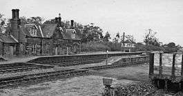 Brayton station in 1961 | |
| Location | |
| Place | Brayton Hall |
| Area | Allerdale |
| Coordinates | 54.7808°N 3.2980°W |
| Grid reference | NY166436 |
| Operations | |
| Pre-grouping | Maryport & Carlisle Railway |
| Post-grouping | London Midland and Scottish Railway |
| Platforms | 3 |
| History | |
| 1844 | Opened as private station |
| 1 March 1848 | Opened to public passengers |
| 5 June 1950 | Station closed to passengers |
| 27 September 1965 | Closed to goods |
| Disused railway stations in the United Kingdom | |
| Closed railway stations in Britain A B C D–F G H–J K–L M–O P–R S T–V W–Z | |
| Maryport and Carlisle Railway | ||||||||||||||||||||||||||||||||||||||||||||||||||||||||||||||||||||||||||||||||||||||||||||||||||||||||||||||||||||||||||||||||||||||||||||||||||||||||||||||||||||||||||||||||||||||||||||||||||||||||||||||
|---|---|---|---|---|---|---|---|---|---|---|---|---|---|---|---|---|---|---|---|---|---|---|---|---|---|---|---|---|---|---|---|---|---|---|---|---|---|---|---|---|---|---|---|---|---|---|---|---|---|---|---|---|---|---|---|---|---|---|---|---|---|---|---|---|---|---|---|---|---|---|---|---|---|---|---|---|---|---|---|---|---|---|---|---|---|---|---|---|---|---|---|---|---|---|---|---|---|---|---|---|---|---|---|---|---|---|---|---|---|---|---|---|---|---|---|---|---|---|---|---|---|---|---|---|---|---|---|---|---|---|---|---|---|---|---|---|---|---|---|---|---|---|---|---|---|---|---|---|---|---|---|---|---|---|---|---|---|---|---|---|---|---|---|---|---|---|---|---|---|---|---|---|---|---|---|---|---|---|---|---|---|---|---|---|---|---|---|---|---|---|---|---|---|---|---|---|---|---|---|---|---|---|---|---|---|---|
| ||||||||||||||||||||||||||||||||||||||||||||||||||||||||||||||||||||||||||||||||||||||||||||||||||||||||||||||||||||||||||||||||||||||||||||||||||||||||||||||||||||||||||||||||||||||||||||||||||||||||||||||
History
Brayton station was opened by the Maryport & Carlisle Railway in 1844. Originally a private station it opened to the public on 1 March 1848.[2] At grouping in 1923 the M&CR became a part of the London, Midland and Scottish Railway. The main Carlisle-Maryport line (completed in 1845) remains open and forms part of the Cumbrian Coast Line between Carlisle and Barrow in Furness.
A shed opened to the east of Brayton at the 21 mile post on 13 September 1869 with two roads, sidings and a 42 ft turntable in the junction between the Solway Junction Railway and the Maryport and Carlisle Railway, used by both companies.[3] On the north side of the station were extensive Solway Junction sidings and on the other side was a through loop that allowed shunting operations to be carried out.[4]
The passenger service via the Solway Junction Railway was never very successful and declined to being just one carriage at the front of an occasional goods train and in September 1917 this was suspended,[5] but was reinstated in 1920.[6] One mid morning train used to run mixed between Kirtlebridge and Bowness, continuing as freight only to Brayton.[7] Passenger services were finally withdrawn in 1921 and the line south of Annan over the Solway Viaduct was closed completely. The line remained open to through traffic until 14 February 1933 and the track was lifted on the S&JR in 1937.[8] The station closed to passengers on the Carlisle route on 5 June 1950[2] and to all traffic in 1965.
The station had three platforms, two through and one bay, with substantial station buildings and a signal box.[9]
The Brayton Dominion Colliery (Pit No. 4) was located nearby with an extensive railway network.[9]
References
- Notes
- Edgar & Sinton 1990, p. 12.
- Quick 2009, p. 98.
- Edgar & Sinton 1990, p. 66.
- Edgar & Sinton 1990, p. 68.
- Edgar & Sinton 1990, p. 58.
- "The Solway Viaduct - Southern End". Retrieved 2 August 2012.
- Edgar & Sinton 1990, p. 21.
- Edgar & Sinton 1990, p. 57.
- Edgar & Sinton 1990, p. 52.
- Sources
- Quick, Michael (2009) [2001]. Railway passenger stations in Great Britain: a chronology (4th ed.). Oxford: Railway and Canal Historical Society. ISBN 978-0-901461-57-5. OCLC 612226077.
- Edgar, Stuart & Sinton, John M. (1990). The Solway Junction Railway. Oxford: Oakwood Press. ISBN 978-0853613954.CS1 maint: ref=harv (link)
- Further reading
- Jowett, Alan (March 1989). Jowett's Railway Atlas of Great Britain and Ireland: From Pre-Grouping to the Present Day (1st ed.). Sparkford: Patrick Stephens Ltd. ISBN 978-1-85260-086-0. OCLC 22311137.
- Jowett, Alan (2000). Jowett's Nationalised Railway Atlas (1st ed.). Penryn, Cornwall: Atlantic Transport Publishers. ISBN 978-0-906899-99-1. OCLC 228266687.
- RAILSCOT on Solway Junction Railway
- Railways of the Solway Plain
External links
| Preceding station | Historical railways | Following station | ||
|---|---|---|---|---|
| Bromfield Line and station closed |
Caledonian Railway Solway Junction Railway |
Connection with M&CR | ||
| Leegate Station closed, line open |
Maryport & Carlisle Railway Maryport and Carlisle Railway |
Aspatria Line and station open | ||