Braunlage
Braunlage is a town and health resort in the Goslar district in Lower Saxony in Germany. Situated within the Harz mountain range, south of the Brocken massif, Braunlage's main business is tourism, particularly skiing. Nearby ski resorts include the Sonnenberg and the slopes on the Wurmberg.
Braunlage | |
|---|---|
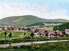
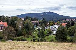 Braunlage with the Wurmberg mountain behind | |
 Coat of arms | |
Location of Braunlage within Goslar district 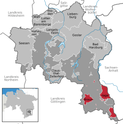 | |
 Braunlage  Braunlage | |
| Coordinates: 51°43′37″N 10°36′43″E | |
| Country | Germany |
| State | Lower Saxony |
| District | Goslar |
| Subdivisions | 3 districts |
| Government | |
| • Mayor | Stefan Grote (SPD) |
| Area | |
| • Total | 31.55 km2 (12.18 sq mi) |
| Elevation | 560 m (1,840 ft) |
| Population (2018-12-31)[1] | |
| • Total | 5,854 |
| • Density | 190/km2 (480/sq mi) |
| Time zone | CET/CEST (UTC+1/+2) |
| Postal codes | 38700 |
| Dialling codes | 05520 |
| Vehicle registration | GS, BRL, CLZ |
| Website | www |
Geography
Braunlage is located on the Warme Bode, a headstream of the Bode river, close to the border with Elend in the state of Saxony-Anhalt. The municipal area stretches along the southeastern rim of the Harz National Park from an elevation of 550 m (1,800 ft) up to 971 m (3,186 ft) at the Wurmberg summit. Other peaks in the vicinity include the Achtermannshöhe and the Hahnenklee Crags.
Districts
The town[2] consists of three districts:
- Braunlage proper
- Hohegeiß*, incorporated on 1 July 1972
- Sankt Andreasberg**, incorporated on 1 November 2011
* with the village of Königskrug
** with the villages of Sonnenberg, Oderhaus, Oderbrück, Oderberg, Odertaler Sägemühle and Silberhütte
Transportation
Braunlage is situated at the Bundesstraße B4 running from Braunschweig to Nordhausen and B27 from Blankenburg to Göttingen.
Local buses provide service between Braunlage and the nearby communities of Bad Harzburg, Sankt Andreasberg, Schierke, Wernigerode, Hohegeiß, Bad Sachsa, Nordhausen, Bad Lauterberg, Herzberg, and Clausthal-Zellerfeld.[3]
Braunlage used to be served by the South Harz Railway Company, providing a link to the Harz Narrow Gauge Railways via Sorge, but service was cut in 1958.
Climate
History
First mentioned as Brunla in 1227, the town started out as a pit settlement in the Harz forests. It appeared as Brunenlo in a 1253 register of the Saxon counts of Regenstein and was revived, when their successors, the Counts of Blankenburg, established an ironworks here in 1561. With the extinction of the Blankenburg dynasty in 1599, Braunlage fell to the Dukes of Brunswick-Wolfenbüttel.
In the 17th century it was a small Brunswick market town located in the western part of the former Blankenburg lands. Tourism developed from the late 19th century onwards, other branches of business were forestry and a large granite quarry at the Wurmberg. Around 1910, one of the first interurban bus lines ran from Bad Harzburg up to Braunlage, served by Büssing vehicles. The Wurmberg Ski Jumps were erected in 1922 (demolished in 2014). In 1934 Braunlage received town privileges and municipal status as a health resort.
After World War II, Braunlage was located close to the fortified inner German border which ran through the Harz mountains. In 1963 it became the location of the Wurmberg Gondola Lift, today with a length of 2.8 kilometres (1.7 mi) and a height difference of 400 m (1,300 ft) to the summit station the longest in Northern Germany. On 7 May 1964 Gerhard Zucker demonstrated a flight of mail rockets on the Hasselkopf hill. One of these rockets exploded, killing two spectators.
Since German reunification in 1990, Braunlage again is located in the centre of the Harz touristic region, however, it had to cope with growing competition by the neighbouring resorts in Saxony-Anhalt.
Demographics
|
|
|
|
Politics
Town council
Seats in the town council (Stadtrat) as of 2016 local elections:
- Christian Democratic Union (CDU): 7
- Bürgerliste (independent): 5
- Social Democratic Party of Germany (SPD): 4
Culture and sights
A museum of local history covers Braunlage's tradition as a health resort and official venue of the International Ski Federation (FIS). The townscape includes extended spa gardens
Sports
The local hockey team Harzer Wölfe is an important part of the northern German Ice Hockey Culture.
There were several ski jumps on the Wurmberg, which hosted international competitions such as the FIS Ski Jumping Continental Cup until 2011.
Sights
The Silberteich and the Hahnenkleeklippen on the way to Sankt Andreasberg are popular tourist destinations.
The Dicke Tannen is a protected landscape of giant spruce trees near Hohegeiß.
References
- Landesamt für Statistik Niedersachsen, LSN-Online Regionaldatenbank, Tabelle 12411: Fortschreibung des Bevölkerungsstandes, Stand 31. Dezember 2018.
- "Einwohner der Gemeinden und Ortsteile" (PDF). Landkreis - Goslar.
- "Öffentlicher Nahverkehr". Retrieved 4 October 2016.
External links
| Wikimedia Commons has media related to Braunlage. |

- Braunlage Tourism
- Braunlage at Curlie
Towns and municipalities in Goslar (district) | ||
|---|---|---|
Coat of arms | ||
| Authority control |
|
|---|