Bomaderry, New South Wales
Bomaderry is a town in the Shoalhaven council district area of New South Wales, Australia. At the 2016 census, it had a population of 6,661 people.[1] It is on the north shore of the Shoalhaven River, across the river from Nowra, the major town of the City of Shoalhaven, of which Bomaderry is locally regarded as being a suburb of the city.
| Bomaderry Shoalhaven, New South Wales | |||||||||||||||
|---|---|---|---|---|---|---|---|---|---|---|---|---|---|---|---|
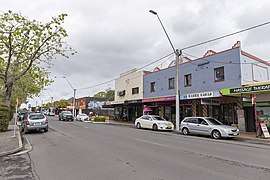 Meroo Street in Bomaderry | |||||||||||||||
Bomaderry | |||||||||||||||
| Coordinates | 34.848°S 150.605°E | ||||||||||||||
| Population | 6,661 (2016 census)[1] | ||||||||||||||
| Established | 1892 | ||||||||||||||
| LGA(s) | City of Shoalhaven | ||||||||||||||
| State electorate(s) | Kiama | ||||||||||||||
| Federal Division(s) | Gilmore | ||||||||||||||
| |||||||||||||||
History
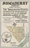
Bomaderry township was opened in 1892.[2] It was previously part of the Shoalhaven Estate owned by David Berry whose brother Alexander Berry had built a road to the area in 1858. When David died in 1889 the estate was sold in portions. The subdivision plans for Bomaderry are shown. In 1893 the railway was extended to Bomaderry and the town began to grow from this time.
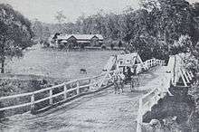
One of the first houses in Bomaderry was Lynburn which still exists today. It was built in 1895 by the architect Howard Joseland[3] for Jane Morton, the widow of Henry Gordon Morton, the manager of the Shoalhaven Estate. A photo shortly after its construction is shown. The road over the bridge in the photo is now the Princes Highway where it crosses Bomaderry Creek.
After the town opened in 1892 several factories moved into the area. Messrs Denham Bros. built a bacon and ham factory in about 1900.[4] A milk condensery opened in 1901 which was originally located near the railway station[5] but later moved to the bank of the Shoalhaven River close to Bolong Road.[6] In 1912 the Nowra Co-op Dairy Company established a milk Depot at Bomaderry[7] and this was a major boost to the local economy for many years.
Heritage listings
Bomaderry has a number of heritage-listed sites, including:
- 59 Beinda Street: Bomaderry Aboriginal Children's Home[8]
- Illawarra railway: Bomaderry railway station[9]
Transport
Its railway station is the terminus of the South Coast railway line, which is part of the NSW TrainLink network.
Education
Bomaderry High School is one of the major high schools in the Shoalhaven. Nowra Anglican College is a K-12 school located in Bomaderry. Bomaderry Public School is the main primary school in the area with over 250 students.
Population
According to the 2016 census of Population, there were 6,661 people in Bomaderry.
- Aboriginal and Torres Strait Islander people made up 7.4% of the population.
- 79.7% of people were born in Australia. The next most common country of birth was England at 4.1%.
- 88.5% of people spoke only English at home.
- The most common responses for religion were No Religion 28.4%, Anglican 24.4% and Catholic 18.7%.[1]
Footnotes
- Australian Bureau of Statistics (27 June 2017). "Bomaderry (State Suburb)". 2016 Census QuickStats. Retrieved 9 July 2017.

- Northern Star (Lismore), 6 April 1892, p. 2. Online reference
- NSW Heritage register, Lynburn. Online reference
- The Sydney Mail, 14 December 1901, 1492. Online reference
- Shoalhaven Telegraph, 4 December 1901, p. 1. condenser bomaderry&searchLimits=l-decade=190 Online reference
- The Shoalhaven Telegraph, 20 October 1926, p. 8. cooperative bomaderry&searchLimits= Online reference
- The Kiama Independent and Shoalhaven Advertiser, 17 April 1912, p. 2. cooperative bomaderry&searchLimits= Online reference
- "Bomaderry Aboriginal Children's Home". New South Wales State Heritage Register. Office of Environment and Heritage. H01874. Retrieved 18 May 2018.
- "Bomaderry Railway Station and yard group". New South Wales State Heritage Register. Office of Environment and Heritage. H01090. Retrieved 18 May 2018.