Bluebell, Utah
Bluebell is a census-designated place in eastern Duchesne County, Utah, United States, on the Uintah and Ouray Indian Reservation. The population as of the 2010 census was 293.[2] It lies along local roads east of State Route 87, northeast of the city of Duchesne, the county seat of Duchesne County.[3] Its elevation is 6,201 feet (1,890 m) above sea level.[1] Although Bluebell is unincorporated, it has a post office, with the ZIP code of 84007.[4]
Bluebell, Utah | |
|---|---|
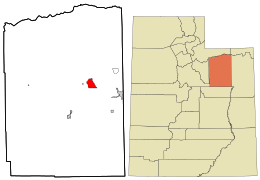 Location in Duchesne County and the state of Utah | |
| Coordinates: 40°21′34″N 110°13′3″W | |
| Country | United States |
| State | Utah |
| County | Duchesne |
| Area | |
| • Total | 9.76 sq mi (25.28 km2) |
| • Land | 9.74 sq mi (25.23 km2) |
| • Water | 0.02 sq mi (0.05 km2) |
| Elevation | 6,201 ft (1,890 m) |
| Population (2010) | |
| • Total | 293 |
| • Density | 30/sq mi (11.6/km2) |
| Time zone | UTC-7 (Mountain (MST)) |
| • Summer (DST) | UTC-6 (MDT) |
| ZIP codes | 84007 |
| FIPS code | 49-06590 |
| GNIS feature ID | 1425831[1] |
Bluebell was first settled by Elmer Gates in 1907.
Bluebell's most notable old families include the Remingtons, the Winklers, the Monsens, and the Goodriches. Its most notable attractions include Bluebell Store, the Monsen Family Corn Maze, and Bluebell Cemetery.
Climate
According to the Köppen Climate Classification system, Bluebell has a semi-arid climate, abbreviated "BSk" on climate maps.[5]
References
- "Bluebell, Utah". Geographic Names Information System. United States Geological Survey. Retrieved 2008-04-12.
- Utah Trend Report 2: State and Complete Places (Sub-state 2010 Census Data). Archived 2012-07-19 at Archive.today Missouri Census Data Center. Accessed 2011-02-25.
- Rand McNally. The Road Atlas '08. Chicago: Rand McNally, 2008, p. 103.
- Zip Code Lookup Archived May 17, 2011, at the Wayback Machine
- Climate Summary for Bluebell, Utah
External links
![]()
Municipalities and communities of Duchesne County, Utah, United States | ||
|---|---|---|
| Cities | 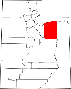 Map of Utah highlighting Duchesne County | |
| Towns | ||
| CDPs | ||
| Unincorporated communities | ||
| Indian reservation | ||
| Ghost town | ||
| Footnotes | ‡This populated place also has portions in an adjacent county or counties | |