Bientina
Bientina (Italian: [ˈbjɛntina]) is a comune (municipality) in the Province of Pisa in the Italian region Tuscany.
Bientina | |
|---|---|
| Comune di Bientina | |
 | |
 Coat of arms | |
Location of Bientina 
| |
 Bientina Location of Bientina in Italy 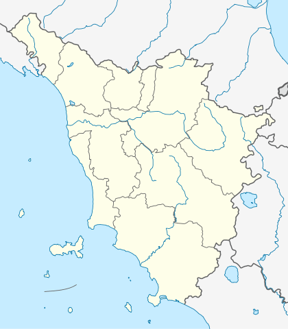 Bientina Bientina (Tuscany) | |
| Coordinates: 43°43′N 10°37′E | |
| Country | Italy |
| Region | Tuscany |
| Province | Pisa (PI) |
| Frazioni | Caccialupi, Puntone, Quattro Strade, Santa Colomba |
| Government | |
| • Mayor | Dario Carmassi |
| Area | |
| • Total | 29.48 km2 (11.38 sq mi) |
| Elevation | 10 m (30 ft) |
| Population (31 March 2017)[2] | |
| • Total | 8,285 |
| • Density | 280/km2 (730/sq mi) |
| Demonym(s) | Bientinesi |
| Time zone | UTC+1 (CET) |
| • Summer (DST) | UTC+2 (CEST) |
| Postal code | 56031 |
| Dialing code | 0587 |
| Patron saint | St. Valentine |
| Saint day | June 5 |
| Website | Official website |
History
The toponym Bientina is attested the first time in 793 as Blentina and probably comes from the Etruscan name Plitine.
Geography
.svg.png)
Territory
Bientina is located between Lucca's plain (Piana di Lucca) and the Valdarno.
It is about 50 kilometres (31 mi) to the west of Florence and about 15 kilometres (9 mi) east of Pisa and it borders the following municipalities: Altopascio, Buti, Calcinaia, Capannori, Castelfranco di Sotto, Santa Maria a Monte, Vicopisano.
To the north of the town there was once the largest lake in Tuscany, the Lago di Bientina, until it was drained in 1859 and converted to farmland.
The municipality is formed by the municipal seat of Bientina and the villages (frazioni) of Caccialupi, Puntone, Quattro Strade and Santa Colomba.
Climate
Bientina experiences a Mediterranean Climate like other cities in Central Italy.
Being more distant from the sea, winters are usually less mild than Pisa and summers are warmer.
The climatic classification is "Zone D, 1856 GR/G"[3]
Main sights
Religious architecture
- Church of San Domenico (1621)
- Church of Santa Maria Assunta (medieval - expanded and renovated in the mid-1600)
- Church of Madonna del Bosco in Santa Colomba
- Oratory of San Girolamo (1640), home to the museum of ancient history of Bientina
- Oratory of San Pietro and Rocco (17th century)
- Oratory of San Giusto, the first church of Bientina (12th century)
Civil architecture
- Palazzo Pancani
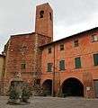
- La Mora tower (13th century)
- Torre Civica (Torre del Frantoio) (13th century) - center of cultural activity.
- Torre del Giglio (13th century)
- Loggetta del Palazzo Comunale (17th century)
 Church of San Domenico
_01.JPG) La Mora tower
La Mora tower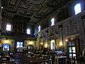 Church of Santa Maria Assunta
 Fountain in Piazza Vittorio Emanuele
Transport
Roads
Bientina is crossed by the Strada provinciale 439 Sarzanese Valdera and some secondary roads. Public transportation is performed by the company CTT Nord.
International relations
Bientina is twinned with ![]()
References
- "Superficie di Comuni Province e Regioni italiane al 9 ottobre 2011". Istat. Retrieved 16 March 2019.
- All demographics and other statistics: Italian statistical institute Istat.
- "Tabella dei gradi/giorno dei Comuni italiani raggruppati per Regione e Provincia" (PDF).
- "Gemellaggio". www.comune.bientina.pi.it. Archived from the original on 2015-11-27. Retrieved 2015-11-21.
External links
| Wikimedia Commons has media related to Bientina. |

| Authority control |
|
|---|