Berlin, Maryland
Berlin is a town in Worcester County, Maryland, United States which includes its own historical Berlin Commercial District. The population was 4,485 at the 2010 census, and has since grown in population. It is part of the Salisbury, Maryland-Delaware Metropolitan Statistical Area.
Berlin, Maryland | |
|---|---|
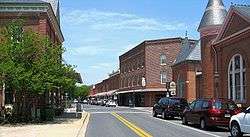 Downtown Berlin, Maryland | |
 Location in Worcester County and the state of Maryland | |
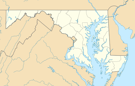 Berlin Location within the state of Maryland  Berlin Berlin (the United States) | |
| Coordinates: 38°20′N 75°13′W | |
| Country | |
| State | |
| County | |
| Incorporated | 1868 |
| Government | |
| • Mayor | William "Gee" Williams III |
| • Town Council | Member List
|
| Area | |
| • Total | 3.42 sq mi (8.86 km2) |
| • Land | 3.38 sq mi (8.75 km2) |
| • Water | 0.04 sq mi (0.10 km2) |
| Elevation | 36 ft (11 m) |
| Population | |
| • Total | 4,485 |
| • Estimate (2018)[3] | 4,818 |
| • Density | 1,372.19/sq mi (529.84/km2) |
| Time zone | UTC-5 (Eastern (EST)) |
| • Summer (DST) | UTC-4 (EDT) |
| ZIP code | 21811 |
| Area code(s) | 410, 443 |
| FIPS code | 24-06800 |
| GNIS feature ID | 0583167 |
| Website | http://berlinmd.gov |
History
The town of Berlin had its start around the 1790s, part of the Burley Plantation, a 300-acre (1.2 km2) land grant dating back to 1677. The name Berlin is believed to be derived from a contraction of "Burleigh Inn", a tavern located at the crossroads of the Philadelphia Post Road (now South Main Street) and Sinepuxent Road (Tripoli Street). This may be why the traditional pronunciation of the town's name is /ˈbɜːrlən/ BUR-lən, as opposed to the more modern pronunciations /ˈbɛərlɪn/ BAIR-lin and /bɛərˈlɪn/ bair-LIN.
Berlin incorporated as a town in 1868. In the early 20th century, Berlin was known as a rest stop for travelers on their way to the coastal resort of Ocean City, as well as a stop for tourists who enjoyed hunting and fishing on the lower Eastern Shore of Maryland. Just to the north of the town center of Berlin is Ocean Pines, Maryland, a waterfront census-designated place (CDP) that shares the same ZIP code as Berlin.
Since the late 1980s, the town has undergone considerable revitalization of its historic downtown commercial district and adjacent residential areas. Berlin's historic residential areas feature nearly two centuries of architectural heritage from three distinct periods: Federal, Victorian, and 20th Century. Forty-seven of these structures have been noted in the National Register of Historic Places and the Berlin Commercial District. Berlin has also been designated as a "Main Street Community" by the State of Maryland in recognition of its revitalization progress.
In addition to the Berlin Commercial District, the Buckingham Archeological Site, Burley Manor, Caleb's Discovery, Fassitt House, Genesar, Henry's Grove, Merry Sherwood and Williams Grove are listed on the National Register of Historic Places.[4]
Geography
Berlin is located at 38°20'N 75°13'W (38.3311,-75.2140).
According to the United States Census Bureau, the town has a total area of 3.15 square miles (8.16 km2), all land.[5]
Demographics
| Historical population | |||
|---|---|---|---|
| Census | Pop. | %± | |
| 1860 | 834 | — | |
| 1870 | 697 | −16.4% | |
| 1880 | 1,055 | 51.4% | |
| 1890 | 974 | −7.7% | |
| 1900 | 1,246 | 27.9% | |
| 1910 | 1,317 | 5.7% | |
| 1920 | 1,366 | 3.7% | |
| 1930 | 1,480 | 8.3% | |
| 1940 | 1,435 | −3.0% | |
| 1950 | 2,001 | 39.4% | |
| 1960 | 2,046 | 2.2% | |
| 1970 | 1,942 | −5.1% | |
| 1980 | 2,162 | 11.3% | |
| 1990 | 2,616 | 21.0% | |
| 2000 | 3,491 | 33.4% | |
| 2010 | 4,485 | 28.5% | |
| Est. 2018 | 4,818 | [3] | 7.4% |
| U.S. Decennial Census[6] | |||

2010 census
As of the census[2] of 2010, there were 4,485 people, 1,688 households, and 1,155 families residing in the town. The population density was 1,423.8 inhabitants per square mile (549.7/km2). There were 1,953 housing units at an average density of 620.0 per square mile (239.4/km2). The racial makeup of the town was 68.8% White, 23.3% African American, 0.6% Native American, 1.4% Asian, 2.7% from other races, and 3.3% from two or more races. Hispanic or Latino of any race were 5.5% of the population.
There were 1,688 households, of which 36.9% had children under the age of 18 living with them, 45.3% were married couples living together, 19.5% had a female householder with no husband present, 3.6% had a male householder with no wife present, and 31.6% were non-families. 25.9% of all households were made up of individuals, and 12.8% had someone living alone who was 65 years of age or older. The average household size was 2.55 and the average family size was 3.07.
The median age in the town was 38.4 years. 25.8% of residents were under the age of 18; 7.3% were between the ages of 18 and 24; 25.1% were from 25 to 44; 24% were from 45 to 64; and 17.7% were 65 years of age or older. The gender makeup of the town was 45.5% male and 54.5% female.
2000 census
As of the census[7] of 2000, there were 3,491 people, 1,347 households, and 880 families residing in the town. The population density was 1,587.2 people per square mile (612.7/km2). There were 1,427 housing units at an average density of 648.8 per square mile (250.4/km2). The racial makeup of the town was 63.74% White, 32.03% African American, 0.20% Native American, 1.52% Asian, 0.03% Pacific Islander, 0.97% from other races, and 1.52% from two or more races. Hispanic or Latino of any race were 3.38% of the population.
There were 1,347 households, out of which 34.1% had children under the age of 18 living with them, 40.2% were married couples living together, 21.0% had a female householder with no husband present, and 34.6% were non-families. 29.7% of all households were made up of individuals, and 18.3% had someone living alone who was 65 years of age or older. The average household size was 2.46 and the average family size was 3.01.
In the town, the population was spread out, with 26.1% under the age of 18, 7.4% from 18 to 24, 26.2% from 25 to 44, 19.9% from 45 to 64, and 20.4% who were 65 years of age or older. The median age was 38 years. For every 100 females, there were 81.3 males. For every 100 females age 18 and over, there were 74.7 males.
The median income for a household in the town was $33,438, and the median income for a family was $36,653. Males had a median income of $29,946 versus $20,293 for females. The per capita income for the town was $19,303. About 12.9% of families and 14.3% of the population were below the poverty line, including 22.6% of those under age 18 and 12.5% of those age 65 or over.
Education
The town also includes four public schools as well as one private school, which have approximately 5,000 students combined. Worcester County Public Schools is one of the two top employers for the Town of Berlin.
Public
- Buckingham Elementary School
- Berlin Intermediate School
- Stephen Decatur Middle School
- Stephen Decatur High School
Private
Infrastructure

Transportation
Berlin is located at the junction of east-west U.S. Route 50 and north-south U.S. Route 113, which meet at a cloverleaf interchange to the northeast of the town. US 50 bypasses the town to the north on the Ocean Gateway and heads west to Salisbury and east to Ocean City. US 113 bypasses the town to the east on Worcester Highway and heads north to Selbyville, Delaware and south toward Snow Hill and Pocomoke City. Maryland Route 818 runs north-south through the center of Berlin on Main Street and connects to US 113 on both ends of town. Maryland Route 346 passes through the northern part of Berlin on Old Ocean City Boulevard, connecting to US 50 east and west of the town. Maryland Route 374 begins at MD 818 in the center of town and heads west on Broad Street before leaving town and following Libertytown Road west toward Powellville. Maryland Route 375 is the unsigned designation for one-way Commerce Street, running from MD 818 west to MD 374. Maryland Route 376 begins at MD 818 in the downtown area and heads east on Bay Street before leaving the town limits and following Assateague Road toward Assateague Island. Maryland Route 377 runs along Williams Street in Berlin from MD 376 north to MD 346.[8] Shore Transit provides bus service to Berlin from Salisbury and to Ocean City and Pocomoke City along Route 432 and from Pocomoke City and Ocean City and to Salisbury along Route 452.[9][10] The Snow Hill Line of the Maryland and Delaware Railroad runs north-south through Berlin.[11]
Utilities
The Berlin Electric Utility Department provides electricity to Berlin, serving 3,500 customers.[12] The electric utility operates a power plant along Williams Street in Berlin that generates some of its electricity while it also purchases power from outside sources.[12][13] On September 19, 2006, residents of Berlin voted in favor of selling the town's electric department to Choptank Electric Cooperative, a move supported by the mayor and town council because of the utility's debt and high rates but opposed by the Berlin Utility Commission because of the feared loss of revenue.[14] Under this arrangement, Choptank Electric Cooperative would have taken over the distribution system while Old Dominion Electric Cooperative would have taken over the town's power plant. The sale fell through in 2007 after Old Dominion Electric Cooperative backed out of the deal because it felt the town's power plant did not meet the environmental standard for a residential area; Choptank Electric Cooperative soon backed out too.[15]
The Water Resources Department provides water, wasterwater service, spray irrigation, and stormwater management to Berlin.[16] The Sanitation Division of the Public Works department provides trash and recycling collection to Berlin.[17] Sandpiper Energy, a subsidiary of Chesapeake Utilities, provides natural gas to Berlin.[18][19]
Health care
Atlantic General Hospital, a 62-bed hospital, is located in Berlin. Founded in 1993 AGH serves the Worcester County area. The hospital has an emergency room, endoscopy center, bariatric center, and cancer center among other services.[20]
Notable people
- Stephen Decatur (1779–1820), American Naval hero of Barbary Wars and War of 1812. Youngest Commodore in US Navy history
- Linda Harrison (b. 1945), actress
- David H. Jarvis (1862-1911), US Revenue Cutter Service (now USCG) officer who led the 1897 winter rescue by dogsled of eight stranded whaling ships off Point Barrow, AK.
- Oliver Purnell (b. 1953), men's basketball coach at DePaul University
- William H. Sutphin (1887–1972) represented New Jersey's 3rd congressional district from 1931–1943, and retired to Berlin in 1951.[21]
- Ben Tate (b. 1988), running back for the Cleveland Browns of the NFL
- Calvin B. Taylor (1857–1932), banker, politician, lawyer, and educator
- Charles Tindley (1851–1933), minister and composer
Berlin in popular culture
Two major motion pictures have been filmed in or around the town of Berlin and its historical downtown district:
- For Runaway Bride (1999), starring Richard Gere and Julia Roberts, Berlin's Main Street and some of the outlying areas were altered to become the fictitious town of Hale, Maryland.
- For Tuck Everlasting (2002), starring Sissy Spacek, Ben Kingsley, and William Hurt, alteration of the streets and sidewalks transformed Berlin into the fictitious town of Treegap.
- Berlin was the home of the great racehorse Man o' War (1917- 1947). He trained at Glen Riddle Farm and was owned by Samuel D. Riddle.
See also
References
- "2017 U.S. Gazetteer Files". United States Census Bureau. Retrieved Jan 2, 2019.
- "U.S. Census website". United States Census Bureau. Retrieved 2013-01-25.
- "Population and Housing Unit Estimates". Retrieved October 1, 2019.
- "National Register Information System". National Register of Historic Places. National Park Service. July 9, 2010.
- "US Gazetteer files 2010". United States Census Bureau. Archived from the original on 2012-07-02. Retrieved 2013-01-25.
- "Census of Population and Housing". Census.gov. Retrieved June 4, 2015.
- "U.S. Census website". United States Census Bureau. Retrieved 2008-01-31.
- Maryland State Highway Administration (2013). Maryland: Official Highway Map (Map) (2013–2014 ed.). Baltimore: Maryland State Highway Administration.
- "432 Salisbury/Ocean City/Pocomoke" (PDF). Shore Transit. Retrieved May 9, 2018.
- "452 Salisbury/Pocomoke/Ocean City" (PDF). Shore Transit. Retrieved May 9, 2018.
- Snow Hill Line (Map). Maryland and Delaware Railroad. Archived from the original on September 18, 2003. Retrieved August 21, 2017.
- "Berlin Electric Utility Customer Information Guide". Town of Berlin, Maryland. Retrieved August 21, 2017.
- "Electric". Town of Berlin, Maryland. Retrieved August 21, 2017.
- "St. Michaels, Berlin, Md., selling out to co-op". Public Power Daily. November 2, 2006. Archived from the original on September 3, 2017. Retrieved September 3, 2017.
- "Berlin, Md., sale to co-op falls through". Public Power Daily. August 29, 2007. Archived from the original on September 4, 2017. Retrieved September 3, 2017.
- "Water Resources". Town of Berlin, Maryland. Retrieved August 21, 2017.
- "Public Works/Trash & Recycling". Town of Berlin, Maryland. Retrieved August 21, 2017.
- "Our Service Area". Sandpiper Energy. Retrieved August 14, 2017.
- "Delmarva Service Territory". Chesapeake Utilities. Retrieved August 14, 2017.
- "AGH Facts". Atlantic General Hospital. Retrieved August 21, 2017.
- William Halstead Sutphin, Biographical Directory of the United States Congress. Accessed August 30, 2007.
External links
Municipalities and communities of Worcester County, Maryland, United States | ||
|---|---|---|
| City | 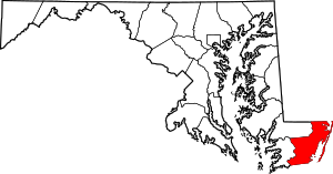 | |
| Towns | ||
| CDPs | ||
| Other communities | ||
| Footnotes | ‡This populated place also has portions in an adjacent county or counties | |
| Counties |  | |
|---|---|---|
| Principal city | ||
| Places 5k–20k | ||
| Places 1k–5k | ||
| Authority control |
|
|---|