Berkeley Heights, New Jersey
Berkeley Heights is a township in Union County, New Jersey, United States. As of the 2010 United States Census, the township's population was 13,183,[9][10][11] reflecting a decline of 224 (-1.7%) from the 13,407 counted in the 2000 Census, which had in turn increased by 1,427 (+11.9%) from the 11,980 counted in the 1990 Census.[21]
Berkeley Heights, New Jersey | |
|---|---|
| Township of Berkeley Heights | |
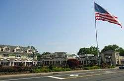 Heritage Square Shopping Center | |
 Seal | |
| Motto(s): "Where Tradition Meets Tomorrow." | |
 Map of Berkeley Heights in Union County. Inset: Location of Union County highlighted in the State of New Jersey. | |
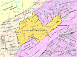 Census Bureau map of Berkeley Heights, New Jersey | |
| Coordinates: 40.676393°N 74.425027°W[1][2] | |
| Country | |
| State | |
| County | Union |
| Incorporated | November 8, 1809 (as New Providence Township) |
| Renamed | November 6, 1951 (as Berkeley Heights Township) |
| Named for | John Berkeley, 1st Baron Berkeley of Stratton |
| Government | |
| • Type | Faulkner Act (Mayor-Council-Administrator) |
| • Body | Township Council |
| • Mayor | Angie Devanney (Democratic Party, term ends December 31, 2022)[4][5] |
| • Administrator | Liza Viana[6] |
| • Municipal clerk | Ana P. Minkoff[7] |
| Area | |
| • Total | 6.266 sq mi (16.229 km2) |
| • Land | 6.211 sq mi (16.087 km2) |
| • Water | 0.055 sq mi (0.142 km2) 0.88% |
| Area rank | 252nd of 566 in state 6th of 21 in county[1] |
| Elevation | 394 ft (120 m) |
| Population | |
| • Total | 13,183 |
| • Estimate (2019)[13] | 13,363 |
| • Rank | 189th of 566 in state 15th of 21 in county[14] |
| • Density | 2,122.4/sq mi (819.5/km2) |
| • Density rank | 283rd of 566 in state 20th of 21 in county[14] |
| Time zone | UTC−05:00 (Eastern (EST)) |
| • Summer (DST) | UTC−04:00 (Eastern (EDT)) |
| ZIP Code | |
| Area code(s) | 908[17] |
| FIPS code | 3403905320[1][18][19] |
| GNIS feature ID | 0882218[1][20] |
| Website | Official site |

Berkeley Heights was originally incorporated as New Providence Township by the New Jersey Legislature on November 8, 1809, from portions of Springfield Township, while the area was still part of Essex County. New Providence Township became part of the newly formed Union County at its creation on March 19, 1857. Portions of the township were taken on March 23, 1869, to create Summit, and on March 14, 1899, to form the borough of New Providence. On November 6, 1951, the name of the township was changed to Berkeley Heights, based on the results of a referendum held that day.[22] The township was named for John Berkeley, 1st Baron Berkeley of Stratton, one of the founders of the Province of New Jersey.[23]
The township has been ranked as one of the state's highest-income communities. Based on data from the American Community Survey for 2013–2017, township residents had a median household income of $147,614, ranked 15th in the state among municipalities with more than 10,000 residents, almost double the statewide median of $76,475.[24]
In Money magazine's 2013 Best Places to Live rankings, Berkeley Heights was ranked 6th in the nation, the highest among the three places in New Jersey included in the top 50 list.[25][26] The magazine's 2007 list had the township ranked 45th out of a potential 2,800 places in the United States with populations above 7,500 and under 50,000.[27]
In its 2010 rankings of the "Best Places to Live", New Jersey Monthly magazine ranked Berkeley Heights as the 19th best place to live in New Jersey.[28] In its 2008 rankings of the "Best Places To Live" New Jersey Monthly magazine ranked Berkeley Heights as the 59th best place to live in New Jersey.[29]
History
The Lenape Native Americans were known to inhabit the region, including the area now known as Berkeley Heights, dating back to the 1524 voyage of Giovanni da Verrazzano to what is now the lower New York Bay.
The earliest construction in Berkeley Heights began in an area that is now part of the 1,960 acres (7.9 km2) Watchung Reservation, a Union County park that includes 305 acres (1.23 km2) of the township.[30]
The first European settler was Peter Willcox, who received a 424 acres (1.72 km2) land grant in 1720 from the Elizabethtown Associates. This group bought much of northern New Jersey from the Lenape in the late 17th century. Willcox built a grist and lumber mill across Green Brook.[31]
In 1793, a regional government was formed. It encompassed the area from present-day Springfield Township, Summit, New Providence, and Berkeley Heights, and was called Springfield Township. Growth continued in the area, and by 1809, Springfield Township divided into Springfield Township and New Providence Township, which included present day Summit, New Providence, and Berkeley Heights.[22]
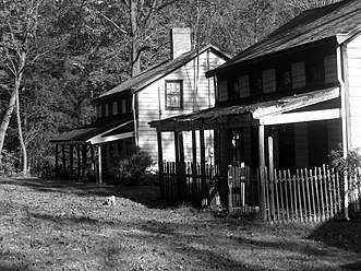
In 1845, Willcox's heirs sold the mill to David Felt, a paper manufacturer from New York. Felt built a small village around the mill aptly named Feltville. It included homes for workers and their families, dormitories, orchards, a post office and a general store with a second floor church.[31]
In 1860, Feltville was sold to sarsaparilla makers. Other manufacturing operations continued until Feltville went into bankruptcy in 1882. When residents moved away, the area became known as Deserted Village. Village remains consist of seven houses, a store, the mill and a barn. Deserted Village is listed on the National Register of Historic Places and is undergoing restoration by the Union County Parks Department. Restoration grants of almost $2 million were received from various state agencies.[32] Deserted Village, in the Watchung Reservation, is open daily for unguided walking tours during daylight hours.
On March 23, 1869, Summit Township (now the City of Summit) seceded from New Providence Township. On March 14, 1899, the Borough of New Providence seceded from New Providence Township. Present day Berkeley Heights remained as New Providence Township.[22] Many of the townships and regional areas in New Jersey were separating into small, locally governed communities at that time due to acts of the New Jersey Legislature that made it economically advantageous for the communities to due so.
Due to confusion between the adjacent municipalities of the Borough of New Providence and the Township of New Providence, the township conducted a referendum in 1952 and voted to change the name to Berkeley Heights Township. The origin of the township's name has never been fully established, but is believed to have been taken from an area of town that was referred to by this moniker, which itself was assumed to be derived from Lord John Berkeley, who was co-proprietor of New Jersey from 1664 to 1674.[33]
Early life in Berkeley Heights is documented in the Littell-Lord Farmhouse Museum & Farmstead (31 Horseshoe Road in Berkeley Heights), an 18-acre (73,000 m2) museum surrounding two houses, one of which was built in the 1750s and the other near the start of the 19th century.
Among the exhibits are a Victorian master bedroom and a Victorian children's room, furnished with period antiques. The children's room also has reproductions of antique toys, which visitors can play with. The museum, which is on the National Register of Historic Places, also includes an outbuilding that was used as a summer kitchen, a corn crib dating to the 19th century and a spring house built around a spring and used for refrigeration.[34] The museum is open 2-4 p.m. on the third Sunday of each month from April through December, or by appointment.
The township owes its rural character to its late development. Until 1941, when the American Telephone and Telegraph Company built the AT&T Bell Laboratories research facility in the township, it was a sleepy farming and resort community.[31]
Berkeley Heights is host to a traditional religious procession and feast carried out by members of Our Lady of Mt. Carmel Society. The feast is capped by one of the largest fireworks shows in the state. The Feast of Mt. Carmel has been a town tradition since 1909.[35]
In 1958, part of a Nike missile battery (NY-73) was installed in Berkeley Heights. The missiles were located in nearby Mountainside, while the radar station was installed in Berkeley Heights. It remained in operation until 1963, and remnants of the site are located adjacent to Governor Livingston High School.[36]
Free Acres
Another early Berkeley Heights community of note is the 67-acre (270,000 m2) Free Acres, established in 1910 by Bolton Hall, a New York entrepreneur and reformer who believed in the idea of Henry George, the economist, of single taxation, under which residents pay tax to the community, which, in turn, pays a lump sum to the municipality. Among the early residents of Free Acres were the actor James Cagney and his wife, Billie.[31]
Residents of Free Acres pay tax to their association, which maintains its streets and swimming pool, approves architectural changes to homes and pays a lump sum in taxes to the municipality.[31]
Geography
According to the United States Census Bureau, the township had a total area of 6.266 square miles (16.229 km2), including 6.211 square miles (16.087 km2) of land and 0.055 square miles (0.142 km2) of water (0.88%).[1][2] Certain portions of Berkeley Heights are located in various flood zones.
The township is located partially on the crest of the Second Watchung Mountain and in the Passaic River Valley, aptly named as the Passaic River forms the township's northern border. Berkeley Heights is located in northwestern Union County, at the confluence of Union, Morris, and Somerset Counties. Berkeley Heights is bordered by New Providence and Summit to the east, Scotch Plains to the southeast, Chatham to the north, Watchung to the south, and Warren Township and Long Hill Township to the west.[37][38][39]
Unincorporated communities, localities and place names located partially or completely within the township include Benders Corners, Glenside Park, Stony Hill and Union Village.[40]
Downtown
Downtown Berkeley Heights is located along Springfield Avenue, approximately between the intersections with Plainfield Avenue and Snyder Avenue. Downtown is home to more than 20 restaurants which join with the Downtown Beautification Committee to hold an annual Restaurant Week each September.[41] In addition, a post office, the Municipal Building, police station, train station, Walgreens, CVS, Stop & Shop and other shops and services are located in this downtown section.
A brick walk with personalized bricks engraved with the names of many long-time Berkeley Heights residents runs from near the railroad station towards the planned Stratton House development, at the site of the former Kings. A memorial to the victims of the September 11 terrorist attacks adjoins a wooded area alongside Park Avenue, just southwest of downtown.[42]
Certain portions of Berkeley Heights are located in flood zones. Residential homes, as well as some commercial areas along the downtown Springfield Avenue area, are impacted by flooding.[43]
Demographics
| Historical population | |||
|---|---|---|---|
| Census | Pop. | %± | |
| 1810 | 756 | — | |
| 1820 | 768 | 1.6% | |
| 1830 | 903 | 17.6% | |
| 1840 | 832 | −7.9% | |
| 1850 | 1,216 | 46.2% | |
| 1860 | 1,308 | 7.6% | |
| 1870 | 934 | * | −28.6% |
| 1880 | 781 | −16.4% | |
| 1890 | 839 | 7.4% | |
| 1900 | 469 | * | −44.1% |
| 1910 | 526 | 12.2% | |
| 1920 | 954 | 81.4% | |
| 1930 | 1,899 | 99.1% | |
| 1940 | 2,194 | 15.5% | |
| 1950 | 3,466 | 58.0% | |
| 1960 | 8,721 | 151.6% | |
| 1970 | 13,078 | 50.0% | |
| 1980 | 12,549 | −4.0% | |
| 1990 | 11,980 | −4.5% | |
| 2000 | 13,407 | 11.9% | |
| 2010 | 13,183 | −1.7% | |
| Est. 2019 | 13,363 | [13][44][45] | 1.4% |
| Population sources:1810-1920[46] 1840[47] 1850[48] 1860-1870[49] 1870[50] 1880-1890[51] 1890-1910[52] 1910-1930[53] 1930-1990[54] 2000[55][56] 2010[9][10][11] * = Lost territory in previous decade.[22] | |||
2010 Census
The 2010 United States Census counted 13,183 people, 4,470 households, and 3,580.470 families in the township. The population density was 2,122.4 per square mile (819.5/km2). There were 4,596 housing units at an average density of 739.9 per square mile (285.7/km2). The racial makeup of the township was 85.64% (11,290) White, 1.49% (197) Black or African American, 0.02% (3) Native American, 10.43% (1,375) Asian, 0.00% (0) Pacific Islander, 0.75% (99) from other races, and 1.66% (219) from two or more races. Hispanic or Latino of any race were 5.12% (675) of the population.[9]
The 4,470 households accounted 41.7% with children under the age of 18 living with them; 71.1% were married couples living together; 6.5% had a female householder with no husband present, and 19.9% were non-families. Of all households, 17.6% were made up of individuals, and 10.4% had someone living alone who was 65 years of age or older. The average household size was 2.85 and the average family size was 3.26.[9]
In the township, the population age was spread out with 26.9% under the age of 18, 5.2% from 18 to 24, 20.5% from 25 to 44, 30.0% from 45 to 64, and 17.5% who were 65 years of age or older. The median age was 43.5 years. For every 100 females, the population had 90.6 males. For every 100 females ages 18 and older there were 87.5 males.[9]
The Census Bureau's 2006-2010 American Community Survey showed that (in 2010 inflation-adjusted dollars) median household income was $132,089 (with a margin of error of +/- $11,331) and the median family income was $150,105 (+/- $17,689). Males had a median income of $105,733 (+/- $10,158) versus $55,545 (+/- $11,985) for females. The per capita income for the township was $56,737 (+/- $5,135). About 0.8% of families and 1.4% of the population were below the poverty line, including 1.7% of those under age 18 and 0.7% of those age 65 or over.[57]
2000 Census
As of the 2000 United States Census[18] there were 13,407 people, 4,479 households, and 3,717 families residing in the township. The population density was 2,140.7 people per square mile (826.9/km2). There were 4,562 housing units at an average density of 728.4 per square mile (281.4/km2). The racial makeup of the township was 89.65% White, 1.11% African American, 0.08% Native American, 7.87% Asian, 0.61% from other races, and 0.68% from two or more races. Hispanic or Latino of any race were 3.68% of the population.[55][56]
There were 4,479 households out of which 41.5% had children under the age of 18 living with them, 74.1% were married couples living together, 6.9% had a female householder with no husband present, and 17.0% were non-families. 14.8% of all households were made up of individuals and 7.5% had someone living alone who was 65 years of age or older. The average household size was 2.89 and the average family size was 3.21.[55][56]

In the township the population was spread out with 26.8% under the age of 18, 4.2% from 18 to 24, 27.8% from 25 to 44, 24.8% from 45 to 64, and 16.4% who were 65 years of age or older. The median age was 40 years. For every 100 females, there were 91.0 males. For every 100 females age 18 and over, there were 87.4 males.[55][56]
The median income for a household in the township was $107,716, and the median income for a family was $118,862. Males had a median income of $83,175 versus $50,022 for females. The per capita income for the township was $43,981. About 1.5% of families and 2.1% of the population were below the poverty line, including 1.8% of those under age 18 and 3.1% of those age 65 or over.[55][56]
Economy
Berkeley Heights is home to the Murray Hill Bell Labs headquarters of Nokia. The transistor, solar cell, and laser were invented in this facility when it was part of AT&T.
Berkeley Heights is also home to L'Oréal USA's New Jersey headquarters.[58]
In 2003, Summit Medical Group signed a lease[59] to build its main campus on the site of the former D&B Corporation headquarters located on Diamond Hill Road. Today, the 100-year-old medical group has more than 800 doctors.[60]
Parks and recreation

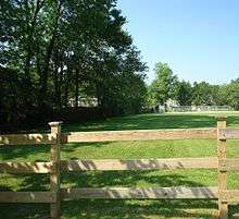
Located in Berkeley Heights are many municipal parks, including the largest one, Columbia Park (located along Plainfield Avenue). Columbia Park boasts tennis courts, two baseball fields, basketball courts, and a large children's play area. It is operated by the Recreation Commission. In addition to those located at each of the schools, athletic fields are located along Horseshoe Road (Sansone Field) and along Springfield Avenue (Passaic River Park).
There are three swimming clubs located in Berkeley Heights: the Berkeley Heights Community Pool (Locust Avenue), the Berkeley Swim Club (behind Columbia Park), and Berkeley Aquatic (off of Springfield Avenue).
The Watchung Reservation and Passaic River Parkway are in the township and maintained by Union County. The Watchung Reservation has hiking trails, horseback riding trails, a large lake (Lake Surprise), the deserted community of Feltville and picnic areas.[61]
Government
Local government
In accordance with a ballot question that was passed in November 2005, Berkeley Heights switched from a Township Committee form to a Mayor-Council-Administrator form of government under the Faulkner Act.[3] The switch took effect on January 1, 2007. In the fall 2006 elections all seats were open. Under the new form of government, the mayor is directly elected to a four-year term. The Township Committee has been replaced with a Township Council consisting of six members elected to staggered, three-year terms. With all six Township Council seats open in 2006, two councilpersons were elected to one-year terms, after which those seats were open for three-year terms in 2007. Two other seats were open for two-year terms in 2006. The final two were open for three-year terms from the beginning. The responsibilities of the Township Administrator are unchanged.[62]
As of 2020, the Mayor of Berkeley Heights is Democrat Angie D. Devanney, whose term of office ends on December 31, 2022.[4] Members of the Township Council are Council President Alvaro Medeiros (D, 2021), Council Vice President Susan Poage (D, 2020), Gentiana Brahimaj (R, 2022), Manuel Couto (R, 2022), Jeanne Kingsley (R, 2020) and Stephen H. Yellin (D, 2021).[63][64][65][66][67][68]
The Council President serves as Acting Mayor in the Mayor's absence; the Council Vice President serves as Acting Mayor in the absence of both the Mayor and the Council President.
The Berkeley Heights Municipal Building is located at 29 Park Avenue. A new Municipal Complex is under construction at the same location.
Federal, State and County Representation
Berkeley Heights is located in the 7th Congressional District[69] and is part of New Jersey's 21st state legislative district.[10][70][71]
For the 116th United States Congress. New Jersey's Seventh Congressional District is represented by Tom Malinowski (D, Ringoes).[72] New Jersey is represented in the United States Senate by Democrats Cory Booker (Newark, term ends 2021)[73] and Bob Menendez (Paramus, term ends 2025).[74][75]
For the 2018–2019 session (Senate, General Assembly), the 21st Legislative District of the New Jersey Legislature is represented in the State Senate by Thomas Kean Jr. (R, Westfield) and in the General Assembly by Jon Bramnick (R, Westfield) and Nancy Munoz (R, Summit).[76][77]
Union County is governed by a Board of Chosen Freeholders, whose nine members are elected at-large to three-year terms of office on a staggered basis with three seats coming up for election each year, with an appointed County Manager overseeing the day-to-day operations of the county. At an annual reorganization meeting held in the beginning of January, the board selects a Chair and Vice Chair from among its members.[78] As of 2019, Union County's Freeholders are Chair Bette Jane Kowalski (D, Cranford, term ends December 31, 2019),[79] Vice Chair Alexander Mirabella (D, Fanwood, 2021)[80] Angel G. Estrada (D, Elizabeth, 2020),[81] Angela R. Garretson (D, Hillside Township, 2020),[82] Sergio Granados (D, Elizabeth, 2019),[83] Christopher Hudak (D, Linden, term ends December 31, 2020),[84] Kimberly Palmieri-Mouded (D, Westfield, 2021),[85] Andrea Staten (D, Roselle, 2021),[86] and Rebecca Williams (D, Plainfield, 2019).[87] Constitutional officers elected on a countywide basis are County Clerk Joanne Rajoppi (D, Union, 2020),[88] Sheriff Peter Corvelli (D, Kenilworth, 2020)[89] and Surrogate James S. LaCorte (D, Springfield Township, 2019).[90] The County Manager is Edward Oatman.
Politics
As of May 18, 2017, there were a total of 9,558 registered voters in Berkeley Heights Township, of which 2,387 (25.0% vs. 45.2% countywide) were registered as Democrats, 3,368 (35.2% vs. 14.9%) were registered as Republicans and 3,780 (39.5% vs. 39.4%) were registered as Unaffiliated. There were 23 voters registered to other parties.[91] Among the township's 2010 Census population, 68.8% (vs. 53.3% in Union County) were registered to vote, including 94.2% of those ages 18 and over (vs. 70.6% countywide).[92][93]
In the 2016 presidential election, Democrat Hillary Clinton received 3,482 votes (48.23% vs. 65.94% countywide), ahead of Republican Donald Trump with 3,359 votes (46.53% vs. 30.47% countywide), and other candidates with 378 votes (5.1% vs 3.6% countywide) among the 7,325 ballots cast by the township's 9,775 voters, for a turnout of 74.9%[94][95]
In the 2012 presidential election, Republican Mitt Romney received 3,897 votes (57.3% vs. 32.3% countywide), ahead of Democrat Barack Obama with 2,799 votes (41.1% vs. 66.0%) and other candidates with 76 votes (1.1% vs. 0.8%), among the 6,802 ballots cast by the township's 9,400 registered voters, for a turnout of 72.4% (vs. 68.8% in Union County).[96][97] In the 2008 presidential election, Republican John McCain received 4,011 votes (55.3% vs. 35.2% countywide), ahead of Democrat Barack Obama with 3,094 votes (42.7% vs. 63.1%) and other candidates with 93 votes (1.3% vs. 0.9%), among the 7,248 ballots cast by the township's 9,375 registered voters, for a turnout of 77.3% (vs. 74.7% in Union County).[98] In the 2004 presidential election, Republican George W. Bush received 4,146 votes (57.1% vs. 40.3% countywide), ahead of Democrat John Kerry with 3,019 votes (41.6% vs. 58.3%) and other candidates with 60 votes (0.8% vs. 0.7%), among the 7,258 ballots cast by the township's 9,121 registered voters, for a turnout of 79.6% (vs. 72.3% in the whole county).[99]
In the 2013 gubernatorial election, Republican Chris Christie received 72.2% of the vote (3,145 cast), ahead of Democrat Barbara Buono with 26.4% (1,150 votes), and other candidates with 1.4% (63 votes), among the 4,457 ballots cast by the township's 9,193 registered voters (99 ballots were spoiled), for a turnout of 48.5%.[100][101] In the 2009 gubernatorial election, Republican Chris Christie received 3,136 votes (60.0% vs. 41.7% countywide), ahead of Democrat Jon Corzine with 1,589 votes (30.4% vs. 50.6%), Independent Chris Daggett with 409 votes (7.8% vs. 5.9%) and other candidates with 32 votes (0.6% vs. 0.8%), among the 5,223 ballots cast by the township's 9,201 registered voters, yielding a 56.8% turnout (vs. 46.5% in the county).[102]
Education
Public schools
The Berkeley Heights Public Schools serves students in pre-kindergarten through twelfth grade.[103] As of the 2017–18 school year, the district and its six schools had an enrollment of 2,634 students and 223.8 classroom teachers (on an FTE basis), for a student–teacher ratio of 11.8:1.[104] Schools in the district (with 2017-18 enrollment data from the National Center for Education Statistics[105]) are Mary Kay McMillin Early Childhood Center[106] (327 students; in PreK-1st grade), Thomas P. Hughes Elementary School[107] (270; 2-5), Mountain Park Elementary School[108] (228; 2-5), William Woodruff Elementary School[109] (209; 2-5), Columbia Middle School[110] (566; 6-8) and Governor Livingston High School[111] (1,024; 9-12).[112]
The district's high school serves public school students of Berkeley Heights, along with approximately 300 students from neighboring Borough of Mountainside who are educated at the high school as part of a sending/receiving relationship with the Mountainside School District that is covered by an agreement that runs through the end of 2021–22 school year.[113][114] Governor Livingston provides programs for deaf, hard of hearing and cognitively-impaired students in the district and those who are enrolled from all over north-central New Jersey who attend on a tuition basis.[115]
Governor Livingston was the 30th-ranked public high school in New Jersey out of 305 schools statewide in New Jersey Monthly magazine's September 2018 cover story on the state's "Top Public High Schools".[116]
Private schools
There are four private pre-kindergarten schools in Berkeley Heights. The Westminster Nursery School is located at the corner of Plainfield Avenue and Mountain Avenue, the Union Village Nursery is located bordering Warren Township at the corner of Mountain Avenue and Hillcrest Road, the Diamond Hill Montessori is located along Diamond Hill Road opposite McMane Avenue and Primrose on Springfield Avenue.[117]
FlexSchool, a private school for twice-exceptional and gifted fifth through twelfth graders, is the only private secondary school in Berkeley Heights.[118]
Infrastructure
Transportation
Roads and highways
_between_Exit_41_and_Exit_43_in_Berkeley_Heights_Township%2C_Union_County%2C_New_Jersey.jpg)
As of May 2010, the township had a total of 65.73 miles (105.78 km) of roadways, of which 50.46 miles (81.21 km) were maintained by the municipality, 12.11 miles (19.49 km) by Union County and 3.16 miles (5.09 km) by the New Jersey Department of Transportation.[119]
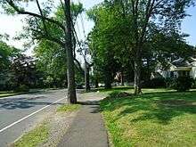
The most significant highway serving Berkeley Heights is Interstate 78, which runs from New York City to Pennsylvania. Other major roads in Berkeley Heights include Springfield Avenue, Mountain Avenue, Snyder Avenue, Plainfield Avenue, and Park Avenue. Springfield Avenue and Mountain Avenue run east–west, Snyder Avenue and Plainfield Avenue run north–south, while Park Avenue runs northeast–southwest. Each of these roads is heavily residential (except parts of Springfield Avenue) with only one travel lane in each direction.
Public transportation
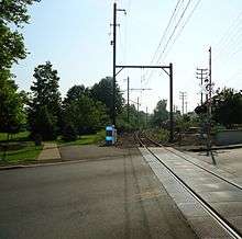

NJ Transit provide service at the Berkeley Heights station[120] serving Hoboken Terminal, Newark Broad Street Station, and Penn Station in Midtown Manhattan as part of the Gladstone Branch. Berkeley Heights is also in close proximity of the Summit train station, which provides frequent commuter rail service to New York City.
NJ Transit offers local bus service on the 986 route.[121] Lakeland Bus Lines also provides commuter bus service to the Port Authority Bus Terminal in Midtown Manhattan and a connection to Gladstone.
Freight rail transportation had been provided by Norfolk Southern via off-peak use of New Jersey Transit's Gladstone Branch line until a final run on November 7, 2008, after 126 years of service. The Berkeley Heights plant of Reheis Chemical located on Snyder Avenue was the last freight customer on the Gladstone Branch, receiving shipments of hydrochloric acid.[122]
Newark Liberty International Airport is approximately 18 miles (29 km) east of Berkeley Heights.
Healthcare
The Summit Medical Group, located on Mountain Avenue, is the main medical facility in Berkeley Heights.[123]
Public library
Originally opened in 1949, Berkeley Heights Public Library closed its doors to the public at its 290 Plainfield Avenue location. It was moved to a temporary home at 110 Roosevelt Avenue, otherwise known as the Little Flower Church Rectory.[124] The library is a member of the Infolink region of libraries, the Morris Union Federation (MUF) and the Middlesex Union Reciprocal Agreement Libraries (MURAL).[125]
Police, fire, and emergency services

The Berkeley Heights Police Department is located at the Municipal Building, 29 Park Avenue.[126] This is also the location of the Berkeley Heights Municipal Court.
The Berkeley Heights Volunteer Rescue Squad, founded in 1942, is located at the corner of Snyder Avenue and Locust Avenue. The closest trauma centers are Morristown Medical Center (in Morristown) and University Hospital in Newark. The closest hospital emergency room is Overlook Hospital in Summit. The all-volunteer Rescue Squad provides emergency medical services to the township seven days per week. As of April 2019, the squad had 60 riding members including college and high school students of which 32 are certified EMTs. In 2018, the squad responded to nearly 800 calls.
The Berkeley Heights Fire Department is a volunteer fire department that is responsible for preserving life, property and the environment for a population of more than thirteen thousand in an area that is six and half square miles. The fire department is commanded by Chief Anthony Padovano. In addition to fire suppression, the department has members trained to respond to technical rescue and hazardous materials releases. The Department also works to continually educate the public in fire, life safety and disaster preparedness, along with enforcing life safety codes.
Since its inception in 1928 the fire department is staffed by members of Berkeley Heights Volunteer Fire Company # 1. Two prior attempts at organizing a fire department failed, first being the Berkeley Heights Hook & Ladder Co # 1 in 1912, and then the Berkeley Heights Chemical Co in 1926.
In 2018 the Fire Department responded to 633 fires, emergencies and calls for assistance. 31 of these calls were to fires with no fatalities or injuries. Estimated loss due to fire was $584,671.00. Estimated total value that was saved was $16,755,671. 83 total responses to rescue and emergency medical incidents, which include motor vehicle collisions with people trapped and rescue of people in stalled elevators. 59 hazardous materials responses which include carbon monoxide emergencies, natural gas and propane releases and other chemical releases and spills. Berkeley Heights Fire Dept assisted other communities 49 times with mutual aid at major fires, emergencies and providing cover assignments.
Notable people
People who were born in, residents of, or otherwise closely associated with Berkeley Heights include:
- Al Aronowitz (1928–2005), rock journalist who claimed that Bob Dylan wrote his famous "Mr. Tambourine Man" in Aronowitz's former Berkeley Heights home.[127]
- Steve Balboni (born 1957), former New York Yankee.[128]
- BEDlight for BlueEYES, an alternative rock band.[129]
- Dennis Boutsikaris (born 1952), actor.[130][131]
- James Cagney (1899–1986), actor who resided in Free Acres.[31]
- David Cantor (born 1954), actor.[132]
- John Carlini, jazz guitarist.[133]
- Ronald Chen (born 1958), former Public Advocate of New Jersey, nominated to fill the position on January 5, 2006, by Governor of New Jersey Jon Corzine.[134]
- Christopher Durang (born 1949), playwright and actor.[135]
- Cathy Engelbert (born 1965), CEO of Deloitte, first female CEO of a major U.S. accounting firm.[136]
- Lauren Beth Gash (born 1960), lawyer and politician who served in the Illinois House of Representatives from 1993 to 2001.[137]
- Gina Genovese (born 1959), businesswoman and politician who has served as mayor of Long Hill Township.[138]
- Scott M. Gimple (born 1971), television and comic book writer.[139]
- Bolton Hall (1854–1938), founder of Free Acres.[31]
- MacKinlay Kantor (1904–1977), screenwriter and novelist, formerly resided in Free Acres.[140]
- Harry Kelly (1871–1953), anarchist.[140]
- Victor Kilian (1891–1979), actor.[140]
- P. F. Kluge (born 1942), novelist.[141]
- Mary Jo Kopechne (1940–1969), political aide who drowned off Chappaquiddick Island when Senator Ted Kennedy (D-Mass.) drove his car off a bridge on July 18, 1969.[142]
- Brielle LaCosta (born 1984), Miss New Jersey International 2010 and Miss East Coast 2014.[143]
- John R. Pierce (1910–2002), communications engineer, scientist, and father of the communications satellite.[144][145]
- Juliette Reilly (born 1993), singer and YouTube personality.[146]
- Dennis Ritchie (1941–2011), creator of the C programming language and co-inventor of the UNIX operating system.[147]
- Bertha Runkle (1879–1958), novelist and playwright.[148]
- Peter Sagal (born 1965), playwright, screenwriter, actor, and host of the National Public Radio game show Wait Wait... Don't Tell Me!.[149]
- Jill Santoriello, playwright and author of the new Broadway musical A Tale of Two Cities, graduated from Governor Livingston High School.[150]
- Thorne Smith (1892–1934), author.[140]
- Zenon Snylyk (1923–2002), soccer player.[151]
References
- 2010 Census Gazetteer Files: New Jersey Places, United States Census Bureau. Accessed May 21, 2015.
- US Gazetteer files: 2010, 2000, and 1990, United States Census Bureau. Accessed September 4, 2014.
- 2011 New Jersey Legislative District Data Book, Rutgers University Edward J. Bloustein School of Planning and Public Policy, June 2012, p. 95.
- Mayor, Berkeley Heights Township. Accessed March 19, 2020.
- 2020 New Jersey Mayors Directory, New Jersey Department of Community Affairs. Accessed February 1, 2020.
- Administration, Berkeley Heights, NJ. Accessed March 19, 2020.
- Township Clerk, Berkeley Heights, NJ. Accessed March 19, 2020.
- U.S. Geological Survey Geographic Names Information System: Township of Berkeley Heights, Geographic Names Information System. Accessed March 4, 2013.
- DP-1 - Profile of General Population and Housing Characteristics: 2010 for Berkeley Heights township, Union County, New Jersey, United States Census Bureau. Accessed May 7, 2012.
- Municipalities Sorted by 2011-2020 Legislative District, New Jersey Department of State. Accessed February 1, 2020.
- Table DP-1. Profile of General Demographic Characteristics: 2010 for Berkeley Heights township Archived 2014-04-24 at the Wayback Machine, New Jersey Department of Labor and Workforce Development. Accessed May 7, 2012.
- 2010 Census Populations: Union County, Asbury Park Press. Accessed June 5, 2011.
- QuickFacts for Berkeley Heights township, Union County, New Jersey; Union County, New Jersey; New Jersey from Population estimates, July 1, 2019, (V2019), United States Census Bureau. Accessed May 21, 2020.
- GCT-PH1 Population, Housing Units, Area, and Density: 2010 - State -- County Subdivision from the 2010 Census Summary File 1 for New Jersey , United States Census Bureau. Accessed December 11, 2012.
- Look Up a ZIP Code for Berkeley Heights, NJ, United States Postal Service. Accessed March 26, 2012.
- ZIP Codes, State of New Jersey. Accessed August 26, 2013.
- Area Code Lookup - NPA NXX for Berkeley Heights, NJ, Area-Codes.com. Accessed February 10, 2015.
- U.S. Census website , United States Census Bureau. Accessed September 4, 2014.
- Geographic Codes Lookup for New Jersey, Missouri Census Data Center. Accessed June 20, 2012.
- US Board on Geographic Names, United States Geological Survey. Accessed September 4, 2014.
- Table 7. Population for the Counties and Municipalities in New Jersey: 1990, 2000 and 2010, New Jersey Department of Labor and Workforce Development, February 2011. Accessed June 20, 2012.
- Snyder, John P. The Story of New Jersey's Civil Boundaries: 1606-1968, Bureau of Geology and Topography; Trenton, New Jersey; 1969. p. 237. Accessed May 7, 2012.
- Hutchinson, Viola L. The Origin of New Jersey Place Names, New Jersey Public Library Commission, May 1945. Accessed August 27, 2015.
- Raychaudhuri, Disha. "The wealthiest towns in N.J., ranked", NJ Advance Media for NJ.com, June 7, 2019. Accessed November 4, 2019. "The median household income in N.J. is $76,475, recent Census data shows.... A note about the data: The data comes from 2013-2017 American Community Survey conducted by U.S. Census Bureau. Smaller towns with less than 10,000 residents were excluded from the list.... 15. Berkeley Heights, Union County Median income: $147,614"
- Staff. "2013 Best Places to Live; America's best small towns", CNN / Money (magazine), September 2013. Accessed August 12, 2013.
- Staff. 2013 Best Places to Live -6. Berkeley Heights, NJ Archived September 4, 2013, at the Wayback Machine, CNN / Money (magazine), September 2013. Accessed August 12, 2013.
- Staff. Best Places to Live: Top 100 - 45. Berkeley Heights, N.J. Archived August 10, 2007, at the Wayback Machine, Money (magazine). Accessed August 12, 2013.
- "Best Places To Live 2010, New Jersey Monthly, February 11, 2010. Accessed July 3, 2011.
- "Best Places To Live - The Complete Top Towns List 1-100" Archived 2009-05-25 at the Wayback Machine, New Jersey Monthly, February 21, 2008. Accessed May 11, 2009.
- Watchung Reservation, United States Geological Survey. Accessed May 7, 2012.
- Cheslow, Jerry. "If You're Thinking of Living In / Berkeley Heights, N.J.; Quiet Streets Near River and Mountain", The New York Times, October 11, 1998. Accessed February 27, 2011. "Among the early residents of Free Acres were the actor James Cagney and his wife, Billie."
- Friedman, Alexi. "Union County approves $1.4M in renovations for historic barn", The Star-Ledger, July 31, 2009. Accessed July 3, 2011. "Union County Freeholders approved a $1.4 million contract to renovate a historic but dilapidated barn in the Watchung Reservation in an area known as the Deserted Village of Feltville/Glenside Park."
- Hangout: A Short History of New Jersey - Colonial Times, State of New Jersey. Accessed July 3, 2011.
- NEW JERSEY - Union County, National Register of Historic Places. Accessed July 3, 2011.
- Ness, Tracy. "Feast of Mt. Carmel this week in Berkeley Heights", Independent Press, July 12, 2010. Accessed June 17, 2015. "Our Lady of Mt. Carmel Society was founded in 1909 in Berkeley Heights and celebrates annually on July 16, the Saint's day. 2009 celebrates 100 years of tradition."
- Harpster, Frank. "Missiles in Mountainside — Nike Battery NY-73", from The Hetfield House of the Mountainside Historic Preservation Committee, November 2009. Accessed June 17, 2015. "Nike NY-73 had two parts. The launcher was in Mountainside at the entrance from Summit Lane.... The second part was located in Berkeley Heights on the hilltop next to Governor Livingston High School – this was the Missile Tracking Radar Station."
- Areas touching Berkeley Heights, MapIt. Accessed March 19, 2020.
- Union County Municipal Profiles, Union County, New Jersey. Accessed March 19, 2020.
- New Jersey Municipal Boundaries, New Jersey Department of Transportation. Accessed November 15, 2019.
- Locality Search, State of New Jersey. Accessed May 22, 2015.
- https://www.tapinto.net/towns/berkeley-heights/articles/meet-around-the-table-during-berkeley-heights-restaurant-week-september-9-16-2018
- Berkeley Heights 9/11 Memorial, Living Memorial. Accessed July 18, 2017.
- Township of Berkeley Heights; and Passaic River Coalition. Natural Resources Inventory, p. 29. Township of Berkeley Heights, 2005. Accessed July 2, 2015.
- Annual Estimates of the Resident Population for Minor Civil Divisions in New Jersey: April 1, 2010 to July 1, 2019, United States Census Bureau. Accessed May 21, 2020.
- Census Estimates for New Jersey April 1, 2010 to July 1, 2019, United States Census Bureau. Accessed May 21, 2020.
- Compendium of censuses 1726-1905 : together with the tabulated returns of 1905, New Jersey Department of State, 1906. Accessed May 5, 2013.
- Bowen, Francis. American Almanac and Repository of Useful Knowledge for the Year 1843, p. 231, David H. Williams, 1842. Accessed May 5, 2013. Population is listed as 833.
- Debow, James Dunwoody Brownson. The Seventh Census of the United States: 1850, p. 138. R. Armstrong, 1853. Accessed May 5, 2013.
- Raum, John O. The History of New Jersey: From Its Earliest Settlement to the Present Time, Volume 1, p. 281, J. E. Potter and company, 1877. Accessed May 5, 2013. "New Providence in 1860 had a population of 1,308, and in 1870, 934."
- Staff. A compendium of the ninth census, 1870, p. 261. United States Census Bureau, 1872. Accessed May 5, 2013.
- Porter, Robert Percival. Preliminary Results as Contained in the Eleventh Census Bulletins: Volume III - 51 to 75, p. 99. United States Census Bureau, 1890. Accessed May 5, 2013.
- Thirteenth Census of the United States, 1910: Population by Counties and Minor Civil Divisions, 1910, 1900, 1890, United States Census Bureau, p. 339. Accessed May 5, 2013.
- Fifteenth Census of the United States : 1930 - Population Volume I, United States Census Bureau, p. 719. Accessed May 5, 2013.
- Table 6. New Jersey Resident Population by Municipality: 1930 - 1990, New Jersey Department of Labor and Workforce Development. Accessed August 9, 2016.
- Census 2000 Profiles of Demographic / Social / Economic / Housing Characteristics for Berkeley Heights township, New Jersey Archived 2004-01-13 at the Wayback Machine, United States Census Bureau. Accessed May 5, 2013.
- DP-1: Profile of General Demographic Characteristics: 2000 - Census 2000 Summary File 1 (SF 1) 100-Percent Data for Berkeley Heights township, Union County, New Jersey, United States Census Bureau. Accessed May 5, 2013.
- DP03: Selected Economic Characteristics from the 2006-2010 American Community Survey 5-Year Estimates for Berkeley Heights township, Union County, New Jersey, United States Census Bureau. Accessed May 7, 2012.
- O'Neill, Erin Eileen. "L'Oreal moves into 'second headquarters' in Berkeley Heights", The Star Ledger, September 30, 2009. Accessed July 3, 2011. "L'Oréal has nearly completed consolidating a handful of its New Jersey operations into a new Berkeley Heights office complex near Route 78. The 156,000 square-foot facility, located in the Connell Corporate Park, can accommodate about 600 employees. More than 400 staff members from L'Oréal USA's offices in Clark, Cranbury, Cranford, South Brunswick and Westfield, as well as some employees from the cosmetic giant's U.S. headquarters in Manhattan, are working on the color-themed floors of the four-story building."
- https://www.nytimes.com/2003/06/15/realestate/commercial-property-new-jersey-murray-hill-office-park-to-become-medical-campus.html
- https://www.summitmedicalgroup.com/about/Our_History/
- Watchung Reservation Trail Map, Department of Parks, Recreation & Facilities, Union County, New Jersey. Accessed May 5, 2013.
- Levoy, Laurie. "Five battle it out in Berkeley Heights primaries", Courier News, May 15, 2009. Accessed June 5, 2011. "The municipality changed its governance in January 2007 to a mayor-council-administrator form after residents voted for the change in the November 2006 election."
- Township Council, Berkeley Heights Township. Accessed March 19, 2020. "The Township of Berkeley Heights is governed by the Mayor /Council / Administrator form of local government. Term Overview: As a variant of the Faulkner Act, the Mayor is directly elected by the voters and serves a term of four years. Council members are elected to serve three year terms. Council terms are staggered so that two Council seats are up for election each year."
- 2019 Municipal Data Sheet, Berkeley Heights Township. Accessed September 10, 2019.
- Elected Officials, Union County, New Jersey Clerk. Accessed March 19, 2020.
- General Election November 5, 2019 Official Results, Union County, New Jersey, updated December 5, 2019. Accessed January 1, 2020.
- General Election November 6, 2018 Official Results, Union County, New Jersey, updated November 16, 2018. Accessed January 1, 2019.
- General Election November 7, 2017 Official Results, Union County, New Jersey, updated November 13, 2017. Accessed January 1, 2018.
- Plan Components Report, New Jersey Redistricting Commission, December 23, 2011. Accessed February 1, 2020.
- 2019 New Jersey Citizen's Guide to Government, New Jersey League of Women Voters. Accessed October 30, 2019.
- Districts by Number for 2011-2020, New Jersey Legislature. Accessed January 6, 2013.
- Directory of Representatives: New Jersey, United States House of Representatives. Accessed June 1, 2020.
- About Cory Booker, United States Senate. Accessed January 26, 2015. "He now owns a home and lives in Newark's Central Ward community."
- Biography of Bob Menendez, United States Senate, January 26, 2015. "He currently lives in Paramus and has two children, Alicia and Robert."
- Senators of the 116th Congress from New Jersey. United States Senate. Accessed April 17, 2019. "Booker, Cory A. - (D - NJ) Class II; Menendez, Robert - (D - NJ) Class I"
- Legislative Roster 2018-2019 Session, New Jersey Legislature. Accessed January 22, 2018.
- District 21 Legislators, New Jersey Legislature. Accessed January 22, 2018.
- , Union County, New Jersey. Accessed May 6, 2019.
- , Union County, New Jersey. Accessed May 6, 2019.
- , Union County, New Jersey. Accessed May 6, 2019.
- , Union County, New Jersey. Accessed May 6, 2019.
- , Union County, New Jersey. Accessed May 6, 2019.
- , Union County, New Jersey. Accessed May 6, 2019.
- , Union County, New Jersey. Accessed May 6, 2019.
- , Union County, New Jersey. Accessed May 6, 2019.
- , Union County, New Jersey. Accessed May 6, 2019.
- , Union County, New Jersey. Accessed May 5, 2019.
- , Union County, New Jersey. Accessed May 6, 2019.
- , Union County, New Jersey. Accessed May 6, 2019.
- , Union County, New Jersey. Accessed May 6, 2019.
- Voter Registration Summary - Union, New Jersey Department of State Division of Elections, March 23, 2011. Accessed May 4, 2013.
- GCT-P7: Selected Age Groups: 2010 - State -- County Subdivision; 2010 Census Summary File 1 for New Jersey , United States Census Bureau. Accessed May 4, 2013.
- "Union County Official Results 11/08/2016". Clarity Elections.
- "Number of Registered Voters and Ballots Cast" (PDF). NJ.gov.
- Presidential November 6, 2012 General Election Results – Union County Archived February 1, 2014, at the Wayback Machine, New Jersey Department of State Division of Elections, March 15, 2013. Accessed May 5, 2013.
- Number of Registered Voters and Ballots Cast November 6, 2012 General Election Results – Union County, New Jersey Department of State Division of Elections, March 15, 2013. Accessed May 5, 2013.
- 2008 Presidential General Election Results: Union County, New Jersey Department of State Division of Elections, December 23, 2008. Accessed May 4, 2013.
- 2004 Presidential Election: Union County, New Jersey Department of State Division of Elections, December 13, 2004. Accessed May 4, 2013.
- "Governor - Union County" (PDF). New Jersey Department of Elections. January 29, 2014. Retrieved December 24, 2014.
- "Number of Registered Voters and Ballots Cast - November 5, 2013 - General Election Results - Union County" (PDF). New Jersey Department of Elections. January 29, 2014. Retrieved December 24, 2014.
- 2009 Governor: Union County Archived 2012-10-17 at the Wayback Machine, New Jersey Department of State Division of Elections, December 31, 2009. Accessed May 4, 2013.
- Board of Education Bylaws 0110 - Identification, Berkeley Heights Public Schools. Accessed February 5, 2020. "Purpose: The Board of Education exists for the purpose of providing a thorough and efficient system of free public education in grades kindergarten through 12 in the Berkeley Heights School District, and preschool children identified for special education as required by statute. Composition: The Berkeley Heights School District is comprised of all area within the municipal boundaries of Berkeley Heights."
- District information for Berkeley Heights School District, National Center for Education Statistics. Accessed November 1, 2019.
- School Data for the Berkeley Heights Public Schools, National Center for Education Statistics. Accessed November 1, 2019.
- Mary Kay McMillin Early Childhood Center, Berkeley Heights Public Schools. Accessed February 5, 2020.
- Thomas P. Hughes Elementary School, Berkeley Heights Public Schools. Accessed February 5, 2020.
- Mountain Park Elementary School, Berkeley Heights Public Schools. Accessed February 5, 2020.
- William Woodruff Elementary School, Berkeley Heights Public Schools. Accessed February 5, 2020.
- Columbia Middle School, Berkeley Heights Public Schools. Accessed February 5, 2020.
- Governor Livingston High School, Berkeley Heights Public Schools. Accessed February 5, 2020.
- New Jersey School Directory for the Berkeley Heights Public Schools, New Jersey Department of Education. Accessed December 29, 2016.
- Berkeley Heights Public School District 2015 Report Card Narrative, New Jersey Department of Education. Accessed June 7, 2016. "In addition to serving the public school students of Berkeley Heights, high school students from the neighboring Borough of Mountainside are educated at Governor Livingston High School."
- Mustac, Frank. "Contract Signed to Continue Sending Mountainside Students to Governor Livingston High School", TAP into Mountainside, October 12, 2016. Accessed February 5, 2020. "With the Berkeley Heights Board of Education's recent approval of a renegotiated send/receive agreement, new terms are now in place by which the Mountainside School District will be sending its students in grades nine through 12 to Governor Livingston High School.... The new contract runs for five years from July 1, 2017 through June 30, 2022, with a renewal option for an additional five years... The business administrator explained that 30 percent of the Mountainside School District annual budget goes to paying the Berkeley Heights district for sending about 300 students who live in Mountainside to Governor Livingston High School."
- Baum, Victoria. "Governor Livingston High School’s Deaf and Hard of Hearing Program Celebrates 42 Years of Innovation and Excellence", TAP into Mountainside, October 29, 2019. Accessed February 5, 2020. "Since 1976, Governor Livingston High School’s Deaf and Hard of Hearing Program has been offering unique opportunities for high school students throughout the state of New Jersey. This award-winning program is a part of the fabric of Governor Livingston High School and offers a comprehensive curriculum, extensive electives and a variety of extracurricular activities to ensure an outstanding high school experience for all enrolled students. The Deaf and Hard of Hearing Program at GLHS offers exceptional opportunities to qualifying deaf and hearing-impaired students within the Berkeley Heights School District, as well as other students who attend from neighboring districts through a tuition-based program."
- "The Top New Jersey Public High Schools 2018". New Jersey Monthly. September 4, 2018. Retrieved April 25, 2019.
- "Home - Primrose School of Berkeley Heights | Daycare and Childcare in Berkeley Heights, NJ". www.primroseschools.com. Retrieved April 25, 2019.
- About Us, FlexSchool. Accessed April 1, 2020. "FlexSchool is a unique learning network for gifted and twice exceptional (2e) middle and high school students. At this time two campuses serve the Tristate area, one in Berkeley Heights, New Jersey and another in Bronxville, New York."
- Union County Mileage by Municipality and Jurisdiction, New Jersey Department of Transportation, May 2010. Accessed July 18, 2014.
- Berkeley Heights station, NJ Transit. Accessed December 1, 2014.
- Union County Bus/Rail Connections, NJ Transit, backed up by the Internet Archive as of May 22, 2009. Accessed July 3, 2011.
- Reilly, Frank T. "Last freight leaves Stirling station ", Eoes-Sentinel, November 14, 2008. Accessed August 26, 2013. "One-hundred twenty-six years of freight service on the NJ Transit Gladstone Branch came to an end on Friday morning, Nov. 7, when Norfolk Southern Railway locomotive 3010 hauled six tank cars from the last remaining freight customer on that branch, ending railroad freight service in southern Morris and northwestern Union counties.... But the sole customer, Reheis Chemical in Berkeley Heights, needed large tank cars of hydrochloric acid, a very profitable commodity for the railroad."
- Berkeley Heights Campus, Summit Medical Group. Accessed August 26, 2013.
- History, Berkeley Heights Public Library. Accessed April 1, 2020.
- M.U.R.A.L. (Middlesex Union Reciprocal Associated Libraries) Borrowing, Hillside Public Library. Accessed April 1, 2020.
- Police, Township of Berkeley Heights. Accessed April 1, 2020.
- Miller, Stephen. "Al Aronowitz, 77, a Writer Of 1960s Scene", The New York Sun, August 4, 2005. "Aronowitz claimed that Mr. Dylan composed "Mr. Tambourine Man" during a long night of repeated listenings to Marvin Gaye's "Can I Get a Witness" at Aronowitz's home in Berkeley Heights, N.J."
- Allen, Maury. YANKEES: Where Have You Gone? By Maury Allen, p. 164, Sports Publishing LLC, 2004. ISBN 1-58261-719-8. Accessed February 27, 2011. "'I grew up in Massachusetts and I was a Red Sox fan of course,' said Balboni from his home in Berkeley Heights, New Jersey."
- Graney, Jen. "EMO: Bedlight for Blue Eyes (6/28)", City Newspaper, June 25, 2008, backed up by the Internet Archive as of June 29, 2008. Accessed January 6, 2012. "This Berkeley Heights band (which I keep dyslexically thinking of as Bluelight for Bed Eyes) plays straightforward emo rock. If an emo formula exists, Bedlight follows it."
- Staff. "Play It Again, Dennis: In This Week's Mia Farrow TV Bio, Dennis Boutsikaris Shows He Nose Woody", People (magazine), March 6, 1995. Accessed February 27, 2011. "His own life doesn't much resemble Allen's. He grew up in Berkeley Heights, N.J., the son of an ad exec and a homemaker."
- Mann, Virginia. "The Good Doctor Next Door", The Record, May 14, 1991. Accessed August 26, 2013. "There are several reasons why "Barney Miller" creator Danny Arnold wanted Dennis Boutsikaris for the lead in his new hospital sitcom Stat (9:30 tonight, Channel 7).... The actor, who was raised in Berkeley Heights and graduated from Hampshire College in Amherst, Mass., began his acting career with John Houseman's Acting Company."
- Keill, Liz. "Chatham Playhouse Glengarry Glen Ross delivers Mamet's rapid dialogue in story of sales office gone awry", Independent Press, March 9, 2011. Accessed July 3, 2011. "David Cantor of Berkeley Heights, Robert Mackasek of Union and Michael King of New Providence, from left, play real estate brokers chasing a sale, in the Chatham Players' production of David Mamet's Glengarry Glen Ross, directed by Chase Newhart of Chatham."
- Staff. "Music Best Bets", Courier News, May 8, 2003. Accessed February 27, 2011. "Jazz and progressive bluegrass great John Carlini of Berkeley Heights will perform with his quartet Friday at Watchung Arts Center, 18 Stirling Road."
- Meet Ron Chen, New Jersey Department of the Public Advocate, backed up by the Internet Archive as of March 8, 2009. Accessed January 6, 2012. "A child of Chinese immigrants who came to this country after World War II, Chen has lived most of his life in Berkeley Heights, New Jersey."
- Drake, Sylvie. "The Gospels According to Durang and Shepard", Los Angeles Times, April 10, 1977. Accessed February 27, 2011. "There's gotta be a law against it, but it hasn't caught up with Christopher Durang. Chances are it never will. At 28, this 5-foot-6 black-haired, blue-eyed, babyfaced Irish Catholic lad from Berkeley Heights. N.J. is a fraud."
- Staff. "Berkeley Heights Resident Engelbert Elected First Female CEO of a Major U.S. Professional Services Firm by Deloitte LLP ", TAPintoSummit, March 3, 2015. Accessed March 19, 2015. "Cathy Engelbert, a resident of Berkeley Heights, was recently elected chief executive officer of Deloitte LLP, becoming the first female CEO of a major audit and consulting firm in the U.S."
- Kuczka, Susan. "Politics Just Part Of Gash's Resume", Chicago Tribune, October 30, 2000. Accessed June 21, 2017. "Gash, who was born in Summit, N.J., and grew up in nearby Berkeley Heights, became a fixture in Highland Park after the family moved there in 1986, the same year their second child, Ben, was born."
- Magyar, Mark J. "Profile: The Woman Who Wants to End NJ's 'Multiple Municipal Madness'", NJ Spotlight, April 30, 2014. Accessed July 11, 2017. "Born in Union, she moved to Berkeley Heights with her family at the age of 12."
- LePoidevin, Michelle H. "From Berkeley Heights to Berkeley, Gimple Finds Justice With Fillmore!", The Westfield Leader, September 26, 2002, p. 24. Accessed February 27, 2011. "As the Creator and Executive Producer of Walt Disney Television Animation's new Saturday morning program, Fillmore!, Berkeley Heights native Scott Gimple has brought a new duo of crime-solving intermediate school superheroes to the screen – minus the violence.... Gimple, who attended fifth grade through senior year in Berkeley Heights, graduated Governor Livingston High School."
- Buchan, Perdita. "Utopia, NJ", New Jersey Monthly, February 7, 2008. Accessed February 27, 2011. "Free Acres had some famous residents in those heady early days: actors James Cagney and Jersey City–born Victor Kilian, writers Thorne Smith (Topper) and MacKinlay Kantor (Andersonville), and anarchist Harry Kelly, who helped found the Ferrer Modern School, centerpiece of the anarchist colony at Stelton in present-day Piscataway."
- Zatzariny, Tim. "On The Road Again / Eddie and the Cruisers Makes Another Comeback", The Press of Atlantic City, June 27, 2000. Accessed February 27, 2011. "Kluge, 58, grew up in Berkeley Heights, Union County."
- Santiago, Katherine. "U.S. Sen. Edward Kennedy's career connected to N.J.", The Star-Ledger, August 26, 2009. Accessed February 27, 2011. "Kopechne, 28, and her family moved to New Jersey when she was an infant and resided in Berkeley Heights."
- O'Brien, Walter. "Photos: Warren pageant queen crowned Miss East Coast International, moves on to global competition", NJ.com, October 13, 2013. Accessed August 11, 2015. "A former Berkeley Heights resident, LaCosta is a 2003 Governor Livingston High School graduate who also graduated Rutgers University in New Brunswick in 2008 with a degree in psychology."
- "Satellite Scientist: John Robinson Pierce", The New York Times, August 13, 1960. Accessed June 4, 2007. "Then he drove thirty-five miles to his home on McMane Avenue, Berkeley Heights, N.J."
- Kamin, Arthur Z. "State Becomes a Part of Celebrating Marconi's Achievements", The New York Times, October 23, 1994. Accessed July 24, 2013. "The recipient in 1979 was Dr. John R. Pierce, then of the California Institute of Technology who had been with AT&T Bell Laboratories at Murray Hill and at Holmdel. Dr. Pierce had lived in Berkeley Heights and now lives in Palo Alto, Calif."
- Staff. "Juliette Reilly Wins SongDoor 2015", BroadwayWorld.com, January 22, 2016. Accessed January 8, 2017. "The winners of the SongDoor 2015 International Songwriting Competition have been announced: the Grand Award has gone to Juliette Reilly of Berkeley Heights, New Jersey for her song, 'Hero,' which also won the Pop category."
- Lohr, Steve. "Dennis Ritchie, Trailblazer in Digital Era, Dies at 70", The New York Times, October 14, 2011. Accessed October 17, 2011. "Dennis M. Ritchie, who helped shape the modern digital era by creating software tools that power things as diverse as search engines like Google and smartphones, was found dead on Wednesday at his home in Berkeley Heights, N.J. He was 70."
- Famous Women Authors: Bertha Runkle. Accessed February 27, 2011. "The mind of Miss Bertha Runkle was first stimulated to literary expression at Berkeley Heights, New Jersey ; a small place, a quiet place, and a distinctly suburban place..."
- Peter Sagal, National Public Radio. Accessed February 27, 2011. "A native of Berkeley Heights, N.J., he attended Harvard University and subsequently squandered that education while working as a literary manager for a regional theater, a stage director, an actor, an extra in a Michael Jackson video, a travel writer, an essayist, a ghost writer for a former adult film impresario and a staff writer for a motorcycle magazine."
- Gurewitsch, Matthew. "Realizing a Musical Dickensian Dream", The New York Times, September 16, 2008. Accessed February 27, 2011. "Still in grade school in Berkeley Heights, N.J., Ms. Santoriello got a first taste of Broadway when her mother took her to Shenandoah and the first revival of The King and I, still starring Yul Brynner."
- Staff. "Zenon Snylyk, former editor of The Weekly, Svoboda, passes away at age 69", The Ukrainian Weekly, February 4, 2002. Accessed February 27, 2011. "Mr. Snylyk passed away in the early morning hours of January 21 at his home in Berkeley Heights, N.J."
External links
| Wikimedia Commons has media related to Berkeley Heights, New Jersey. |
- Official website
- Berkeley Heights Public Schools's 2015–16 School Report Card from the New Jersey Department of Education
Municipalities and communities of Union County, New Jersey, United States | ||
|---|---|---|
| Cities | 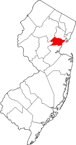 Map of New Jersey highlighting Union County | |
| Boroughs | ||
| Town | ||
| Townships | ||
| Unincorporated communities | ||