Bergen County Line
The Bergen County Line (or Bergen Line) is a commuter rail line and service owned and operated by New Jersey Transit in the U.S. state of New Jersey. The line loops off the Main Line between the Meadowlands and Glen Rock, with trains continuing in either direction along the Main Line. It is colored on NJT system maps in pale blue, and its symbol is a cattail.
| Bergen County Line | |||||||||||||||||||||||||||||||||||||||||||||||||||||||||||||||||||||||||||||||||||||||||||||||||||||||||||||||||||||||||||||||||||||||||||||||||||||||||||||||||||||||||||||||||||||||||||||||||||||||||||||||||||||||||||||||||||||||||||||||||||||||||||||||||||||||||||||||||||||||||||||||||||||||||||||||||||||||||||||||||||||||||||||||||||||||||||||||||||||||||||||||||||||||||||||||||||||||||||||||||||||||||||||||||||||||||
|---|---|---|---|---|---|---|---|---|---|---|---|---|---|---|---|---|---|---|---|---|---|---|---|---|---|---|---|---|---|---|---|---|---|---|---|---|---|---|---|---|---|---|---|---|---|---|---|---|---|---|---|---|---|---|---|---|---|---|---|---|---|---|---|---|---|---|---|---|---|---|---|---|---|---|---|---|---|---|---|---|---|---|---|---|---|---|---|---|---|---|---|---|---|---|---|---|---|---|---|---|---|---|---|---|---|---|---|---|---|---|---|---|---|---|---|---|---|---|---|---|---|---|---|---|---|---|---|---|---|---|---|---|---|---|---|---|---|---|---|---|---|---|---|---|---|---|---|---|---|---|---|---|---|---|---|---|---|---|---|---|---|---|---|---|---|---|---|---|---|---|---|---|---|---|---|---|---|---|---|---|---|---|---|---|---|---|---|---|---|---|---|---|---|---|---|---|---|---|---|---|---|---|---|---|---|---|---|---|---|---|---|---|---|---|---|---|---|---|---|---|---|---|---|---|---|---|---|---|---|---|---|---|---|---|---|---|---|---|---|---|---|---|---|---|---|---|---|---|---|---|---|---|---|---|---|---|---|---|---|---|---|---|---|---|---|---|---|---|---|---|---|---|---|---|---|---|---|---|---|---|---|---|---|---|---|---|---|---|---|---|---|---|---|---|---|---|---|---|---|---|---|---|---|---|---|---|---|---|---|---|---|---|---|---|---|---|---|---|---|---|---|---|---|---|---|---|---|---|---|---|---|---|---|---|---|---|---|---|---|---|---|---|---|---|---|---|---|---|---|---|---|---|---|---|---|---|---|---|---|---|---|---|---|---|---|---|---|---|---|---|---|---|---|---|---|---|---|---|---|---|---|---|---|---|---|---|---|---|---|---|---|---|---|---|---|---|---|---|---|---|---|---|---|---|---|---|---|---|---|---|---|---|---|---|---|---|---|---|---|---|---|---|---|---|---|
 | |||||||||||||||||||||||||||||||||||||||||||||||||||||||||||||||||||||||||||||||||||||||||||||||||||||||||||||||||||||||||||||||||||||||||||||||||||||||||||||||||||||||||||||||||||||||||||||||||||||||||||||||||||||||||||||||||||||||||||||||||||||||||||||||||||||||||||||||||||||||||||||||||||||||||||||||||||||||||||||||||||||||||||||||||||||||||||||||||||||||||||||||||||||||||||||||||||||||||||||||||||||||||||||||||||||||||
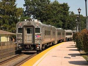 Train #1253 departs Glen Rock–Boro Hall. | |||||||||||||||||||||||||||||||||||||||||||||||||||||||||||||||||||||||||||||||||||||||||||||||||||||||||||||||||||||||||||||||||||||||||||||||||||||||||||||||||||||||||||||||||||||||||||||||||||||||||||||||||||||||||||||||||||||||||||||||||||||||||||||||||||||||||||||||||||||||||||||||||||||||||||||||||||||||||||||||||||||||||||||||||||||||||||||||||||||||||||||||||||||||||||||||||||||||||||||||||||||||||||||||||||||||||
| Overview | |||||||||||||||||||||||||||||||||||||||||||||||||||||||||||||||||||||||||||||||||||||||||||||||||||||||||||||||||||||||||||||||||||||||||||||||||||||||||||||||||||||||||||||||||||||||||||||||||||||||||||||||||||||||||||||||||||||||||||||||||||||||||||||||||||||||||||||||||||||||||||||||||||||||||||||||||||||||||||||||||||||||||||||||||||||||||||||||||||||||||||||||||||||||||||||||||||||||||||||||||||||||||||||||||||||||||
| Type | Commuter rail | ||||||||||||||||||||||||||||||||||||||||||||||||||||||||||||||||||||||||||||||||||||||||||||||||||||||||||||||||||||||||||||||||||||||||||||||||||||||||||||||||||||||||||||||||||||||||||||||||||||||||||||||||||||||||||||||||||||||||||||||||||||||||||||||||||||||||||||||||||||||||||||||||||||||||||||||||||||||||||||||||||||||||||||||||||||||||||||||||||||||||||||||||||||||||||||||||||||||||||||||||||||||||||||||||||||||||
| System | New Jersey Transit Rail Operations Metro-North Railroad | ||||||||||||||||||||||||||||||||||||||||||||||||||||||||||||||||||||||||||||||||||||||||||||||||||||||||||||||||||||||||||||||||||||||||||||||||||||||||||||||||||||||||||||||||||||||||||||||||||||||||||||||||||||||||||||||||||||||||||||||||||||||||||||||||||||||||||||||||||||||||||||||||||||||||||||||||||||||||||||||||||||||||||||||||||||||||||||||||||||||||||||||||||||||||||||||||||||||||||||||||||||||||||||||||||||||||
| Locale | Northern New Jersey | ||||||||||||||||||||||||||||||||||||||||||||||||||||||||||||||||||||||||||||||||||||||||||||||||||||||||||||||||||||||||||||||||||||||||||||||||||||||||||||||||||||||||||||||||||||||||||||||||||||||||||||||||||||||||||||||||||||||||||||||||||||||||||||||||||||||||||||||||||||||||||||||||||||||||||||||||||||||||||||||||||||||||||||||||||||||||||||||||||||||||||||||||||||||||||||||||||||||||||||||||||||||||||||||||||||||||
| Termini | Hoboken Terminal Waldwick | ||||||||||||||||||||||||||||||||||||||||||||||||||||||||||||||||||||||||||||||||||||||||||||||||||||||||||||||||||||||||||||||||||||||||||||||||||||||||||||||||||||||||||||||||||||||||||||||||||||||||||||||||||||||||||||||||||||||||||||||||||||||||||||||||||||||||||||||||||||||||||||||||||||||||||||||||||||||||||||||||||||||||||||||||||||||||||||||||||||||||||||||||||||||||||||||||||||||||||||||||||||||||||||||||||||||||
| Stations | 12 (to Waldwick) 18 (limited service to Suffern) | ||||||||||||||||||||||||||||||||||||||||||||||||||||||||||||||||||||||||||||||||||||||||||||||||||||||||||||||||||||||||||||||||||||||||||||||||||||||||||||||||||||||||||||||||||||||||||||||||||||||||||||||||||||||||||||||||||||||||||||||||||||||||||||||||||||||||||||||||||||||||||||||||||||||||||||||||||||||||||||||||||||||||||||||||||||||||||||||||||||||||||||||||||||||||||||||||||||||||||||||||||||||||||||||||||||||||
| Daily ridership | 4,305[1] | ||||||||||||||||||||||||||||||||||||||||||||||||||||||||||||||||||||||||||||||||||||||||||||||||||||||||||||||||||||||||||||||||||||||||||||||||||||||||||||||||||||||||||||||||||||||||||||||||||||||||||||||||||||||||||||||||||||||||||||||||||||||||||||||||||||||||||||||||||||||||||||||||||||||||||||||||||||||||||||||||||||||||||||||||||||||||||||||||||||||||||||||||||||||||||||||||||||||||||||||||||||||||||||||||||||||||
| Operation | |||||||||||||||||||||||||||||||||||||||||||||||||||||||||||||||||||||||||||||||||||||||||||||||||||||||||||||||||||||||||||||||||||||||||||||||||||||||||||||||||||||||||||||||||||||||||||||||||||||||||||||||||||||||||||||||||||||||||||||||||||||||||||||||||||||||||||||||||||||||||||||||||||||||||||||||||||||||||||||||||||||||||||||||||||||||||||||||||||||||||||||||||||||||||||||||||||||||||||||||||||||||||||||||||||||||||
| Owner | New Jersey Transit (Hoboken Terminal to Suffern) Norfolk Southern Railway (Suffern to Port Jervis, leased to and maintained by Metro-North Railroad) | ||||||||||||||||||||||||||||||||||||||||||||||||||||||||||||||||||||||||||||||||||||||||||||||||||||||||||||||||||||||||||||||||||||||||||||||||||||||||||||||||||||||||||||||||||||||||||||||||||||||||||||||||||||||||||||||||||||||||||||||||||||||||||||||||||||||||||||||||||||||||||||||||||||||||||||||||||||||||||||||||||||||||||||||||||||||||||||||||||||||||||||||||||||||||||||||||||||||||||||||||||||||||||||||||||||||||
| Operator(s) | New Jersey Transit | ||||||||||||||||||||||||||||||||||||||||||||||||||||||||||||||||||||||||||||||||||||||||||||||||||||||||||||||||||||||||||||||||||||||||||||||||||||||||||||||||||||||||||||||||||||||||||||||||||||||||||||||||||||||||||||||||||||||||||||||||||||||||||||||||||||||||||||||||||||||||||||||||||||||||||||||||||||||||||||||||||||||||||||||||||||||||||||||||||||||||||||||||||||||||||||||||||||||||||||||||||||||||||||||||||||||||
| Rolling stock | F40PH-3C/GP40PH-2/ALP-45DP/PL42AC locomotives Comet V/Multilevel coaches | ||||||||||||||||||||||||||||||||||||||||||||||||||||||||||||||||||||||||||||||||||||||||||||||||||||||||||||||||||||||||||||||||||||||||||||||||||||||||||||||||||||||||||||||||||||||||||||||||||||||||||||||||||||||||||||||||||||||||||||||||||||||||||||||||||||||||||||||||||||||||||||||||||||||||||||||||||||||||||||||||||||||||||||||||||||||||||||||||||||||||||||||||||||||||||||||||||||||||||||||||||||||||||||||||||||||||
| Technical | |||||||||||||||||||||||||||||||||||||||||||||||||||||||||||||||||||||||||||||||||||||||||||||||||||||||||||||||||||||||||||||||||||||||||||||||||||||||||||||||||||||||||||||||||||||||||||||||||||||||||||||||||||||||||||||||||||||||||||||||||||||||||||||||||||||||||||||||||||||||||||||||||||||||||||||||||||||||||||||||||||||||||||||||||||||||||||||||||||||||||||||||||||||||||||||||||||||||||||||||||||||||||||||||||||||||||
| Track length | 152.9 km (95.0 mi) | ||||||||||||||||||||||||||||||||||||||||||||||||||||||||||||||||||||||||||||||||||||||||||||||||||||||||||||||||||||||||||||||||||||||||||||||||||||||||||||||||||||||||||||||||||||||||||||||||||||||||||||||||||||||||||||||||||||||||||||||||||||||||||||||||||||||||||||||||||||||||||||||||||||||||||||||||||||||||||||||||||||||||||||||||||||||||||||||||||||||||||||||||||||||||||||||||||||||||||||||||||||||||||||||||||||||||
| Track gauge | 4 ft 8 1⁄2 in (1,435 mm) | ||||||||||||||||||||||||||||||||||||||||||||||||||||||||||||||||||||||||||||||||||||||||||||||||||||||||||||||||||||||||||||||||||||||||||||||||||||||||||||||||||||||||||||||||||||||||||||||||||||||||||||||||||||||||||||||||||||||||||||||||||||||||||||||||||||||||||||||||||||||||||||||||||||||||||||||||||||||||||||||||||||||||||||||||||||||||||||||||||||||||||||||||||||||||||||||||||||||||||||||||||||||||||||||||||||||||
| |||||||||||||||||||||||||||||||||||||||||||||||||||||||||||||||||||||||||||||||||||||||||||||||||||||||||||||||||||||||||||||||||||||||||||||||||||||||||||||||||||||||||||||||||||||||||||||||||||||||||||||||||||||||||||||||||||||||||||||||||||||||||||||||||||||||||||||||||||||||||||||||||||||||||||||||||||||||||||||||||||||||||||||||||||||||||||||||||||||||||||||||||||||||||||||||||||||||||||||||||||||||||||||||||||||||||
Some trains of Metro-North Railroad's Port Jervis Line also operate over the line. The Norfolk Southern Railway provides freight service along the line via trackage rights.
As on the Main Line, trains are powered by diesel locomotives operated push-pull, consisting of Comet or MultiLevel coaches.
History
From a point in Secaucus, just south of the Hackensack River bridge near the former Harmon Cove station, to a point in East Rutherford north of the Rutherford station, the Bergen County Line uses the former Erie Railroad Main Line. This portion was opened in 1833 by the Paterson and Hudson River Railroad[2] and leased by the New York and Erie Rail Road in 1852.[3] The rest of the line, from East Rutherford north to Glen Rock, opened in 1881 as the Bergen County Railroad.
Until the late 1950s, the main function of the Erie's Bergen County Cutoff was as a freight bypass of the at-grade Main Line through Passaic. Commuter service was relatively minor. In 1963 the Lackawanna Boonton Line up to Paterson became the new Erie Main Line. This was due to the abandonment of the Main Line section through downtown Passaic and also due to the fact that Interstate 80 construction used the old Boonton Line right-way in Paterson. The old Main Line up to Rutherford was now exclusively part of the Bergen Line.
Prior to the opening of Secaucus Junction in 2003, Bergen County Line trains used a longer stretch of the old Erie Main Line in Secaucus, extending south to Croxton Yard and a merge with the former Lackawanna Boonton Line. A curving track was built between the HX Draw at Hackensack River and the Main Line north of Secaucus Junction to allow Bergen County Line trains to use Secaucus Junction.
Service
Approaching Secaucus Junction, a westbound train headed for the Bergen County Line will use the more northerly pair of tracks, designated G and H at the transfer. West of the transfer, these tracks diverge from the Main Line over a new right-of-way opened on December 15, 2003, connecting the Main Line with the Bergen County Line. During this stretch, the Hackensack River is to the left, while industrial plants on Meadowlands Parkway are to the right. A former station, Harmon Cove, was located nearby along the old Erie right-of-way and served the high-rise apartments nearby between 1978 and 2003.[5][6]
Soon the train joins the old Erie Main Line right-of-way and crosses the Hackensack over HX Bridge, a two-track bascule draw. For the next two miles, the train crosses the Meadowlands, under the New Jersey Turnpike western spur with the Meadowlands Sports Complex in East Rutherford visible in the distance to the right and a new development beginning to take shape in Rutherford, to the left. Here, the track parallels Berrys Creek and eventually crosses it just before passing below Route 3.
Beyond Route 3, the landscape changes to industrial. Office buildings line the side of the track, some serviced by sidings. The Pascack Valley Line soon splits off to the right at Pascack Junction, and the train then crosses Route 17 and approaches the Rutherford station.
For a half-mile the train passes residences on either side, then swings right, abandoning the old Erie Main Line at 40.836°N 74.1042°W, and passes through industrial areas with several grade crossings. Soon, the tracks form the border of Carlstadt and Wallington. Presently the train passes Wood-Ridge and South Hackensack before reaching the Wesmont station, which opened on May 15, 2016.[7] The train then swings left, crossing the Saddle River, and then right, into Garfield reaching the Garfield station.[8]
The train continues northward through Garfield, passing homes, businesses, and Dahnerts Lake County Park before reaching the Plauderville station at Midland Avenue, the border between Garfield and neighboring Saddle Brook. Shortly after passing beneath U.S. Highway 46 the track becomes the border of Saddle Brook and Elmwood Park, once again crossing Midland Avenue. Interstate 80 passes above the train, which then crosses the Garden State Parkway. The Broadway station in Fair Lawn straddles a border formed by the track and Route 4.
In Fair Lawn, the line is paralleled by Plaza Road, named for Radburn Plaza, the commercial area serving the Radburn development for which the borough's more northerly station is named. The line crosses below Route 208 before reaching Radburn. Beyond the station, the train passes housing to the right and industry to the left, with a spur to a Nabisco plant. Next is the Glen Rock-Boro Hall station which like its Main Line counterpart is on Rock Road. The lines merge a short distance north of this point at Ridgewood Junction. The trains will continue north to either Waldwick or Suffern, and some peak trains will terminate at Ridgewood, which is the first station after the two lines join.[9]
Stations
| State | Zone[10] | Location | Station[10] | Mile (km) | Date opened | Date closed | Line services | Connections[10] | ||
|---|---|---|---|---|---|---|---|---|---|---|
| BC | ML | PJ | ||||||||
| NJ | 1 | Hoboken | Hoboken Terminal |
0.0 (0.0) | 1903 | ● | ● | ● | NJ Transit Rail: Gladstone, Meadowlands, Montclair-Boonton, Morristown, North Jersey Coast, Pascack Valley, and Raritan Valley Lines Hudson-Bergen Light Rail: 8th Street-Hoboken, Hoboken-Tonnelle lines PATH: HOB-WTC, HOB-33, JSQ-33 (via HOB) NJ Transit Bus: 22, 23, 63, 64, 68, 85, 87, 89, 126 New York Waterway to Battery Park City | |
| Secaucus | Secaucus Junction |
3.5 (5.6) | December 15, 2003[11] | ● | ● | ● | NJ Transit Rail (upper level): Gladstone, Montclair-Boonton, Morristown, Northeast Corridor, North Jersey Coast, and Raritan Valley lines NJ Transit Rail (lower level): Meadowlands and Pascack Valley lines NJ Transit Bus: 2, 78, 129, 329, 353 | |||
| 3 | Harmon Cove | June 26, 1978[12] | August 4, 2003[13] | |||||||
| Rutherford | Rutherford |
8.4 (13.5) | June 22, 1832[14] | ● | NJ Transit Bus: 76, 190 | |||||
| 4 | Wood-Ridge | Wesmont | 10.4 (16.7) | May 15, 2016[7][15] | ● | |||||
| Garfield | Garfield | 11.3 (18.2) | ● | NJ Transit Bus: 160, 161, 702, 707, 709, 758 | ||||||
| 5 | Plauderville |
12.7 (20.4) | ● | NJ Transit Bus: 160, 758 | ||||||
| 6 | Fair Lawn | Broadway | 15.3 (24.6) | 1931 | ● | NJ Transit Bus: 144, 166, 770 | ||||
| Radburn | 16.5 (26.6) | 1930[16] | ● | NJ Transit Bus: 145, 171 | ||||||
| 8 | Glen Rock | Glen Rock–Boro Hall | 18.2 (29.3) | ● | NJ Transit Bus: 164, 175, 746 | |||||
| 9 | Ridgewood | Ridgewood |
20.9 (33.6) | October 19, 1848[17][18] | ● | ● | NJ Transit Bus: 163, 164, 175, 722, 746, 752 | |||
| 10 | Ho-Ho-Kus | Ho-Ho-Kus | 22.1 (35.6) | October 19, 1848[17][18] | ● | ● | ||||
| Waldwick | Waldwick | 23.2 (37.3) | 1886[19] | ● | ● | |||||
| 11 | Allendale | Allendale | 24.6 (39.6) | October 19, 1848[17][18] | ● | ● | ||||
| 12 | Ramsey | Ramsey |
26.5 (42.6) | October 19, 1848[20] | ● | ● | ||||
| 13 | Ramsey Route 17 |
27.9 (44.9) | August 22, 2004 | ● | ● | ● | ||||
| 14 | Mahwah | Mahwah | 29.1 (46.8) | October 19, 1848[17][18] | ● | ● | ● | Short Line Bus: 17 | ||
| NY | Suffern | Suffern | 30.5 (49.1) | 1841[21] | ● | ● | ● | Transport of Rockland: 59, 93, Monsey Loop 3, Tappan ZEExpress Short Line Bus: 17M/MD/SF | ||
Bibliography
- Van Valen, James M. (1900). History of Bergen County, New Jersey. New York, New York: New Jersey Publishing and Engraving Company. Retrieved March 2, 2019.CS1 maint: ref=harv (link)
- Wardell, Patricia Webb (1994). Allendale: Background of a Borough. Allendale, New Jersey: Allendale Historical Society. Retrieved August 18, 2017.CS1 maint: ref=harv (link)
- Citizens Semi-Centennial Association (1916). Ridgewood, Bergen County, New Jersey, Past and Present. Ridgewood, New Jersey: Citizens Semi-Centennial Association.CS1 maint: ref=harv (link)
References
- NJT boarding data Berkeley Retrieved July 13, 2008
- "PRR Chronology, 1833" (PDF). (61.1 KiB), June 2004 Edition
- "PRR Chronology, 1852" (PDF). (83.5 KiB), March 2005 Edition
- "NEAR HEAD-ON COLLISION AND DERAILMENT OF TWO NEW JERSEY TRANSIT COMMUTER TRAINS NEAR SECAUCUS, NEW JERSEY FEBRUARY 9, 1996" National Transportation Safety Board
- "Station is dedicated". The Courier-News. Bridgewater, New Jersey. June 20, 1978. p. B5. Retrieved September 3, 2018.
- "Harmon Cove Information". njtransit.com. New Jersey Transit. June 27, 2003. Archived from the original on June 28, 2003. Retrieved May 28, 2018.
- Clark, Susan Joy (May 19, 2016). "Train station opens at Wesmont Development in Wood-Ridge". North Jersey.com. Retrieved September 4, 2018.
- Google Maps. Google https://www.google.com/maps/@40.8598044,-74.1018831,15.34z. Missing or empty
|title=(help) - "Main/Bergen County Line Master File" (PDF). NJTransit.com. NJTransit.
- "Main / Bergen County Lines Timetables - November 19, 2014 edition" (PDF). New York, New York: New Jersey Transit Rail Operations. 2014. Retrieved November 26, 2014.
- Frassinelli, Mike (June 5, 2013). "U.S. Sen. Frank Lautenberg gets one last ride at the Secaucus station that bears his name". The Star-Ledger. Retrieved June 5, 2013.
- New York Division Bulletin. Electric Railroaders' Association. August 2003. Missing or empty
|title=(help) - Sullivan, Al. "Harmon Cove Station will close Bus shuttle service to new station will start in July", The Hudson Reporter, February 1, 2003. Accessed December 28, 2016."
- Van Valen 1900, p. 87.
- Moss, Linda (May 15, 2016). "After 5 years of missed deadlines, Wesmont train station in Wood-Ridge opens". The Record. Retrieved May 15, 2016.
- Radburn New Jersey Transit Railroad Station Survey
- "Common Council". The New York Herald. October 17, 1848. p. 1. Retrieved June 18, 2020 – via Newspapers.com.

- "Ramapo and Paterson and Paterson and Hudson River Railroads". The Evening Post. New York, New York. December 7, 1848. p. 4. Retrieved June 18, 2020 – via Newspapers.com.
- "National Register of Historic Places Inventory -- Nomination Form -- Waldwick Railroad Station". National Park Service. September 21, 1977. p. 8. Retrieved April 12, 2018.
- "Synopsis of Erie History". The Herald-News. Passaic, New Jersey. April 2, 1963. pp. 1, 6. Retrieved March 2, 2019 – via Newspapers.com.
- Green, M.D., Frank Bertangue (1886). "History of Rockland County". New York, New York: A. S. Barnes & Company. Retrieved June 30, 2017.
| Wikimedia Commons has media related to Bergen County Line (New Jersey Transit). |
| Hoboken Division | ||
|---|---|---|
| Newark Division | ||
| Connections | ||
| Current rolling stock | ||
| Bridges and tunnels |
| |
| Stations and yards | ||
| Proposed lines | ||
| Other topics |
| |