Bellingshausen Island
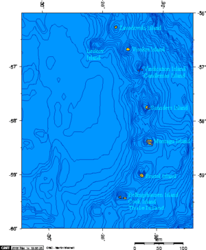
Bellingshausen Island is one of the most southerly of the South Sandwich Islands, close to Thule Island and Cook Island, and forming part of the Southern Thule group. It is named after its discoverer, Baltic German-Russian Antarctic explorer Fabian von Bellingshausen (1778–1852).
 South Sandwich Islands | |
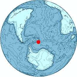 Location of Bellingshausen Island | |
| Geography | |
|---|---|
| Coordinates | 59°25′S 27°3′W |
| Administration | |
United Kingdom | |
The island is a basaltic andesite stratovolcano, and the latest crater, about 152 metres (500 ft) across and 61 metres (200 ft) deep, formed explosively some time between 1968 and 1984. Highest point is Basilisk Peak at 255 metres (837 ft). Its southeast point is called Isaacson Point; first charted by Discovery Investigations personnel on the Discovery II in 1930 and named for Ms. S.M. Isaacson, an assistant to the staff of the Discovery Committee.[1]
See also
- List of Antarctic and sub-Antarctic islands
References
- "Isaacson Point". Geographic Names Information System. United States Geological Survey. Retrieved 2018-08-15.
- "Thule Islands" at Global Volcanism Program
- LeMasurier, W.E.; Thomson, J.W. (eds.) (1990). Volcanoes of the Antarctic Plate and Southern Oceans. American Geophysical Union. p. 512 pp. ISBN 0-87590-172-7.CS1 maint: extra text: authors list (link)
External links
Photos of the island can be found at:
- http://www.photo.antarctica.ac.uk/external/guest/detail/personal/10005836/1/8
- http://cedric-in-antarctica-2009.blogspot.com/2010_02_01_archive.html
Capital: King Edward Point | |
| General | |
| Settlements / Whaling stations | |
| South Georgia islands | |
| South Sandwich islands | |
| Landmarks |
|