Annenkov Island
Annenkov Island is to the west of the main island of South Georgia. The Pickersgill Islands are to its southeast. It is irregularly shaped and 4 miles (6.4 km) long and 650 m (2,130 ft) high, lying 8 miles (13 km) off the south-central coast of South Georgia.
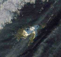 Satellite image of the island | |
 Map showing Annenkov Island | |
| Geography | |
|---|---|
| Coordinates | 54°29′S 37°5′W |
| Archipelago | South Georgia Islands |
| Length | 4 mi (6 km) |
| Highest elevation | 650 m (2,130 ft) |
| Administration | |
United Kingdom | |
| Demographics | |
| Population | Uninhabited |
History
The island was discovered in January 1775 by a British expedition under James Cook, who named it Pickersgills Island for Lieutenant Richard Pickersgill of the expedition ship HMS Resolution. It was rediscovered in 1819 by a Russian expedition under Fabian Gottlieb von Bellingshausen on the Vostok, who, thinking he was the discoverer of the island, named it Annenkov Island for Lieutenant Mikhail Annenkov, officer on the expedition ship. The name Pickersgill has become established for a group of islands 15 miles (24 km) to the southeast — see Pickersgill Islands.
Wildlife
A site of special scientific interest, Annenkov always was and remains one of the few rat-free islands of the South Georgia archipelago, and as Bellinghausen lamented, there is "not a single shrub nor any vegetation" on the island. The main island of South Georgia witnessed a concerted rat eradication campaign that ostensibly was 100% successful.
500 wandering albatross pairs breed here.
Geology
Annenkov island is a rocky island containing a number of ridges and hills. The highest point is Olstad Peak (54°29′S 37°5′W), which rises to 650 m (2,130 ft). Olstad Peak was surveyed by the South Georgia Survey in the period 1951–57, and named by the United Kingdom Antarctic Place-Names Committee for Ola Olstad, Norwegian zoologist, member of the Norwegian expedition under Harald Horntvedt, 1927–28, and chief scientist of the Norwegian expedition under Nils Larsen, 1928–29. The island contains a number of other rocky features, including the McPherson Crags which rise to 460 m (1,510 ft), and a number of ridges and hills such as Albatross Crest, Lawther Knoll, Pettigrew Scarp and Bareback Ridge. Also the rock pillar Spilite Arch on the northeast corner of the island.
The island also contains freshwater lakes, including Intrusion Lake (54°29′S 37°4′W) a 0.2 miles (0.32 km) long lake, located north-northeast of Olstad Peak in central Annenkov Island. It is mapped by the British Antarctic Survey in 1972–73 and so named because its irregular shape is controlled by several intrusions of andesite along its north shore. Additionally, the meltwater Fan Lake is located in the southeast of the island.
The island is bound by First Point in the northwest, and Rustad Bay and South West Point in the southwest. It is surrounded by reefs, including Hauge Reef and Low Reef to the east, and rocky outcroppings, including Horror Rock and Mislaid Rock to the west.
See also
- Composite Antarctic Gazetteer
- History of South Georgia and the South Sandwich Islands
- List of Antarctic islands north of 60° S
- Scientific Committee on Antarctic Research
References
- Stonehouse, B (ed.) Encyclopedia of Antarctica and the Southern Oceans (2002, ISBN 0-471-98665-8)
External links

Capital: King Edward Point | |
| General | |
| Settlements / Whaling stations | |
| South Georgia islands | |
| South Sandwich islands | |
| Landmarks |
|