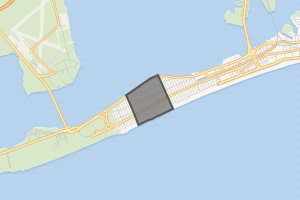
Belle Harbor, Queens
Belle Harbor is a small, affluent residential neighborhood in the New York City borough of Queens, located on the western half of the Rockaway Peninsula, the southernmost area of the borough. Belle Harbor commonly refers to the area from Beach 126th to Beach 141st Streets.[2]
Belle Harbor | |
|---|---|
Neighborhood of Queens | |
Location within New York City | |
| Coordinates: 40.575°N 73.85°W | |
| Country | |
| State | |
| City | |
| County/Borough | |
| Community District | Queens 14[1] |
| Time zone | UTC−5 (EST) |
| • Summer (DST) | UTC−4 (EDT) |
| ZIP Code | 11694 |
| Area codes | 718, 347, 929, and 917 |
The neighborhood is part of Queens Community Board 14.[3] According to the 2010 United States Census, the neighborhood, coupled with nearby Neponsit, had a population just over 5,400.[4] Belle Harbor was the site of the 2001 crash of American Airlines Flight 587, which killed 265 people.
History
The opening of passenger railroad service in 1880 to Rockaway Park from Long Island City and from Flatbush Terminal (now Atlantic Terminal) in downtown Brooklyn, via the Long Island Rail Road's Rockaway Beach Branch, facilitated population growth on the Rockaways Peninsula.
The makings of Belle Harbor began in 1900, when a New York State judge ordered that the land west of Rockaway Park be put up for auction. The area that makes up Belle Harbor and the neighboring community of Neponsit was bought by Edward P. Hatch, who after a couple years, sold it to the West Rockaway Land Company in 1907.[5] The president of the company, Frederick J. Lancaster, who had earlier developed the Edgemere neighborhood, officially gave the community its name.[6] Prior to Lancaster's acquisition of the land, however, a group of men wishing to form a yacht club entered into a grant agreement with the West Rockaway Land Company in 1905. The group, which had named itself the Belle Harbor Yacht Club, bought property from the company for four-thousand dollars. The agreement included two-hundred square feet of land and thirty plots of upland. That same year, the group received corporation status by the State of New York, and by 1908 began participating in its first inter-club ocean races with some of the city's other yacht clubs.[7]
On November 12, 2001, American Airlines Flight 587, bound for Santo Domingo in the Dominican Republic, crashed in the center of Belle Harbor, killing all 260 passengers and crew on board, as well as five others on the ground. Many of the passengers on the plane were from the Dominican community in Washington Heights.[8] After consultation with families in the Belle Harbor and Washington Heights communities, a memorial was erected at Beach 116th Street in Rockaway Park, a major shopping district and transportation hub in the area. Although a temporary memorial was developed at the actual site of the disaster, on Newport Avenue, many still annually gravitate toward the Rockaway Park area for commemoration. In 2001, a resident stated to The Guardian, "It's impossible to understand unless you live here."[9] Father Michael Geraghty, a priest quoted in the same article, said that it was common for people to live in the houses that their parents lived in and that many families lived in the same houses for generations. The neighborhood suffered heavy losses from the September 11, 2001, terrorist attacks."[9]
Belle Harbor was further devastated by Hurricane Sandy on October 29, 2012. Surges from the Jamaica Bay and the Atlantic Ocean flooded the land between these bodies of water. The neighborhood has since been rebuilt.[10]
Demographics
Based on data from the 2010 United States Census, the population of the combined area of Breezy Point/Belle Harbor/Rockaway Park/Broad Channel was 28,018, an increase of 1,307 (4.9%) from the 26,711 counted in 2000. Covering an area of 2,033.88 acres (823.08 ha), the four neighborhoods had a population density of 13.8 inhabitants per acre (8,800/sq mi).[11]
The racial makeup of the neighborhoods was 78.3% (21,946) White, 7.5% (2,095) African American, 0.1% (29) Native American, 2.1% (595) Asian, 0.0% (8) Pacific Islander, 0.2% (66) from other races, and 0.9% (259) from two or more races. Hispanic or Latino of any race were 10.8% (3,020) of the population.[12]
Geography
Belle Harbor is a suburban enclave on the Rockaway Peninsula, on a narrow barrier peninsula sandwiched between the Atlantic Ocean to the south and Jamaica Bay to the north. It is also bordered by the neighborhood of Neponsit to the west and Rockaway Park to the east. Broad, white sandy beaches have drawn residents to the area. Although the beach is ostensibly open to the public, rigorously enforced street parking restrictions in effect on weekends and holidays from May 15 to September 30, combined with limited direct access to the insular area via public transportation, limits access for non-residents.[13]
Community
Belle Harbor is primarily made up of single-family homes with a majority of third and fourth generation Irish Catholic upper class residents. The community also has Italian-American and Jewish American populations, and is home to a large number of New York City police officers and firefighters, both active and retired.[8]
A commercial center is located on Beach 129th Street. A larger shopping area used by some residents of Belle Harbor is located on Beach 116th Street in Rockaway Park.[14]
Transportation
Vehicular access to the area is available via the Marine Parkway–Gil Hodges Memorial Bridge, which provides access to Brooklyn, and the Cross Bay Veterans Memorial Bridge, which connects to Broad Channel and mainland Queens.
The A and S trains of the New York City Subway are available at the Rockaway Park–Beach 116th Street station. Several MTA Bus lines, namely the Q22, Q35, Q53 SBS and QM16, also serve the area.[15]
Education
Belle Harbor residents are zoned for schools in the New York City Department of Education. Residents are zoned to PS/MS 114 Belle Harbor School for grades K-8.[16] Additionally there are some private schools within the area including Saint Francis De Sales, a Catholic School, and three Jewish schools: West End Temple Nursery School, Yeshiva of Belle Harbor, and Yeshiva Mercaz Hatorah of Belle Harbor.
References
- "NYC Planning | Community Profiles". communityprofiles.planning.nyc.gov. New York City Department of City Planning. Retrieved April 7, 2018.
- Lucadamo, Kathleen. "Belle Harbor, Beautiful and Resilient; The Queens beachfront neighborhood has come back from tragedy more than once", The Wall Street Journal, July 17, 2015. Accessed July 21, 2016. "Belle Harbor stretches along Rockaway Beach from 126th to 141st streets and is four blocks wide."
- Queens Community Boards, nyc.gov. Accessed September 3, 2007.
- "Census Nonsense" Archived July 9, 2012, at the Wayback Machine, The Wave. Accessed January 27, 2012.
- Seyfried, Vincent; Asadorian, William (1999). Old Rockaway, New York, in Early Photographs. Mineola, NY: Dover Publications. p. 93. ISBN 0-486-40668-7. Retrieved January 27, 2012.
- "A Queens Timeline" Archived November 9, 2007, at the Wayback Machine, Queens Tribune; accessed December 14, 2006
- "Club History", Belle Harbor Yacht Club Archived April 16, 2012, at the Wayback Machine; accessed January 28, 2012
- "Plane Crash in Queens." Seconds From Disaster. [documentary TV series]
- Younge, Gary. "Flight to the death: Just two months after 9/11, a Queens suburb suffered the second-worst plane crash in US history. Five years on, residents tell Gary Younge, the cause remains worryingly unresolved", The Guardian, November 11, 2006; accessed January 24, 2008. "On flight 587, myriad immigrant stories of hope foundered. On board was Hilda Yolanda Mayol, 26, a waitress who had escaped from the north tower of the World Trade Center and was heading to the Dominican Republic with her mother and children to take her mind off the trauma."
- Hurricane Sandy, theatlantic.com. Accessed October 20, 2015.
- Table PL-P5 NTA: Total Population and Persons Per Acre - New York City Neighborhood Tabulation Areas*, 2010, Population Division - New York City Department of City Planning, February 2012. Accessed July 16, 2016.
- Table PL-P3A NTA: Total Population by Mutually Exclusive Race and Hispanic Origin - New York City Neighborhood Tabulation Areas*, 2010, Population Division - New York City Department of City Planning, March 29, 2011. Accessed July 16, 2016.
- Yarrow, Andrew L. "Out and About on Memorial Day: How to Find That Sand and Surf", The New York Times, May 23, 1986. Accessed October 12, 2007. "Inland, on the blocks between beach and bay, are the well-kept neighborhoods of Neponsit and Belle Harbor. If you're coming by car, daytime street parking is prohibited on weekends and holidays from May 15 to September 30 between Beach 117th and Beach 149th Street..."
- "NYC's Zoning & Land Use Map". nyc.gov. Retrieved November 17, 2018.
- "Queens Bus Map" (PDF). Metropolitan Transportation Authority. December 2017. Retrieved April 24, 2018.
- Home. PS/MS 114 Belle Harbor School. Retrieved on September 16, 2017. Archived February 12, 2019, at the Wayback Machine
External links
| Authority control |
|
|---|