Beit Hanania
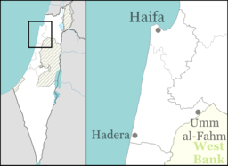
Beit Hanania (Hebrew: בֵּית חֲנַנְיָה, lit. House of Hanania) is a moshav in northern Israel. Located close to the south edge of Mount Carmel close to Zikhron Ya'akov, it falls under the jurisdiction of Hof HaCarmel Regional Council. In 2018 it had a population of 912.[1]
Beit Hanania בֵּית חֲנַנְיָה | |
|---|---|
 | |
 Beit Hanania  Beit Hanania | |
| Coordinates: 32°31′43.67″N 34°55′36.11″E | |
| Country | |
| District | Haifa |
| Council | Hof HaCarmel |
| Affiliation | Moshavim Movement |
| Founded | 1950 |
| Founded by | PICA and Eastern European Jewish immigrants |
| Population (2018)[1] | 912 |
History
The moshav was founded in 1950 by the Palestine Jewish Colonization Association (PICA) and Jewish immigrants from Eastern Europe on land that had belonged to the Palestinian village of Kabara, which was depopulated in the 1948 Palestine war.[2] The new village was named after Hanania Gottlib, a leader of the PICA.[3]
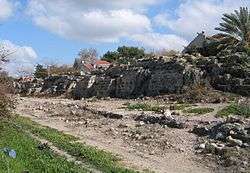
The Israel National Trail runs through the moshav. An aqueduct built in Hadrian's time is located at its entrance, whilst the Taninim River Nature Reserve is located nearby. The Taninim River flows through the park, both of which are named after the alligators (תנינים, Taninim) that, until the beginning of the 20th century, lived in the nearby Cabra swamp.
References
- "Population in the Localities 2018" (XLS). Israel Central Bureau of Statistics. 25 August 2019. Retrieved 26 August 2019.
- Khalidi, Walid (1992). All That Remains: The Palestinian Villages Occupied and Depopulated by Israel in 1948. Washington D.C.: Institute for Palestine Studies. p. 168. ISBN 0-88728-224-5.
- The story of a village in Samaria Davar, 31 March 1961 (in Hebrew)