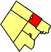
Beckwith, Ontario
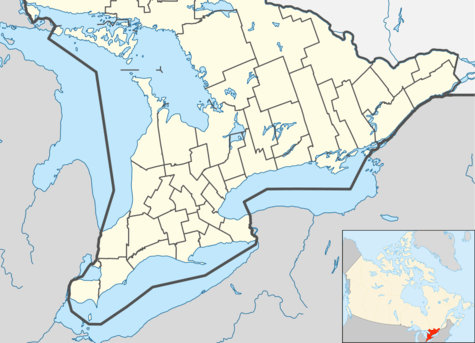
Beckwith is a township in eastern Ontario, Canada. It is located in Lanark County on the Mississippi River. It is located within Canada's National Capital Region.
Beckwith | |
|---|---|
| Township of Beckwith | |
 Beckwith | |
| Coordinates: 45°05′N 76°04′W | |
| Country | Canada |
| Province | Ontario |
| County | Lanark |
| Government | |
| • Type | Township |
| • Reeve | Richard Kidd |
| • Governing Body | Beckwith Township Council |
| • MP | Scott Reid (CPC) |
| • MPP | Randy Hillier (OPC) |
| Area | |
| • Total | 240.47 km2 (92.85 sq mi) |
| Population (2011)[1] | |
| • Total | 7,644 |
| • Density | 31.8/km2 (82/sq mi) |
| Time zone | UTC−05:00 (EST) |
| • Summer (DST) | UTC−04:00 (EDT) |
| Area code(s) | 613 |
| Website | www.twp.beckwith.on.ca |
Communities

The township comprises the communities of Black's Corners, Franktown, Gillies Corners, Prospect, and the western half of Ashton (with the eastern half being within the City of Ottawa), as well as the lakeside communities of Gardiner Shore, Lake Park, Petrie Shore, Rathwell's Shore, Scotch Corners and Tennyson.
Black's Corners, a hamlet south of Carleton Place, is the location for the town hall of Beckwith. This site was chosen in 1857 as a compromise between Franktown and Carleton Place where the township council had met on an alternating basis previously.[2] Currently, there are just a few houses and a store there.
Culture
Franktown promotes itself as the "Lilac Capital of Ontario". It is home to Lilac Lane, which features a beautiful park containing many lilac bushes that have grown there naturally over time, and where a lilac festival is held near the end of May (last Saturday in May).Within the park facility there is also a baseball diamond.
Also located within Franktown are the Calvary Christian Academy, a private school, and the "Franktown General Store", which features a gas bar, general merchandise, a take-out section (opened in 2007) as well as dry-cleaning services.
On the ninth Line Road, east of Blacks Corners, Beckwith Park is being developed. It includes an indoor hockey rink and soccer pitch and outdoor artificial turf for football, soccer and rugby. The park include bush with waking trails and a pond. The extensive grass area, which is not yet fully developed, includes twelve soccer pitches, a baseball and a softball field, a coverall building and open space to hold civic events like Beckwith Heritage Days. The Ottawa Gee-Gees football team played a season there while there new stadium was under construction.
Geography
Beckwith was originally covered in deciduous forest,[3] much of which has been cleared for agriculture. Common trees include sugar maple, beech, oak and ash.[4] Trees like hickory and butternut are less common. Wetter areas have elm, silver maple and white cedar. Hemlock was much more common in the past, but logging for tanbark, used in tanning, has much depleted this species.[5] The enormous Goodwood Swamp is one of the most important natural areas in the township.[6] There are several different access points to see this vast wetland by car and on foot.[7] The Jock River, a popular canoe route, originates here, near Franktown.
The wetlands on the north-western shore of Mississippi Lake are also provincially significant. Within the town of Carleton Place, along the rapids of Mississippi River, there is a large and regionally significant hackberry forest.[8]
The area has two main physiographic types: clay deposits over limestone, and exposed areas of limestone plain. These clay deposits were left behind by the Champlain Sea which flooded the Beckwith area about ten thousand years ago at the end of the last ice age.[9][10] In the extreme northwestern corner there is an outcrop of Canadian Shield. Along the edge of this shield outcrop one can trace the old shoreline of the Champlain Sea.[11]
An Environment and Climate Change Canada weather radar station for Ottawa and eastern Ontario, part of the Canadian weather radar network, is located at Franktown.[12]
Demographics
| Historical populations | ||
|---|---|---|
| Year | Pop. | ±% |
| 2001 | 6,046 | — |
| 2006 | 6,387 | +5.6% |
| 2011 | 6,986 | +9.4% |
| 2016 | 7,644 | +9.4% |
| [13][14][1] | ||
| Canada census – Beckwith, Ontario community profile | |||
|---|---|---|---|
| 2016 | 2011 | 2006 | |
| Population: | 7,644 (+9.4% from 2011) | 6,986 (+9.4% from 2006) | 6,387 (+5.6% from 2001) |
| Land area: | 240.47 km2 (92.85 sq mi) | 240.51 km2 (92.86 sq mi) | 240.12 km2 (92.71 sq mi) |
| Population density: | 31.8/km2 (82/sq mi) | 29.0/km2 (75/sq mi) | 26.6/km2 (69/sq mi) |
| Median age: | 44.4 (M: 43.9, F: 44.9) | 40.5 (M: 40.7, F: 40.2) | |
| Total private dwellings: | 2,860 | 2,817 | 2,649 |
| Median household income: | $102,707 | $77,515 | |
| References: 2016[15] 2011[16] 2006[17] earlier[18] | |||
See also
References
- "Census Profile, 2016 Census: Beckwith, Township". Statistics Canada. Retrieved June 19, 2019.
- Lockwood, Glenn J (1991). Beckwith: Irish and Scottish Identities in a Canadian Community. Carleton Place, Ont: Township of Beckwith. p. 317. ISBN 978-0-9695758-0-1. OCLC 29310814.
- Braun, E. L. 1950. The Deciduous Forest of Eastern North America. New York: Hafner.
- Keddy, P.A. 2008. Earth, Water, Fire. An Ecological Profile of Lanark County. General Store Publishing House, Renfrew, Ontario. (revised from first edition 1999). Map 2.
- Keddy, C.J. 1993. Forest History of Eastern Ontario. A report prepared for the Eastern Ontario Forest Group.
- Keddy, P.A. 2008. Earth, Water, Fire. An Ecological Profile of Lanark County. General Store Publishing House, Refrew, Ontario. Map 14.
- "Goodwood Marsh from highway 15". Retrieved May 24, 2012.
- "Wetlands".
- Chapman,L.J. and D.F. Putnam. 1951. The Physiography of Southern Ontario. University of Toronto Press, Toronto. 284 p. plus map in four sections.
- Anderson, T.W. 1989. Vegetation changes over 12,000 years. Geos 18:39-47.
- Keddy, P.A. 2008. Earth, Water, Fire. An Ecological Profile of Lanark County. General Store Publishing House, Refrew, Ontario. Map 5.
- "Weather Radar - Franktown". Meteorological Service of Canada. Environment Canada. 2009-10-14. Archived from the original on 8 October 2009. Retrieved 2009-10-16.
- Statistics Canada: 1996, 2001, 2006 census
- "Beckwith census profile". 2011 Census of Population. Statistics Canada. Retrieved 2012-02-15.
- "2016 Community Profiles". 2016 Canadian Census. Statistics Canada. February 21, 2017. Retrieved 2017-12-25.
- "2011 Community Profiles". 2011 Canadian Census. Statistics Canada. July 5, 2013. Retrieved 2012-02-15.
- "2006 Community Profiles". 2006 Canadian Census. Statistics Canada. March 30, 2011. Retrieved 2012-02-15.
- "2001 Community Profiles". 2001 Canadian Census. Statistics Canada. February 17, 2012.
External links
Places adjacent to Beckwith, Ontario | ||||||||||
|---|---|---|---|---|---|---|---|---|---|---|
| ||||||||||