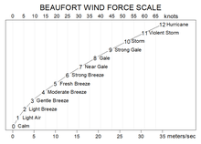
Beaufort scale
The Beaufort scale /ˈboʊfərt/ is an empirical measure that relates wind speed to observed conditions at sea or on land. Its full name is the Beaufort wind force scale.
History
The scale was devised in 1805 by the Irish hydrographer Francis Beaufort (later Rear Admiral Sir Francis Beaufort), a Royal Navy officer, while serving on HMS Woolwich. The scale that carries Beaufort's name had a long and complex evolution from the previous work of others (including Daniel Defoe the century before) to when Beaufort was Hydrographer of the Navy in the 1830s when it was adopted officially and first used during the voyage of HMS Beagle under Captain Robert FitzRoy who was later to set up the first Meteorological Office (Met Office) in Britain giving regular weather forecasts.[1] In the 18th century, naval officers made regular weather observations, but there was no standard scale and so they could be very subjective – one man's "stiff breeze" might be another's "soft breeze". Beaufort succeeded in standardising the scale.

The initial scale of thirteen classes (zero to twelve) did not reference wind speed numbers but related qualitative wind conditions to effects on the sails of a frigate, then the main ship of the Royal Navy, from "just sufficient to give steerage" to "that which no canvas sails could withstand".[2]
The scale was made a standard for ship's log entries on Royal Navy vessels in the late 1830s and was adapted to non-naval use from the 1850s, with scale numbers corresponding to cup anemometer rotations. In 1853, the Beaufort scale was accepted as generally applicable at the First International Meteorological Conference in Brussels.[3] In 1916, to accommodate the growth of steam power, the descriptions were changed to how the sea, not the sails, behaved and extended to land observations. Rotations to scale numbers were standardized only in 1923. George Simpson, CBE (later Sir George Simpson), director of the UK Meteorological Office, was responsible for this and for the addition of the land-based descriptors.[1] The measures were slightly altered some decades later to improve its utility for meteorologists. Nowadays, meteorologists typically express wind speed in kilometers per hour or miles per hour, but Beaufort scale terminology is still used for weather forecasts for shipping[4] and the severe weather warnings given to the public.[5]
Extended scale
The Beaufort scale was extended in 1946 when forces 13 to 17 were added.[3] However, forces 13 to 17 were intended to apply only to special cases, such as tropical cyclones. Nowadays, the extended scale is only used in Taiwan and mainland China, which are often affected by typhoons. Internationally, WMO Manual on Marine Meteorological Services (2012 edition) defined the Beaufort Scale only up to force 12 and there was no recommendation on the use of the extended scale.[6]
Wind speed on the 1946 Beaufort scale is based on the empirical relationship:[7]
- v = 0.836 B3/2 m/s
Where v is the equivalent wind speed at 10 metres above the sea surface and B is Beaufort scale number. For example, B = 9.5 is related to 24.5 m/s which is equal to the lower limit of "10 Beaufort". Using this formula the highest winds in hurricanes would be 23 in the scale.
Today, hurricane-force winds are sometimes described as Beaufort scale 12 through 16, very roughly related to the respective category speeds of the Saffir–Simpson hurricane scale, by which actual hurricanes are measured, where Category 1 is equivalent to Beaufort 12. However, the extended Beaufort numbers above 13 do not match the Saffir–Simpson scale. F1 tornadoes on the Fujita scale and T2 TORRO scale also begin roughly at the end of level 12 of the Beaufort scale, but are independent scales – although the TORRO scale wind values are based on the 3/2 power law relating wind velocity to Beaufort force.[8]
Wave heights in the scale are for conditions in the open ocean, not along the shore.
Modern scale
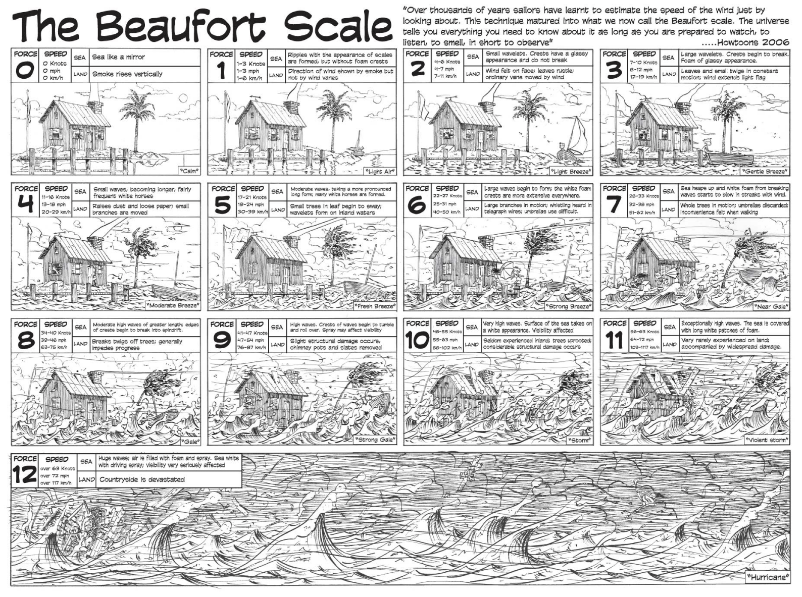
| Beaufort number | Description | Wind speed | Wave height | Sea conditions | Land conditions | Sea conditions (photo) | Associated warning flag |
|---|---|---|---|---|---|---|---|
| 0 | Calm | < 1 knot < 1 mph < 2 km/h < 0.5 m/s |
0 ft (0 m) | Sea like a mirror | Smoke rises vertically. | 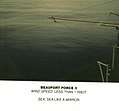 |
|
| 1 | Light air | 1–3 knots | 0–1 ft | Ripples with appearance of scales are formed, without foam crests | Direction shown by smoke drift but not by wind vanes. | 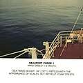 | |
| 1–3 mph | |||||||
| 2–5 km/h | 0–0.3 m | ||||||
| 0.5–1.5 m/s | |||||||
| 2 | Light breeze | 4–6 knots | 1–2 ft | Small wavelets still short but more pronounced; crests have a glassy appearance but do not break | Wind felt on face; leaves rustle; wind vane moved by wind. | 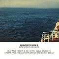 | |
| 4–7 mph | |||||||
| 6–11 km/h | 0.3–0.6 m | ||||||
| 1.6–3.3 m/s | |||||||
| 3 | Gentle breeze | 7–10 knots | 2–4 ft | Large wavelets; crests begin to break; foam of glassy appearance; perhaps scattered white horses | Leaves and small twigs in constant motion; light flags extended. | 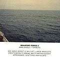 | |
| 8–12 mph | |||||||
| 12–19 km/h | 0.6–1.2 m | ||||||
| 3.4–5.5 m/s | |||||||
| 4 | Moderate breeze | 11–16 knots | 3.5–6 ft | Small waves becoming longer; fairly frequent white horses | Raises dust and loose paper; small branches moved. |  | |
| 13–18 mph | |||||||
| 20–28 km/h | 1–2 m | ||||||
| 5.5–7.9 m/s | |||||||
| 5 | Fresh breeze | 17–21 knots | 6–10 ft | Moderate waves taking a more pronounced long form; many white horses are formed; chance of some spray | Small trees in leaf begin to sway; crested wavelets form on inland waters. |  | |
| 19–24 mph | |||||||
| 29–38 km/h | 2–3 m | ||||||
| 8–10.7 m/s | |||||||
| 6 | Strong breeze | 22–27 knots | 9–13 ft | Large waves begin to form; the white foam crests are more extensive everywhere; probably some spray | Large branches in motion; whistling heard in telegraph wires; umbrellas used with difficulty. | 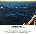 |  |
| 25–31 mph | |||||||
| 39–49 km/h | 3–4 m | ||||||
| 10.8–13.8 m/s | |||||||
| 7 | High wind, moderate gale, near gale | 28–33 knots | 13–19 ft | Sea heaps up and white foam from breaking waves begins to be blown in streaks along the direction of the wind; spindrift begins to be seen | Whole trees in motion; inconvenience felt when walking against the wind. | 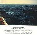 | |
| 32–38 mph | |||||||
| 50–61 km/h | 4–5.5 m | ||||||
| 13.9–17.1 m/s | |||||||
| 8 | Gale, fresh gale | 34–40 knots | 18–25 ft | Moderately high waves of greater length; edges of crests break into spindrift; foam is blown in well-marked streaks along the direction of the wind | Twigs break off trees; generally impedes progress. | 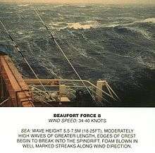 | |
| 39–46 mph | |||||||
| 62–74 km/h | 5.5–7.5 m | ||||||
| 17.2–20.7 m/s | |||||||
| 9 | Strong/severe gale | 41–47 knots | 23–32 ft | High waves; dense streaks of foam along the direction of the wind; sea begins to roll; spray affects visibility | Slight structural damage (chimney pots and slates removed). |  | |
| 47–54 mph | |||||||
| 75–88 km/h | 7–10 m | ||||||
| 20.8–24.4 m/s | |||||||
| 10 | Storm,[12] whole gale | 48–55 knots | 29–41 ft | Very high waves with long overhanging crests; resulting foam in great patches is blown in dense white streaks along the direction of the wind; on the whole the surface of the sea takes on a white appearance; rolling of the sea becomes heavy; visibility affected | Seldom experienced inland; trees uprooted; considerable structural damage. |  |  |
| 55–63 mph | |||||||
| 89–102 km/h | 9–12.5 m | ||||||
| 24.5–28.4 m/s | |||||||
| 11 | Violent storm | 56–63 knots | 37–52 ft | Exceptionally high waves; small- and medium-sized ships might be for a long time lost to view behind the waves; sea is covered with long white patches of foam; everywhere the edges of the wave crests are blown into foam; visibility affected | Very rarely experienced; accompanied by widespread damage. |  | |
| 64–72 mph | |||||||
| 103–117 km/h | 11.5–16 m | ||||||
| 28.5–32.6 m/s | |||||||
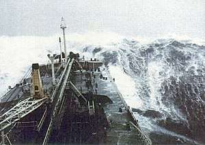
| 12 | Hurricane force [12] | ≥ 64 knots | ≥ 46 ft | The air is filled with foam and spray; sea is completely white with driving spray; visibility very seriously affected | Devastation. |  | |
| ≥ 73 mph | |||||||
| ≥ 118 km/h | ≥ 14 m | ||||||
| ≥ 32.7 m/s |
The Beaufort scale is not an exact nor an objective scale; it was based on visual and subjective observation of a ship and of the sea. The corresponding integral wind speeds were determined later, but the values in different units were never made equivalent.
The scale is used in the Shipping Forecasts broadcast on BBC Radio 4 in the United Kingdom, and in the Sea Area Forecast from Met Éireann, the Irish Meteorological Service. Met Éireann issues a "Small Craft Warning" if winds of Beaufort force 6 (mean wind speed exceeding 22 knots) are expected up to 10 nautical miles offshore. Other warnings are issued by Met Éireann for Irish coastal waters, which are regarded as extending 30 miles out from the coastline, and the Irish Sea or part thereof: "Gale Warnings" are issued if winds of Beaufort force 8 are expected; "Strong Gale Warnings" are issued if winds of Beaufort force 9 or frequent gusts of at least 52 knots are expected.; "Storm Force Warnings" are issued if Beaufort force 10 or frequent gusts of at least 61 knots are expected; "Violent Storm Force Warnings" are issued if Beaufort force 11 or frequent gusts of at least 69 knots are expected; "Hurricane Force Warnings" are issued if winds of greater than 64 knots are expected.
This scale is also widely used in the Netherlands, Germany,[13] Greece, China, Taiwan, Hong Kong, Malta, and Macau, although with some differences between them. Taiwan uses the Beaufort scale with the extension to 17 noted above. China also switched to this extended version without prior notice on the morning of 15 May 2006,[14] and the extended scale was immediately put to use for Typhoon Chanchu. Hong Kong and Macau retain force 12 as the maximum.
In the United States, winds of force 6 or 7 result in the issuance of a small craft advisory, with force 8 or 9 winds bringing about a gale warning, force 10 or 11 a storm warning ("a tropical storm warning" being issued instead of the latter two if the winds relate to a tropical cyclone), and force 12 a hurricane-force wind warning (or hurricane warning if related to a tropical cyclone). A set of red warning flags (daylight) and red warning lights (night time) is displayed at shore establishments which coincide with the various levels of warning.
In Canada, maritime winds forecast to be in the range of 6 to 7 are designated as "strong"; 8 to 9 "gale force"; 10 to 11 "storm force"; 12 "hurricane force". Appropriate wind warnings are issued by Environment Canada's Meteorological Service of Canada: strong wind warning, gale (force wind) warning, storm (force wind) warning and hurricane-force wind warning. These designations were standardized nationally in 2008, whereas "light wind" can refer to 0 to 12 or 0 to 15 knots and "moderate wind" 12 to 19 or 16 to 19 knots, depending on regional custom, definition or practice. Prior to 2008, a "strong wind warning" would have been referred to as a "small craft warning" by Environment Canada, similar to US terminology. (Canada and the USA have the Great Lakes in common.)
See also
- Bowditch's American Practical Navigator
- CLIWOC
- Enhanced Fujita Scale
- Douglas Sea Scale
- Fujita scale
- Saffir–Simpson scale
- Sea state
- Squall
- TORRO scale
- Tropical cyclone
References
- Huler, Scott (2004). Defining the Wind: The Beaufort Scale, and How a 19th-Century Admiral Turned Science into Poetry. Crown. ISBN 1-4000-4884-2.
- "National Meteorological Library and Archive Fact sheet 6 — The Beaufort Scale" (PDF). Met Office. Archived from the original (PDF) on 2 October 2012. Retrieved 13 May 2011.
- Oliver, John E. (2005). Encyclopedia of world climatology. Springer.
- Saucier, Walter Joseph (1955). Principles of Meteorological Analysis. Chicago: The University of Chicago Press. OCLC 1082907714., reprinted in 2003 by Dover Publications.
- McIlveen, Robin (1991). Fundamentals of Weather and Climate. Cheltenham, England: Stanley Thornes. p. 40. ISBN 978-0-7487-4079-6.
- Hay, William W. (2016). Experimenting on a Small Planet: A History of Scientific Discoveries, a Future of Climate Change and Global Warming (second ed.). Cham, Switzerland: Springer Verlag. p. 26. ISBN 978-3-319-27402-7.
- Manual on Marine Meteorological Services: Volume I – Global Aspect (PDF). World Meteorological Organization. 2012. Archived from the original (PDF) on 5 May 2017.
- Beer, Tom (1997). Environmental Oceanography. CRC Press. ISBN 0-8493-8425-7.
- Maiden, Terence. "T-Scale: Origins and Scientific Basis". TORRO. Archived from the original on 5 February 2012. Retrieved 4 January 2012.
- "Beaufort wind force scale". Met Office. Retrieved 27 November 2015.
- "Beaufort Scale". Royal Meteorological Society. Retrieved 27 November 2015.
- "Beaufort Scale". Encyclopædia Britannica. Retrieved 27 November 2015.
- The names "storm" and "hurricane" on the Beaufort scale refer only to wind strength, and do not necessarily mean that other severe weather (for instance, a thunderstorm or tropical cyclone) is present. To avoid confusion, strong wind warnings will often speak of e.g. "hurricane-force winds".
- "Wetterlexikon - Beaufort-Skala" (in German). Deutscher Wetterdienst. Archived from the original on 12 December 2013. Retrieved 2014-02-14.
- "昨日实行新标准"珍珠"属强台风_新闻中心_新浪网". news.sina.com.cn.
External links
| Wikimedia Commons has media related to Beaufort Scale. |
| Wikisource has the text of the 1911 Encyclopædia Britannica article Beaufort Scale. |
- National Meteorological Library and Archive fact sheet on the history of the Beaufort Scale, including various scales and photographic depictions of the sea state.
- Film of Wind Scale
- Historical Wind Speed Equivalents Of The Beaufort Scale
- Howtoons Poster showing effects on land/sea effects at each step.
- Beaufort scale, cites the original definition formula
- Ireland's Beaufort was Windscale Inventor—by Dr John de Courcy Ireland
- The Beaufort Scale and Weather Diaries of Rear Admiral Sir Francis Beaufort—The history of the Beaufort Scale
- Radio interview with Scott Huler
- Beaufort wind force scale. Met Office
- US Economic Costs of High Winds at NOAA Economics
| Authority control |
|
|---|