Bay of Bangkok
The Bay of Bangkok (Thai: อ่าวกรุงเทพ, RTGS: Ao Krung Thep, Thai pronunciation: [ʔàːw kruŋ tʰêːp]), also known as the Bight of Bangkok, is the northernmost part of the Gulf of Thailand, roughly extending from Hua Hin District to the west and Sattahip District to the east. Three of the major rivers of central Thailand empty into the bay - the Chao Phraya and its distributary Tha Chin, the Mae Klong and the Bang Pakong River.
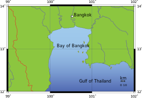
Bay of Bangkok map
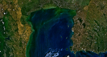
NASA picture of the Bay of Bangkok
There are some islands off the eastern shores of the bay, like Ko Sichang, Ko Lan and Ko Phai.[1]
Environment
The water quality of the Bay of Bangkok is rated as "very poor" by the Pollution Control Department.[2]:54
References
- Hydrographic Service of the Royal Thai Navy, Chart 142
- Thailand State of Pollution Report 2015 (PDF). Bangkok: Pollution Control Department, Ministry of Natural Resources and Environment (Thailand). 2016. ISBN 978-616-316-327-1. Retrieved 5 September 2017.
This article is issued from Wikipedia. The text is licensed under Creative Commons - Attribution - Sharealike. Additional terms may apply for the media files.