Barahona Province
Barahona (Spanish pronunciation: [baɾaˈona]) is a province of the Dominican Republic. The Barahona Coast is located on the southwestern part of the Dominican Republic approximately three hours drive from Santo Domingo the capital of the Dominican Republic. In 2019, volunteers from Amigos de las Americas visited to facilitate projects within the various municipalities of Barahona.[2]
Barahona | |
|---|---|
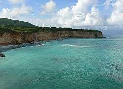 Sea Cliff on Caribbean coast near El Quemaíto, Barahona Province, Dominican Republic. | |
 Seal | |
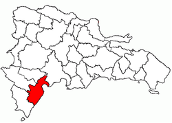 Location of the Barahona Province | |
| Coordinates: 18°12′0″N 71°06′0″W | |
| Country | Dominican Republic |
| Province since | 1881 |
| Capital | Santa Cruz de Barahona |
| Area | |
| • Total | 1,739.38 km2 (671.58 sq mi) |
| Population (2014)[1] | |
| • Total | 232,818 |
| • Density | 130/km2 (350/sq mi) |
| Time zone | UTC-4 (EST) |
| Area code(s) | 1-809 1-829 1-849 |
| ISO 3166 code | DO-04 |
Municipalities and municipal districts
The province as of June 20, 2006 is divided into the following municipalities (municipios) and municipal districts (distrito municipal - D.M.) within them:[3]
- Cabral
- El Peñón
- Enriquillo
- Arroyo Dulce (D.M.)
- Fundación
- Pescadería (D.M.)
- Jaquimeyes
- Palo Alto (D.M.)
- La Ciénaga
- Bahoruco (D.M.)
- Las Salinas
- Paraíso
- Los Patos (D.M.)
- Polo
- Santa Cruz de Barahona
- El Cachón (D.M.)
- La Guázara (D.M.)
- Vicente Noble
- Canoa (D.M.)
- Fondo Negro (D.M.)
- Quita Coraza (D.M.)
The following is a sortable table of the municipalities and municipal districts with population figures as of the 2014 estimate. Urban population are those living in the seats (cabeceras literally heads) of municipalities or of municipal districts. Rural population are those living in the districts (Secciones literally sections) and neighborhoods (Parajes literally places) outside them. The population figures are from the 2014 population estimate.[4]
| Name | Total population | Urban population | Rural population |
|---|---|---|---|
| Cabral | 12,623 | 8,371 | 4,252 |
| El Peñón | 4,022 | 2,014 | 2,008 |
| Enriquillo | 9,923 | 5,911 | 4,012 |
| Fundación | 6,212 | 1,152 | 5,060 |
| Jaquimeyes | 4,422 | 1,898 | 2,524 |
| La Ciénaga | 8,023 | 1,604 | 6,419 |
| Paraíso | 16,223 | 9,014 | 7,209 |
| Polo | 7,895 | 4,244 | 3,651 |
| Salinas | 4,992 | 3,940 | 1,052 |
| Santa Cruz de Barahona | 138,470 | 123,616 | 14,854 |
| Vicente Noble | 20,013 | 9,854 | 10,159 |
| Barahona province | 232,818 | 171,618 | 61,200 |
For comparison with the municipalities and municipal districts of other provinces see the list of municipalities and municipal districts of the Dominican Republic.
References
- Consejo Nacional de Población y Familia. "Estamaciones y Proyecciones de la Población Dominicana por Regiones, Provincias, Municipios y Distritos Municipales, 2014" (PDF) (in Spanish). Retrieved 2014-02-02.
- "Getting to know Barahona".
- Oficina Nacional de Estadistica, Departamento de Cartografia, Division de Limites y Linderos. "Listado de Codigos de Provincias, Municipio y Distritos Municipales, Actualizada a Junio 20 del 2006" (in Spanish). Archived from the original on August 3, 2007. Retrieved 2007-01-24.CS1 maint: uses authors parameter (link)
- Consejo Nacional de Población y Familia. "Estamaciones y Proyecciones de la Población Dominicana por Regiones, Provincias, Municipios y Distritos Municipales, 2014" (PDF) (in Spanish). Retrieved 2014-02-02.
External links
- (in Spanish) Information on the Barahona province and the Southwest region of the Dominican Republic
- (in Spanish) Oficina Nacional de Estadística, Statistics Portal of the Dominican Republic
- (in Spanish) Oficina Nacional de Estadística, Maps with administrative division of the provinces of the Dominican Republic, downloadable in PDF format