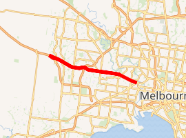
Ballarat Road, Melbourne
Ballarat Road (in its westernmost part the Western Highway) is a major urban arterial road in the western suburbs of Melbourne, Victoria, Australia.
Ballarat Road | |
|---|---|
| |
 West end East end | |
| Coordinates |
|
| General information | |
| Type | Road |
| Length | 16 km (9.9 mi) |
| Route number(s) | |
| Major junctions | |
| West end | |
| East end | |
| Location(s) | |
| Major suburbs | Caroline Springs, Deer Park, Albion, Sunshine, Braybrook |
History
Previously known as the Western Highway, the road is signed as State Route 8. The Deer Park Bypass (completed 2009) carries the National Highway M8 designation while the Ballarat Road from Caroline Springs through Deer Park has the blue Route 8 shield. Route 8 continues on Ballarat Road across the Western Ring Road (opened 1996) to the inner suburb of Footscray. The freeway was originally designated in the 1969 Melbourne Transportation Plan as part of the F12 Freeway corridor.
Geography
Ballarat Road starts at the Footscray junction of Princes Highway (Geelong Road) in Footscray and continues west through Maidstone, Braybrook, Sunshine, Albion, Cairnlea, Deer Park, Burnside, and Caroline Springs. The major junctions along the route include the Western Ring Road and the Deer Park Bypass.
Transport
Tram route 82 runs along the Footscray section of Ballarat Road, between Gordon & Droop Streets. The Melton railway line from Southern Cross runs parallel to Ballarat Road from Sunshine about 1 km to the south, with stations at Albion, and Deer Park. Several bus routes run along Ballarat Road at various points (routes 215, 216, 220, 223, 256, 400, 406, 408, 410 and 456) with 456 continuing on the Western Freeway to Melton.
With three lanes running in each direction, between Deer Park and the Western Ring Road, this was one of the worst bottlenecks in western Melbourne with traffic reaching 70,000 vehicles per day, with 10 per cent of this consisting of heavy vehicles. This caused delays, in part due to seven traffic signals between the Western Ring Road and the start of the Western Freeway. With the completion of the Deer Park Bypass traffic volumes were predicted to decrease to local traffic standard since its opening on 5 April 2009.
Beyond that, to central Melbourne, Ballarat Road has a single carriageway from Braybrook and is a two lane arterial road, including one small stretch which shares the road with trams.
Major intersections and suburbs
| Location[1] | km[1] | mi | Destinations | Notes | |
|---|---|---|---|---|---|
| Ravenhall | 0.0 | 0.0 | |||
| Ravenhall, Caroline Springs | 0.9 | 0.56 | Christies Road / Caroline Springs Boulevard – Caroline Springs, Melbourne via M8 | ||
| Ravenhall, Burnside | 2.4 | 1.5 | Westwood Drive – Hoppers Crossing, Burnside | ||
| Deer Park | 4.4 | 2.7 | Station Road – Laverton, Taylors Lakes | ||
| Deer Park, Cairnlea | 5.4 | 3.4 | Kororoit Creek | ||
| Deer Park, Ardeer, Cairnlea | 6.2 | 3.9 | |||
| Albion | 8.9 | 5.5 | Bendigo railway line | ||
| Sunshine | 9.3 | 5.8 | St Albans Road – St Albans; | ||
| Sunshine, Sunshine North, Braybrook | 11.0 | 6.8 | Duke Street – Braybrook, Sunshine North | ||
| Braybrook | 12.6 | 7.8 | Ashley Street – Tottenham, Yarraville | ||
| Maidstone | 12.9 | 8.0 | |||
| Maidstone, Footscray | 14.3 | 8.9 | Summerhill Road / Rosamond Road – West Footscray, Maribyrnong | ||
| Footscray | 15.0 | 9.3 | |||
| 15.3 | 9.5 | Droop Street – Footscray | |||
| 15.4 | 9.6 | Farnsworth Avenue – Ascot Vale | |||
| 16.0 | 9.9 | continues as | |||
1.000 mi = 1.609 km; 1.000 km = 0.621 mi
| |||||
See also
References
- Google (7 January 2017). "Ballarat Road, Melbourne" (Map). Google Maps. Google. Retrieved 7 January 2017.
Road infrastructure in Melbourne | |
|---|---|
| Freeways | |
| Highways |
|
| Bypasses | |
| Bridges and tunnels |
|
| Proposals | |
| |