Bakhtegan Lake
Lake Bakhtegan (Persian: دریاچۀ بختگان) was a salt lake in Fars Province, southern Iran, about 160 km (99 mi) east of Shiraz and 15 km (9.3 mi) west of the town of Neyriz.
| Lake Bakhtegan | |
|---|---|
 | |
| Coordinates | 29.3654°N 53.8385°E |
| Type | Salt lake |
| Primary inflows | Kor River |
| Basin countries | Iran |
| Surface area | 3,500 km2 (1,400 sq mi) |
| Islands | Menak Island |
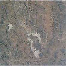
Bakhtegan, with a surface area of 3,500 square kilometres (1,400 sq mi), was Iran's second-largest lake. It was fed by the Kor River.[1] Several dams on the Kor River had significantly reduced waterflow into the lake, increasing its salinity and endangering the lake's populations of flamingos and other migratory birds.[1] Lake Bakhtegan is now completely dry due to the dams built on the Kor River by the government.
Description
Lake Bakhtegan, Iran’s second largest lake, is fed mostly by the Kur River, while Lake Tashk is fed by overflow from the marshes at its west end and by a large permanent spring in the northwest.
Although normally separated by narrow strips of land, during years of heavy rainfall they may join to form a single lake. Likewise, after years of low rainfall, such as in 1934 and 1971, the lakes may dry out completely except in the area near the springs.
Supporting more than 20 000 waterfowl during the migration seasons and in winter, the lakes are extremely important for breeding of a wide variety of species and helping to maintain the genetic and ecological diversity of the region.
The two lakes, their delta and spring-fed marshes are designated as Wetlands of International Importance by the Ramsar Convention on Wetlands. The Ramsar Convention on Wetlands is an inter-governmental treaty established in 1971, establishing a framework for the stewardship and preservation of wetlands.