Kabir Kouh Protected Area
Kabir Kouh Protected Area is a nature conservatory in Darreh Shahr and Badreh counties, Ilam Province, Iran. Established in October 2001, it covers an area of 179 km2 (69 sq mi) on the northern side of Kabir Kouh range between the elevations of 950 to 2790m.[2]
| Kabir Kouh Protected Area | |
|---|---|
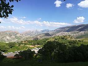 Kabir Kouh in spring | |
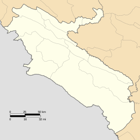 Location within Ilam Province | |
| Location | Darreh Shahr and Badreh |
| Nearest city | Darreh Shahr and Badreh |
| Coordinates | 33.21°N 47.21°E |
| Area | 179 km2 (69 sq mi) |
| Established | October 17, 2001[1] |
| Governing body | FRW of Ilam Province |
The area is mostly mountainous with steep slopes, a rocky base and shallow soil. Water stream are prevalent in the area.
Geology
Kabir Kou Protected Area is located in the Zagros Mountains. Its lithology is generally composed of sedimentary rocks and this has played an important role in the emergence and evolution of vegetation and the biodiversity of the region and the formation of wildlife habitats. The geological units and existing deposits, due to lateral pressures on both sides of the northeastern and southwest, have become folded into a set of anti-knives. As a result, there have been numerous dangers and diversions that actually form the mountains and valleys of the area.[2]
Climate
The average long-term annual precipitation is 350.4 mm (13.80 in), 99 percent of which comes in the period of December to May. Therefore, the driest season is summer.
For every 1,000 m (3,300 ft), precipitation increases by 162 mm (6.4 in) and the average temperature decreases by 5.8 °C. Based on meteorological data, there are periods of dry and wet in about every five years.
The average annual maximum temperature varies between 15 and 30 °C at different altitudes and the average annual minimum temperature between −2° to 16 °C. The maximum and minimum absolute temperatures ever recorded are 47 and −15 °C. The average maximum and minimum temperatures are 21.7 and 11.6 °C.
The average annual relative humidity of the region is 47.1 percent. August has the lowest and February the highest relative humidity.[2]
Flora
Most of the area is covered by forests and pastures. The vegetation in area varies, the farther it is from settlements, the richer the vegetation gets. Due to excessive exploitation, the soil has been subject to erosion in many areas and many gullies have been forming. The deforestation is also prevalent in the region as people use the tree forage for their livestock. Nevertheless, ever since the establishment of the protected area, the degradation has been slowing down.[2]
The Quercus persica is the prevalent tree in the higher altitudes. There is also a very small patch of woods with a rare species of Pterocarya fraxinifolia near Badreh.
The most important herbaceous species are:
Fauna
Due to its special rocky landscape, steep slopes and high cliffs, the area is home to a diverse range of inhabitants. A full wildlife descriptions of the region requires further studies. Nonetheless, the most important species are Bear, Persian leopard, Hare, Wildcat, Caracal, Wolf, Jackal, Fox, Hyena, Weasel, Caucasian squirrel, Southern white-breasted hedgehog, Long-eared hedgehog, Grey dwarf hamster and Wild goat.
References
- "منطقه حفاظت شده کبیرکوه". www.doe.ir. Retrieved 13 July 2019.
- "منطقه حفاظت شده کبیر کوه ، ایلام". کویرها و بیابانهای ایران (in Persian). 2011-12-10. Retrieved 2019-07-13.