Ayn al-Bayda, Latakia
Ayn al-Bayda (Arabic: عين البيضة) is a town in northwestern Syria, administratively part of the Latakia Governorate, located north of Latakia. Nearby localities include Al-Shamiyah and Burj Islam to the west, al-Bahluliyah and Mashqita to the east and Mushayrafet al-Samouk to the southwest. According to the Syria Central Bureau of Statistics, Ayn al-Bayda had a population of 1,629 in the 2004 census.[1] Its inhabitants are predominantly Alawites.[2]
Ayn al-Bayda عين البيضة | |
|---|---|
Town | |
 | |
 Ayn al-Bayda | |
| Coordinates: 35°39′14″N 35°52′23″E | |
| Country | |
| Governorate | Latakia Governorate |
| District | Latakia District |
| Nahiyah | Ayn al-Bayda |
| Population (2004 census)[1] | |
| • Total | 1,629 |
| Time zone | UTC+2 (EET) |
| • Summer (DST) | UTC+3 (EEST) |
| Climate | Csa |
Climate
The climate is mild, and generally warm and temperate. There is more rainfall in the winter than in the summer. The climate is considered to be Csa according to the Köppen-Geiger climate classification. The average annual temperature is 18.5 °C. In a year, the average rainfall is 1004 mm. [3]
| Climate data for Slinfah | |||||||||||||
|---|---|---|---|---|---|---|---|---|---|---|---|---|---|
| Month | Jan | Feb | Mar | Apr | May | Jun | Jul | Aug | Sep | Oct | Nov | Dec | Year |
| Average high °C (°F) | 9.9 (49.8) |
10.8 (51.4) |
13.3 (55.9) |
16.6 (61.9) |
20.2 (68.4) |
23.9 (75.0) |
26.3 (79.3) |
26.9 (80.4) |
24.9 (76.8) |
21.1 (70.0) |
16.2 (61.2) |
11.4 (52.5) |
18.5 (65.2) |
| Average low °C (°F) | 6.3 (43.3) |
6.8 (44.2) |
9 (48) |
11.7 (53.1) |
15.1 (59.2) |
19.3 (66.7) |
22.3 (72.1) |
22.5 (72.5) |
19.6 (67.3) |
15.6 (60.1) |
11.2 (52.2) |
7.7 (45.9) |
13.9 (57.1) |
| Average precipitation mm (inches) | 179 (7.0) |
160 (6.3) |
121 (4.8) |
59 (2.3) |
36 (1.4) |
9 (0.4) |
3 (0.1) |
5 (0.2) |
26 (1.0) |
66 (2.6) |
101 (4.0) |
239 (9.4) |
1,004 (39.5) |
| Source: Climate-data.org, retrieved 12 August 2017 | |||||||||||||
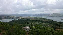
 Panoramic view of Ayn al-Bayda
References
- General Census of Population and Housing 2004. Syria Central Bureau of Statistics (CBS). Latakia Governorate. (in Arabic)
- Balanche, Fabrice (2006). La région alaouite et le pouvoir syrien (PDF) (in French). Karthala Editions. ISBN 2845868189.
- "Climate 'Ayn Al-Bayda': Temperature, Climate graph, Climate table for 'Ayn al-Bayda' - Climate-Data.org".
Capital: Latakia | |||||
| |||||
| |||||
This article is issued from Wikipedia. The text is licensed under Creative Commons - Attribution - Sharealike. Additional terms may apply for the media files.