Audubon Park, Minneapolis
The Audubon Park neighborhood is located in the Northeast community in Minneapolis. Audubon Park is one of ten neighborhoods in Ward 1 of Minneapolis, which since 2009 has been represented on the Minneapolis City Council by Councilmember Kevin Reich. The neighborhood is bounded by Saint Anthony Parkway to the north, Stinson Boulevard to the east, Lowry Avenue to the south, and Central Avenue to the west. Stinson Boulevard and St. Anthony Parkway are both part of the Grand Rounds National Scenic Byway. Stinson Boulevard is also the city's border with St. Anthony.
Audubon Park | |
|---|---|
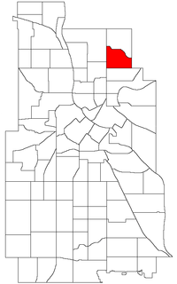 Location of Audubon Park within the U.S. city of Minneapolis | |
| Country | United States |
| State | Minnesota |
| County | Hennepin |
| City | Minneapolis |
| Community | Northeast |
| Area | |
| • Total | 0.665 sq mi (1.72 km2) |
| Population (2010)[2] | |
| • Total | 4,962 |
| • Density | 7,500/sq mi (2,900/km2) |
| Time zone | UTC-6 (CST) |
| • Summer (DST) | UTC-5 (CDT) |
| ZIP code | 55418 |
| Area code(s) | 612 |
| Historical population | |||
|---|---|---|---|
| Census | Pop. | %± | |
| 1980 | 5,924 | — | |
| 1990 | 5,667 | −4.3% | |
| 2000 | 5,256 | −7.3% | |
| 2010 | 4,962 | −5.6% | |
Audubon Park is also the name of the only city park located entirely within the boundaries of the Audubon Park neighborhood. The park and neighborhood are named in honor of John James Audubon, a great American naturalist and ornithologist. A majority of the houses in this relatively hilly neighborhood were built in the 1940s.
References
- "Audubon Park neighborhood in Minneapolis, Minnesota (MN), 55418 detailed profile". City-Data. 2011. Retrieved 2013-11-16.
- "Minneapolis Neighborhood Profile: Audubon Park" (PDF). Minnesota Compass. October 2011. Retrieved 2013-11-15.
- Audubon Park, Minneapolis, MN. Google Earth. Retrieved 2011-03-09.
External links
Places adjacent to Audubon Park, Minneapolis | ||||||||||
|---|---|---|---|---|---|---|---|---|---|---|
| ||||||||||