Au, Vorarlberg
Au is a town in the Bregenz Forest in the westernmost Austrian state of Vorarlberg.
Au | |
|---|---|
 | |
 Coat of arms | |
 Location in the district | |
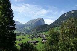
 Au Location within Austria | |
| Coordinates: 47°19′00″N 09°59′00″E | |
| Country | Austria |
| State | Vorarlberg |
| District | Bregenz |
| Government | |
| • Mayor | Ing. Andreas Simma (Auer Liste) |
| Area | |
| • Total | 44.91 km2 (17.34 sq mi) |
| Elevation | 800 m (2,600 ft) |
| Population (2018-01-01)[2] | |
| • Total | 1,736 |
| • Density | 39/km2 (100/sq mi) |
| Time zone | UTC+1 (CET) |
| • Summer (DST) | UTC+2 (CEST) |
| Postal code | 6883 |
| Area code | 05515 |
| Vehicle registration | B |
| Website | www.au-schoppernau.at |
Geography
The town belongs to the Bregenz Forest, part of the district of Bregenz, and lies in the Hintere Bregenzerwald.
Forty percent of its 45 km² area is covered with forest, 34.4% of the area is used as alpine pasture (Almwirtschaft) and for other forms of alpine agriculture.
The town itself is unlike most others in the area, as it has no real center. Au is an example of a "scattered village" (German: Streudorf). It consists of several districts: Am Stein, Argenau, Argenstein, Argenzipfel, Jaghausen, Kreuzgasse, Lebernau, Lugen, Lisse, Rehmen, Schrecken, and Wieden.
The town hall is located in Argenau, but the parish church is located in Jaghausen. The district of Rehmen also has its own church.
The river Bregenzer Ach, the largest river in the region, flows through Au and divides it into two parts: The one part is called Schattseite (meaning “shady side”), and consists of the districts of Argenau, Argenzipfel and Wieden; the other part is called Sonnseite (meaning “sunny side”) and consists (mainly) of Rehmen and Schrecken. Alongside the river runs the L200 road, which is the main route through the Bregenz Forest.
History
The Vorarlberger Münsterschema, a type of Baroque cathedral, was developed by the Beer and Thumb families. Examples of such cathedrals can be found along Lake Constance and in other parts of southern Germany.
Michael Beer also founded the Auer Zunft, one of the oldest craftsmen’s guilds in Austria. It still exists today.
From 1805 to 1814 Au belonged to the Kingdom of Bavaria, but was then returned to Austria. Au has belonged to the province of Vorarlberg since the latter’s foundation in 1861.
After World War II Au was included within the French Occupation Zone of Austria. The occupation lasted from 1945 until the Austrian State Treaty was signed in 1955. The occupation force also included many Moroccan soldiers serving in the French army.
Population
| Historical population | ||
|---|---|---|
| Year | Pop. | ±% |
| 1869 | 1,039 | — |
| 1880 | 1,060 | +2.0% |
| 1890 | 1,067 | +0.7% |
| 1900 | 1,116 | +4.6% |
| 1910 | 1,210 | +8.4% |
| 1923 | 1,080 | −10.7% |
| 1934 | 1,269 | +17.5% |
| 1939 | 1,263 | −0.5% |
| 1951 | 1,414 | +12.0% |
| 1961 | 1,440 | +1.8% |
| 1971 | 1,476 | +2.5% |
| 1981 | 1,466 | −0.7% |
| 1991 | 1,572 | +7.2% |
| 2001 | 1,643 | +4.5% |
| 2011 | 1,692 | +3.0% |
| 2017 | 1,728 | +2.1% |
Politics
The town council of Au, called Gemeinderat, consists of 18 members, all of them members of the Auer Liste. The current mayor is Pius Natter.
Economics and infrastructure
A main economic factor in Au is tourism. Many private households rent out rooms or flats. There are several hotels, many of them providing special venues or events, e.g. wellness, sports, and motorbiking. Agriculture was formerly the main income source for the village, until the rise of tourism.
Transportation
Au is situated on the L200, the Bregenzerwald Bundesstrasse. Here it connects to the L193, the Faschina Bundesstrasse, which is the main route to the skiing resort of Damüls. Public transportion consists of the Postbus Line 40, running from Dornbirn to Schoppernau. In winter there is also a free bus service running through the town for skiers and locals.
Education
There is a kindergarten, a Volksschule (primary school), and a Hauptschule (lower secondary school), all located in a building in the district Schrecken. The secondary school also serves the towns of Schnepfau, Schoppernau, Damüls and Schröcken.
Personalities
- Kaspar Moosbrugger (Vorarlberg School; * May 16, 1656 in Au; † August 26, 1723 in Einsiedeln)
- Franz Beer (master builder and co-founder of Vorarlberg School; * April 1, 1660 in Au (Vorarlberg); † January 21, 1726 in Bezau
See also
References
- "Dauersiedlungsraum der Gemeinden Politischen Bezirke und Bundesländer - Gebietsstand 1.1.2018". Statistics Austria. Retrieved 10 March 2019.
- "Einwohnerzahl 1.1.2018 nach Gemeinden mit Status, Gebietsstand 1.1.2018". Statistics Austria. Retrieved 9 March 2019.
External links
| Authority control |
|
|---|