Bludenz
Bludenz (Alemannic: Bludaz) is a town in the westernmost Austrian state of Vorarlberg. It is the administrative seat of the Bludenz District, which encompasses about half of the Vorarlberg's territory.
Bludenz Bludaz | |
|---|---|
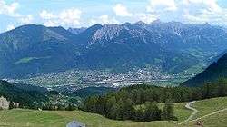 View from southwest | |
 Coat of arms | |
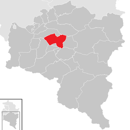 Location in the district | |
 Bludenz Location within Austria | |
| Coordinates: 47°08′00″N 09°49′00″E | |
| Country | Austria |
| State | Vorarlberg |
| District | Bludenz |
| Government | |
| • Mayor | Josef Katzenmayer (ÖVP) |
| Area | |
| • Total | 29.92 km2 (11.55 sq mi) |
| Elevation | 588 m (1,929 ft) |
| Population (2018-01-01)[2] | |
| • Total | 14,539 |
| • Density | 490/km2 (1,300/sq mi) |
| Time zone | UTC+1 (CET) |
| • Summer (DST) | UTC+2 (CEST) |
| Postal code | 6700 |
| Area code | 05552 |
| Vehicle registration | BZ |
| Website | Official website |
Geography
The town is located on the Ill River, a direct tributary of the Rhine. It is surrounded by the ranges of the Bregenz Forest Mountains in the north, and by the Rätikon and Silvretta ranges in the south. Bludenz lies at the meeting point of five valleys: Walgau and Montafon (Ill), Brandnertal, Klostertal up to Arlberg Pass, and Großes Walsertal.
Bludenz is a popular starting point for hiking and mountain-biking in spring, summer, and autumn. It is located not far from many skiing resorts (e.g., Brand[3] and Lech[4]).
Major companies are Mondelēz International (Milka chocolate) and Fohrenburger beer.[5]

History
Archaeological finds indicate that settlement in the area of Bludenz began in the Bronze Age,[6] and continued throughout the La Tène era. In 600 BC there was a Roman military training ground.
Bludenz itself was first mentioned in the year 830 CE in an urbarium of the Raetian estates within the Carolingian Empire. The town was established by the comital Werdenberg dynasty; town privileges were granted in 1274. A stay by the Habsburg Duke Frederick IV of Austria, who had just received an imperial ban at the Council of Constance, is documented from 30 March 1416. Four years later, Bludenz passed into the Further Austrian possessions of the Habsburg dynasty.
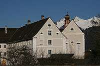
The Bludenz district headquarters are situated in the Castle of Gayenhofen, built in the 18th century.
Population
| Historical population | ||
|---|---|---|
| Year | Pop. | ±% |
| 1869 | 2,466 | — |
| 1880 | 3,151 | +27.8% |
| 1890 | 4,501 | +42.8% |
| 1900 | 5,361 | +19.1% |
| 1910 | 5,870 | +9.5% |
| 1923 | 6,019 | +2.5% |
| 1934 | 7,738 | +28.6% |
| 1939 | 7,738 | +0.0% |
| 1951 | 10,178 | +31.5% |
| 1961 | 11,127 | +9.3% |
| 1971 | 12,273 | +10.3% |
| 1981 | 12,891 | +5.0% |
| 1991 | 13,369 | +3.7% |
| 2001 | 13,701 | +2.5% |
| 2011 | 13,726 | +0.2% |
| 2018 | 14,539 | +5.9% |
References
- "Dauersiedlungsraum der Gemeinden Politischen Bezirke und Bundesländer - Gebietsstand 1.1.2018". Statistics Austria. Retrieved 10 March 2019.
- "Einwohnerzahl 1.1.2018 nach Gemeinden mit Status, Gebietsstand 1.1.2018". Statistics Austria. Retrieved 9 March 2019.
- (in German) Brand website
- (in German) Lech website
- (in German) Fohrenburger website
- (in German) Infos at Bludenz website
External links
![]()
- (in German) Bludenz official website
| Authority control |
|
|---|