Atwood, Colorado
Atwood is an unincorporated community and census-designated place (CDP) in Logan County, Colorado, United States. The population was 133 at the 2010 census.[3][4] The Atwood Post Office has the ZIP Code 80722.[2]
Atwood, Colorado | |
|---|---|
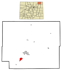 Location in Logan County and the state of Colorado | |
| Coordinates: 40°32′43″N 103°16′25″W | |
| Country | |
| State | |
| County | Logan County |
| Government | |
| • Type | unincorporated community |
| Area | |
| • Total | 1.03 sq mi (2.7 km2) |
| • Land | 1.03 sq mi (2.7 km2) |
| • Water | 0 sq mi (0 km2) |
| Elevation | 3,993 ft (1,217 m) |
| Population (2010) | |
| • Total | 133 |
| • Density | 333/sq mi (128.6/km2) |
| Time zone | UTC-7 (MST) |
| • Summer (DST) | UTC-6 (MDT) |
| ZIP Code | 80722[2] |
| Area code(s) | 970 |
| FIPS code | 08-03840 |
| GNIS feature ID | 0182793 |
A post office called Atwood has been in operation since 1885.[5] The community was named after John Atwood, a Unitarian minister.[6][7]
Geography
Atwood is located in southwestern Logan County at 40°32′43″N 103°16′25″W (40.545166, -103.273615).[8] U.S. Route 6 passes through the community, leading northeast 7 miles (11 km) to Sterling, the county seat, and southwest 6 miles (10 km) to Merino. Colorado State Highway 63 leads south from Atwood 3 miles (5 km) to Exit 115 on Interstate 76 and 27 miles (43 km) to Akron.
According to the United States Census Bureau, the Atwood CDP has a total area of 0.4 square miles (1.0 km2), all of it land.[9]
Climate
This climate type occurs mostly on the outsides of the true deserts, in low-latitude semi-arid steppe regions. The Köppen Climate Classification subtype for this climate is "BSk". (Tropical and Subtropical Steppe Climate).[10]
| Climate data for Atwood, Colorado | |||||||||||||
|---|---|---|---|---|---|---|---|---|---|---|---|---|---|
| Month | Jan | Feb | Mar | Apr | May | Jun | Jul | Aug | Sep | Oct | Nov | Dec | Year |
| Average high °C (°F) | 4 (39) |
6 (43) |
11 (51) |
16 (60) |
21 (70) |
27 (81) |
31 (88) |
31 (87) |
26 (78) |
18 (65) |
10 (50) |
4 (40) |
17 (63) |
| Average low °C (°F) | −10 (14) |
−8 (17) |
−4 (24) |
1 (33) |
6 (43) |
11 (52) |
14 (58) |
14 (57) |
9 (48) |
2 (36) |
−4 (24) |
−9 (16) |
2 (35) |
| Average precipitation mm (inches) | 10 (0.4) |
13 (0.5) |
28 (1.1) |
51 (2) |
71 (2.8) |
66 (2.6) |
66 (2.6) |
53 (2.1) |
30 (1.2) |
25 (1) |
15 (0.6) |
13 (0.5) |
440 (17.4) |
| Source: Weatherbase[11] | |||||||||||||
Demographics
| Historical population | |||
|---|---|---|---|
| Census | Pop. | %± | |
| U.S. Decennial Census[12] | |||
As of the census[4] of 2000, there were 195 people, 72 households, and 58 families residing in the CDP. The population density was 55.0 people per square mile (21.3/km2). There were 81 housing units at an average density of 22.9 per square mile (8.8/km2). The racial makeup of the CDP was 96.41% White, 0.51% African American, 0.51% Native American, and 2.56% from two or more races. Hispanic or Latino of any race were 9.23% of the population.
There were 72 households, out of which 37.5% had children under the age of 18 living with them, 63.9% were married couples living together, 9.7% had a female householder with no husband present, and 19.4% were non-families. 19.4% of all households were made up of individuals, and 9.7% had someone living alone who was 65 years of age or older. The average household size was 2.71 and the average family size was 3.03.
In the CDP, the population was spread out, with 30.3% under the age of 18, 3.6% from 18 to 24, 23.6% from 25 to 44, 31.3% from 45 to 64, and 11.3% who were 65 years of age or older. The median age was 42 years. For every 100 females, there were 95.0 males. For every 100 females age 18 and over, there were 103.0 males.
The median income for a household in the CDP was $44,091, and the median income for a family was $44,205. Males had a median income of $36,375 versus $29,250 for females. The per capita income for the CDP was $21,772. About 7.0% of families and 6.7% of the population were below the poverty line, including 6.3% of those under the age of eighteen and none of those 65 or over.
See also
- Outline of Colorado
- State of Colorado
- Colorado cities and towns
- Colorado census designated places
- Colorado counties
- Colorado metropolitan areas
- Sterling, CO Micropolitan Statistical Area
- Colorado cities and towns
References
- "US Board on Geographic Names". United States Geological Survey. 2007-10-25. Retrieved 2008-01-31.
- "ZIP Code Lookup". United States Postal Service. December 14, 2006. Archived from the original (JavaScript/HTML) on 14 December 2006. Retrieved December 14, 2006.
- Colorado Trend Report 2: State and Complete Places (Sub-state 2010 Census Data). Archived 2012-07-11 at Archive.today Missouri Census Data Center. Accessed 2011-02-25.
- "U.S. Census website". United States Census Bureau. Retrieved 2008-01-31.
- "Post offices". Jim Forte Postal History. Archived from the original on 6 March 2016. Retrieved 22 June 2016.
- Exploring Colorado Highways: Trip Trivia. Exploring America's Highway. 2007. p. 109. ISBN 978-0-9777301-0-0.
- Dawson, John Frank (1954). Place names in Colorado: why 700 communities were so named, 150 of Spanish or Indian origin. Denver, CO: The J. Frank Dawson Publishing Co. p. 7.
- "US Gazetteer files: 2010, 2000, and 1990". United States Census Bureau. 2011-02-12. Retrieved 2011-04-23.
- "Geographic Identifiers: 2010 Census Summary File 1 (G001), Atwood CDP, Colorado". American FactFinder. U.S. Census Bureau. Archived from the original on February 13, 2020. Retrieved October 3, 2019.
- Climate Summary for Atwood, Colorado
- "Weatherbase.com". Weatherbase. 2013. Retrieved on May 8, 2013.
- "Census of Population and Housing". Census.gov. Retrieved June 4, 2016.
External links
| Wikimedia Commons has media related to Atwood, Colorado. |
Municipalities and communities of Logan County, Colorado, United States | ||
|---|---|---|
| City | 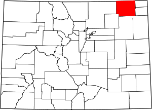 Map of Colorado highlighting Logan County | |
| Towns | ||
| CDPs | ||
| Unincorporated communities | ||