Atsimo-Atsinanana
Atsimo-Atsinanana (South East) is a region in Madagascar. Its capital is Farafangana. The region used to be part of the Fianarantsoa Province.
Atsimo-Atsinanana Region | |
|---|---|
Region | |
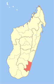 Location in Madagascar | |
| Country | |
| Capital | Farafangana |
| Area | |
| • Total | 18,863 km2 (7,283 sq mi) |
| Population (2018)[1] | |
| • Total | 1,026,674 |
| • Density | 54/km2 (140/sq mi) |
| Time zone | UTC3 (EAT) |
| HDI (2018) | 0.418[2] low · 21st of 22 |
The region extends along the southern part of the east coast of Madagascar. It is bordered by Vatovavy-Fitovinany and Haute Matsiatra (North), Ihorombe (West) and Anosy (South).
The population was 1,026,674 in 2018.[1] It is among the poorest regions in the country, with a poverty rate of 83.9% according to a 2005 government report.[3]
Administrative divisions
Atsimo-Atsinanana region is divided into five districts, which are sub-divided into 90 communes.[4]
- Befotaka Sud District (chief city: Befotaka)
- Farafangana District (Farafangana)
- Midongy-Atsimo District
- Vangaindrano District (Vangaindrano)
- Vondrozo District (Vondrozo)
Transport
Airports
- Farafangana Airport
- Vangaindrano Airport
Protected Areas
- Part of Fandriana-Vondrozo Corridor
- Agnakatrika New Protected Area
- Agnalazaha New Protected Area
- Ankarabolava New Protected Area
- Midongy Atsimo National Park
- Manombo Reserve
See also
References
- "Troisieme Recensement General de la Population et de L'Habitation (RGPH-3) Resultats Provisoires" (PDF). Institut National de la Statistique Madagascar. Retrieved May 23, 2020.
- "Sub-national HDI - Area Database - Global Data Lab". hdi.globaldatalab.org. Retrieved 2018-09-13.
- Republic of Madagascar: Poverty Reduction Strategy Paper Annual Progress Report, International Monetary Fund (August 2006) (IMF Country Report No. 06/303) (poverty data is from 2005 Periodic Household Survey conducted by the Institut National de la Statistique de Madagascar (INSTAT))
- Rapport de mise en oeuvre des Priorites Regionales - Region Atsimo Atsinanana (2010) (pdf includes district and commune map)
This article is issued from Wikipedia. The text is licensed under Creative Commons - Attribution - Sharealike. Additional terms may apply for the media files.