Arkansas Highway 15
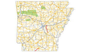
Arkansas Highway 15 (AR 15) is the designation for two state highways in Arkansas.[1] The northern segment of 34.45 miles (55.44 km) runs from Altheimer north across Interstate 40 to Furlow.[2][3] The southern segment of 21.10 miles (33.96 km) is entirely in Union County, and runs from Louisiana Highway 161 north to U.S. Route 82 in El Dorado.[4]
| ||||
|---|---|---|---|---|
 | ||||
| Route information | ||||
| Maintained by ArDOT | ||||
| Existed | 1926–present | |||
| Section 1 | ||||
| Length | 34.45 mi[1] (55.44 km) | |||
| South end | ||||
| North end | ||||
| Section 2 | ||||
| Length | 21.10 mi[1] (33.96 km) | |||
| South end | ||||
| North end | ||||
| Highway system | ||||
| ||||

Route description
Union County
AR 15 begins at Louisiana Highway 161 and runs northeast, cutting through South Arkansas country. The highway serves as a southern terminus for Arkansas Highway 355 outside El Dorado, AR 15 lone junction with another state road. AR 15 next meets the four-lane U.S. Route 82 outside El Dorado, where it terminates.[4]
Altheimer to Furlow
The route begins at US 79 Business and runs north, intersecting Arkansas Highway 31 in Sherrill near the Sherrill Methodist Episcopal Church and the Tucker School in Tucker before entering Lonoke County. Upon entering England, AR 15 forms a concurrency with U.S. Route 165 north to Keo for 5.70 miles (9.17 km).[1] AR 15 continues due north across U.S. Route 70 (near the historic US Route 70 Union Valley segment) and Interstate 40 (AR 15 being exit 169, Remington Rd.) before ending at AR 89/AR 294 west.[3]
Major intersections
| County | Location | mi[1] | km | Destinations | Notes | ||
|---|---|---|---|---|---|---|---|
| Union | | 0.00 | 0.00 | Louisiana state line | |||
| Newell | 16.79 | 27.02 | |||||
| | 21.20 | 34.12 | Interchange; US 82 exit 18 | ||||
| Gap in route | |||||||
| Jefferson | | 0.00 | 0.00 | ||||
| | 5.70 | 9.17 | |||||
| Lonoke | England | 18.12 | 29.16 | ||||
| Gap in route | |||||||
| Keo | 0.00 | 0.00 | |||||
| | 10.93 | 17.59 | |||||
| | 13.69 | 22.03 | I-40 exit 169 | ||||
| Furlow | 16.33 | 26.28 | |||||
| 1.000 mi = 1.609 km; 1.000 km = 0.621 mi | |||||||
History

Arkansas Highway 15 was one of the original 1926 routes designated by the Arkansas Highway Commission. The modern day routes were connected. AR 15 continued east from El Dorado into Bradley County through Hermitage and Warren.[5] The route continued north into Cleveland County through Pansy and into Jefferson County, where it ran through Pine Bluff and along present-day AR 31 north to Sherrill, where it meets with today's routing.[6]
The original 1926 routing ended at AR 36 in England, and no state highway ran to Furlow.[7]
See also
References
- Planning and Research Division (2010). "Arkansas Road Log Database". Arkansas State Highway and Transportation Department. Archived from the original (Database) on 23 June 2011. Retrieved June 9, 2011.
- "Jefferson County, Arkansas." Arkansas State Highway and Transportation Department. AHTD Jefferson County map Retrieved on February 27, 2011.
- "Lonoke County, Arkansas." Arkansas State Highway and Transportation Department. AHTD Lonoke County map Retrieved on February 27, 2011.
- "Union County, Arkansas." Arkansas State Highway and Transportation Department. AHTD Union County map. Retrieved on February 27, 2011.
- "Bradley County, Arkansas showing Arkansas System of State Highways." Updated July 1, 1932. File. Arkansas Highway Commission. Retrieved February 27, 2011.
- "Jefferson County, Arkansas showing Arkansas System of State Highways." Updated 1929. File. Arkansas Highway Commission. Retrieved February 27, 2011.
- "Lonoke County, Arkansas showing Arkansas System of State Highways." Updated July 1, 1935. File. Arkansas Highway Commission. Retrieved February 27, 2011.
External links
![]()