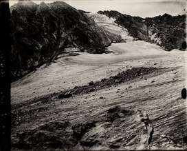
Arapaho Glacier
Arapaho Glacier is an alpine glacier in a cirque immediately southeast of North Arapaho Peak, in Roosevelt National Forest in the U.S. state of Colorado.[3] The glacier is just east of the Continental Divide. Arapaho Glacier is the largest glacier in the state of Colorado and helps provide water for the city of Boulder, Colorado. The glacier has a negative glacier mass balance and lost over 52% of its surface area during the 20th Century.[2]
| Arapaho Glacier | |
|---|---|
 | |
 Arapaho Glacier Location in Colorado | |
| Type | Mountain glacier |
| Location | Boulder County, Colorado, United States |
| Coordinates | 40°01′24″N 105°38′52″W[1] |
| Area | 39 acres (16 ha)[2] |
| Length | .25 mi (0.40 km) long and .50 mi (0.80 km) wide[2] |
| Thickness | 15 ft (4.6 m)[2] |
| Terminus | Talus/proglacial lake |
| Status | Retreating |
External links
References
- "Arapaho Glacier". Geographic Names Information System. United States Geological Survey. Retrieved August 18, 2012.
- "Arapaho Glacier". National Snow and Ice Data Center. Retrieved October 2, 2017. (dead link 28 April 2018)
- Monarch Lake, CO (Map). TopoQwest (United States Geological Survey Maps). Retrieved August 18, 2012.
| Wikimedia Commons has media related to Arapaho Glacier. |
This article is issued from Wikipedia. The text is licensed under Creative Commons - Attribution - Sharealike. Additional terms may apply for the media files.