Araguaína Airport
Araguaína Airport (IATA: AUX, ICAO: SWGN) is the airport serving Araguaína, Brazil.
Araguaína Airport Aeroporto de Araguaína | |||||||||||
|---|---|---|---|---|---|---|---|---|---|---|---|
 | |||||||||||
| Summary | |||||||||||
| Airport type | Public | ||||||||||
| Operator | Esaero | ||||||||||
| Serves | Araguaína | ||||||||||
| Elevation AMSL | 235 m / 771 ft | ||||||||||
| Coordinates | 07°13′42″S 048°14′27″W | ||||||||||
| Map | |||||||||||
 AUX Location in Brazil | |||||||||||
| Runways | |||||||||||
| |||||||||||
It is operated by Esaero.
History
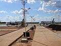
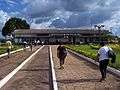
The airport is the main gateway to the Northern region of the state of Tocantins, and Southern region of the states of Pará and Maranhão. Although very basic, the terminal building has a climatized boarding-room capable of handling roughly the number of passengers carried by a Boeing 737-400, with usual passenger amenities.
The airport was renovated, which included the ramp, runway, runway lighting, and the terminal building.
Access
The airport is located 8 km (5 mi) from downtown Araguaína.
See also
References
- "Araguaína Airport Information". World Aero Data.
- "Lista de aeródromos públicos" (in Portuguese). ANAC.
External links
- Airport information for SWGN at World Aero Data. Data current as of October 2006.Source: DAFIF.
- Airport information for SWGN at Great Circle Mapper. Source: DAFIF (effective October 2006).
- Current weather for SWGN at NOAA/NWS
- Accident history for AUX at Aviation Safety Network
Airport pictures
This article is issued from Wikipedia. The text is licensed under Creative Commons - Attribution - Sharealike. Additional terms may apply for the media files.