Ano Pogoni
Ano Pogoni (Greek: Άνω Πωγώνι) is a former municipality in the Ioannina regional unit, Epirus, Greece. Since the 2011 local government reform it is part of the municipality Pogoni, of which it is a municipal unit.[2] The municipal unit has an area of 137.084 km2.[3] Population 1,490 (2011). The seat of the municipality was in Kefalovryso.
Ano Pogoni Άνω Πωγώνι | |
|---|---|
 Ano Pogoni Location within the regional unit 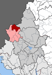 | |
| Coordinates: 40°1′N 20°34′E | |
| Country | Greece |
| Administrative region | Epirus |
| Regional unit | Ioannina |
| Municipality | Pogoni |
| • Municipal unit | 137.084 km2 (52.928 sq mi) |
| Elevation | 650 m (2,130 ft) |
| Population (2011)[1] | |
| • Municipal unit | 1,490 |
| • Municipal unit density | 11/km2 (28/sq mi) |
| Time zone | UTC+2 (EET) |
| • Summer (DST) | UTC+3 (EEST) |
| Postal code | 440 06 |
| Area code(s) | 26570 |
| Vehicle registration | ΙΝ |
Subdivisions
The municipal unit Ano Pogoni is subdivided into the following communities (constituent villages in brackets):
- Agios Kosmas
- Kakolakkos
- Kato Meropi
- Kefalovryso
- Meropi (formerly Roumpates)[4]
- Oraiokastro
- Palaiopyrgos
- Roupsia
- Vasiliko
Population
| Year | Population |
|---|---|
| 1991 | 2,108 |
| 2001 | 1,663 |
| 2011 | 1,490 |
Names
The name Ano Pogoni means "Upper Pogoni". Some Albanian toponyms exist for names of villages in the Pogoni area such as Roumpates meaning robe or garment.[5]
History
During the Balkan Wars (autumn 1912) a number of villages in the area were affected by raids of Muslim bands.[6] At the end of the Balkan Wars most of the Pogoni area became part Greece, while six villages (Lower Pogoni) were ceded to the newly established Principality of Albania.
References
- "Απογραφή Πληθυσμού - Κατοικιών 2011. ΜΟΝΙΜΟΣ Πληθυσμός" (in Greek). Hellenic Statistical Authority.
- Kallikratis law Greece Ministry of Interior (in Greek)
- "Population & housing census 2001 (incl. area and average elevation)" (PDF) (in Greek). National Statistical Service of Greece. Archived from the original (PDF) on 2015-09-21.
- "Πανδέκτης: Roumpátes -- Merópi". Retrieved 2019-10-03. Pandektis: Name Changes of Settlements in Greece, compiled by the Institute for Neohellenic Research
- Ifantis, Nikos Th. (2005). Η Πωγωνιανή - Παλιά Βοστίνα και τα Κοινοτικά Διαμερίσματα Δολό-Δρυμάδες-Σταυροσκιάδι. Διευρυμένη Κοινότητα Πωγωνιανής. p. 45.CS1 maint: ref=harv (link) "όπως και από αλβανικές ονομασίες χωριών: Ρομπάτες (= ρόμπα, ένδυμα), Δελβινακίων (= αμπελότοπος), Γούβερη (Γούβα - Κοίλωμα) κ.λ.π."
- Tsoutsoumpis, Spyros (December 2015). "Violence, resistance and collaboration in a Greek borderland: the case of the Muslim Chams of Epirus "Qualestoria" n. 2, dicembre 2015". Qualestoria: 119–138. Retrieved 14 June 2016.