Altostratus undulatus cloud
The altostratus undulatus is a type of altostratus cloud with signature undulations within it. These undulations may be visible (usually as "wavy bases"), but frequently they are indiscernible to the naked eye. These formations will generally appear in the early stages of destabilizing return flows, especially over the southern plains of the United States, when the surface temperature is still relatively cool.[1] The wavy strips of clouds are generally near an inversion surface.
| Altostratus undulatus cloud | |
|---|---|
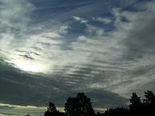 Cirrus and Altostratus undulatus clouds | |
| Abbreviation | As |
| Genus | Alto- (high), -stratus (layered) |
| Species | undulatus (waves) |
| Altitude | 2400-6100 m (8,000-20,000 ft) |
| Classification | Family B (Medium-level) |
| Appearance | Wavy, like ripples in a pond |
| Precipitation cloud? | Usually no |
Also referred to as billow clouds, wind row clouds, or wave clouds, variations of the undulatus can be elements that have merged or single elements that have stretched through the sky. They often run parallel, but can also appear to interweave across the sky, especially if dual wave systems are seen (also referred to as biundulatus).

See also
- Weather
- Atmosphere
- Cloud types
- Undular bore
References
- "Altostratus Undulatus". Stormeyes.org. Archived from the original on 13 October 2008. Retrieved 2008-10-15.
External links
- American Meteorological Society's Glossary of Meteorology
- Stormeyes, a website for storm watchers (and storm chasers)
- Weather Photography