Cirrus cloud
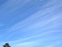
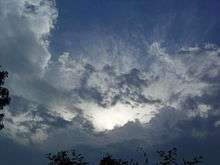
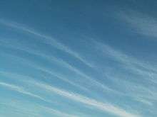
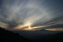
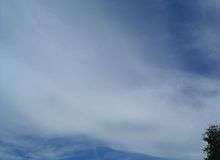
Cirrus (cloud classification symbol: Ci) is a genus of atmospheric cloud generally characterized by thin, wispy strands, giving the type its name from the Latin word cirrus, meaning a ringlet or curling lock of hair.[1] This cloud can form at any altitude between 16,500 ft (5.0 km; 3.13 mi) and 45,000 ft (14 km; 8.5 mi) above sea level. The strands of cloud sometimes appear in tufts of a distinctive form referred to by the common name of "mares' tails".[2]

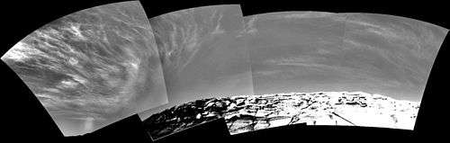
From the surface of Earth, cirrus typically appears white, or a light grey in color. It forms when water vapor undergoes deposition at altitudes above 5,500 m (18,000 ft) in temperate regions and above 6,400 m (21,000 ft) in tropical regions. It also forms from the outflow of tropical cyclones or the anvils of cumulonimbus clouds. Since cirrus clouds arrive in advance of the frontal system or tropical cyclone, it indicates that weather conditions may soon deteriorate. While it indicates the arrival of precipitation (rain), cirrus clouds only produce fall streaks (falling ice crystals that evaporate before landing on the ground).
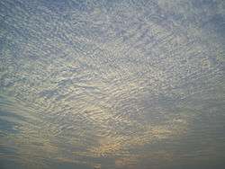
Jet stream-powered cirrus can grow long enough to stretch across continents while remaining only a few kilometers deep.[3] When visible light interacts with the ice crystals in cirrus cloud, it produces optical phenomena such as sun dogs and halos. Cirrus is known to raise the temperature of the air beneath the main cloud layer by an average of 10 °C (18 °F). When the individual filaments become so extensive that they are virtually indistinguishable from one another, they form a sheet of high cloud called cirrostratus. Convection at high altitudes can produce another high-based genus called cirrocumulus, a pattern of small cloud tufts that contain droplets of supercooled water. Some polar stratospheric clouds can resemble cirrus, while noctilucent clouds are typically structured in a way that is similar to cirrus.
Cirrus clouds form on other planets, including Mars, Jupiter, Saturn, Uranus, and Neptune. They have even been seen on Titan, one of Saturn's moons. Some of these extraterrestrial cirrus clouds are composed of ammonia or methane ice rather than water ice. The term cirrus is also used for certain interstellar clouds composed of sub-micrometer-sized dust grains.
Description
Cirrus clouds range in thickness from 100 m (330 ft) to 8,000 m (26,000 ft), with an average thickness of 1,500 m (4,900 ft). There are, on average, 30 ice crystals per liter (96 ice crystals per gallon), but this ranges from one ice crystal per 10,000 liters (3.7 ice crystals per 10,000 gallons) to 10,000 ice crystals per liter (37,000 ice crystals per gallon), a difference of eight orders of magnitude. The length of each of these ice crystals is usually 0.25 millimeters long,[4] but they range from as short as 0.01 millimeters or as long as several millimeters.[5] The ice crystals in contrails are much smaller than those in naturally occurring cirrus cloud, as they are around 0.001 millimeters to 0.1 millimeters in length.[6] Cirrus can vary in temperature from −20 °C (−4 °F) to −30 °C (−22 °F).[5]
The ice crystals in cirrus clouds have different shapes in addition to different sizes. Some shapes include solid columns, hollow columns, plates, rosettes, and conglomerations of the various other types. The shape of the ice crystals is determined by the air temperature, atmospheric pressure, and ice supersaturation. Cirrus in temperate regions typically have the shapes segregated by type: the columns and plates tend to be at the top of the cloud, whereas the rosettes and conglomerations tend to be near the base.[5] In the northern Arctic region, cirrus clouds tend to be composed up of only the columns, plates, and conglomerations, and these crystals tend to be at least four times larger than the minimum size. In Antarctica, cirrus are usually composed of only the columns, and these columns are much longer than normal.[5]

Scientists have studied the characteristics of cirrus using several different methods. One, Light Detection and Ranging (LiDAR), gives highly accurate information on the cloud's altitude, length, and width. Balloon-carried hygrometers give information on the humidity of the cirrus cloud but are not accurate enough to measure the depth of the cloud. Radar units give information on the altitudes and thicknesses of cirrus clouds.[7] Another data source is satellite measurements from the Stratospheric Aerosol and Gas Experiment (SAGE) program. These satellites measure where infrared radiation is absorbed in the atmosphere, and if it is absorbed at cirrus altitudes, then it is assumed that there are cirrus clouds in that location.[8] The United States National Aeronautics and Space Administration's (NASA) MODerate resolution Imaging Spectroradiometer (MODIS) also gives information on the cirrus cloud cover by measuring reflected infrared radiation of various specific frequencies during the day. During the night, it determines cirrus cover by detecting the Earth's infrared emissions. The cloud reflects this radiation back to the ground, thus enabling satellites to see the "shadow" it casts into space.[9] Visual observations from aircraft or the ground provide additional information about cirrus clouds.[8]
Based on data taken from the United States using these methods, cirrus cloud cover was found to vary diurnally and seasonally. The researchers found that in the summer, at noon, the cover is the lowest, with an average of 23% of the United States' land area covered by cirrus. Around midnight, the cloud cover increases to around 28%. In winter, the cirrus cloud cover did not vary appreciably from day to night. These percentages include clear days and nights, as well as days and nights with other cloud types, as lack of cirrus cloud cover. When these clouds are present, the typical coverage ranges from 30% to 50%.[3] Based on satellite data, cirrus covers an average of 20% to 25% of the Earth's surface. In the tropical regions, this cloud covers around 70% of the region's surface area.[5]
Cirrus clouds often produce hair-like filaments—similar to the virga produced in liquid–water clouds—called fall streaks, and they are made of heavier ice crystals that fall from the cloud. The sizes and shapes of fall streaks are determined by the wind shear.[10]
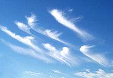
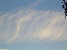
Cirrus comes in four distinct species; Cirrus castellanus, fibratus, spissatus, and uncinus; which are each divided into four varieties: intortus, vertebratus, radiatus, and duplicatus.[11] Cirrus castellanus is a species that has cumuliform tops caused by high-altitude convection rising up from the main cloud body. Cirrus fibratus looks striated and is the most common cirrus species. Cirrus uncinus clouds are hooked and are the form that is usually called mare's tails. Of the varieties, Cirrus intortus has an extremely contorted shape, and cirrus radiatus has large, radial bands of cirrus clouds that stretch across the sky. Kelvin–Helmholtz waves are a form of cirrus intortus that has been twisted into loops by vertical wind shear.[12]
Formation
Cirrus clouds are formed when water vapor undergoes deposition at high altitudes where the atmospheric pressure ranges from 600 mbar at 4,000 m (13,000 ft) above sea level to 200 mbar at 12,000 m (39,000 ft) above sea level.[13] These conditions commonly occur at the leading edge of a warm front.[14] Because humidity is low at such high altitudes, this genus-type tends to be very thin.[2] Cirrus clouds are composed of ice crystals that originate from the freezing of super cooled water droplets in regions where air temperature is lower than -20 °C or -30 °C.Cirrus usually occur in fair weather. They are formed when it is high enough to be cold and freeze the water drops into ice. They sometimes may be caused by turbulence and wind shear, or by upper-tropospheric convection. Sometimes they are like blown out ice-crystals spreading from the top of a dying cumulonimbus.
Cyclones
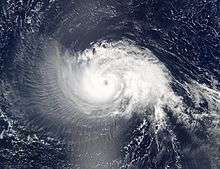
Cirrus forms from tropical cyclones, and is commonly seen fanning out from the eyewalls of hurricanes. A large shield of cirrus and cirrostratus typically accompanies the high altitude outflow of hurricanes or typhoons,[9] and these can make the underlying rain bands—and sometimes even the eye—difficult to detect in satellite photographs.[15]
Thunderstorms
Thunderstorms can form dense cirrus at their tops. As the cumulonimbus cloud in a thunderstorm grows vertically, the liquid water droplets freeze when the air temperature reaches the freezing point.[16] The anvil cloud takes its shape because the temperature inversion at the tropopause prevents the warm, moist air forming the thunderstorm from rising any higher, thus creating the flat top.[17] In the tropics, these thunderstorms occasionally produce copious amounts of cirrus from their anvils.[18] High-altitude winds commonly push this dense mat out into an anvil shape that stretches downwind as much as several kilometers.[17]
Individual cirrus cloud formations can be the remnants of anvil clouds formed by thunderstorms. In the dissipating stage of a cumulonimbus cloud, when the normal column rising up to the anvil has evaporated or dissipated, the mat of cirrus in the anvil is all that is left.[19]
Contrails
Contrails are a manmade type of cirrus cloud formed when water vapor from the exhaust of a jet engine condenses on particles, which come from either the surrounding air or the exhaust itself, and freezes, leaving behind a visible trail. The exhaust can also trigger the formation of cirrus by providing ice nuclei when there is an insufficient naturally-occurring supply in the atmosphere.[6] One of the environmental impacts of aviation is that persistent contrails can form into large mats of cirrus,[20] and increased air traffic has been implicated as one possible cause of the increasing frequency and amount of cirrus in Earth's atmosphere.[20][21]
Use in forecasting
Random, isolated cirrus do not have any particular significance.[14] A large number of cirrus clouds can be a sign of an approaching frontal system or upper air disturbance. This signals a change in weather in the near future, which usually becomes more stormy.[22] If the cloud is a cirrus castellanus, there might be instability at the high altitude level.[14] When the clouds deepen and spread, especially when they are of the cirrus radiatus variety or cirrus fibratus species, this usually indicates an approaching weather front. If it is a warm front, the cirrus clouds spread out into cirrostratus, which then thicken and lower into altocumulus and altostratus. The next set of clouds are the rain-bearing nimbostratus clouds.[1][14][23] When cirrus clouds precede a cold front, squall line or multicellular thunderstorm, it is because they are blown off the anvil, and the next to arrive are the cumulonimbus clouds.[23] Kelvin-Helmholtz waves indicate extreme wind shear at high levels.[14]
Within the tropics, 36 hours prior to the center passage of a tropical cyclone, a veil of white cirrus clouds approaches from the direction of the cyclone.[24] In the mid to late 19th century, forecasters used these cirrus veils to predict the arrival of hurricanes. In the early 1870s the president of Belén College in Havana, Cuba, Father Benito Viñes, developed the first hurricane forecasting system, and he mainly used the motion of these clouds in formulating his predictions.[25] He would observe the clouds hourly from 4:00 am to 10:00 pm. After accumulating enough information, Viñes began accurately predicting the paths of hurricanes, and he eventually summarized his observations in his book, Apuntes Relativos a los Huracanes de las Antilles.[26]
Effects on climate
Cirrus clouds cover nothing to 25% of the Earth (up to 70% in the tropics[27]) and have a net heating effect.[28] When they are thin and translucent, the clouds efficiently absorb outgoing infrared radiation while only marginally reflecting the incoming sunlight.[29] When cirrus clouds are 100 m (330 ft) thick, they reflect only around 9% of the incoming sunlight, but they prevent almost 50% of the outgoing infrared radiation from escaping, thus raising the temperature of the atmosphere beneath the clouds by an average of 10 °C (18 °F)[30]—a process known as the greenhouse effect.[31] Averaged worldwide, cloud formation results in a temperature loss of 5 °C (9 °F) at the earth's surface, mainly the result of stratocumulus clouds.[32]
As a result of their warming effects when relatively thin, cirrus clouds have been implicated as a potential partial cause of global warming.[29] Scientists have speculated that global warming could cause high thin cloud cover to increase, thereby increasing temperatures and humidity. This, in turn, would increase the cirrus cloud cover, effectively creating a positive feedback circuit. A prediction of this hypothesis is that the cirrus would move higher as the temperatures rose, increasing the volume of air underneath the clouds and the amount of infrared radiation reflected back down to earth.[6] In addition, the hypothesis suggests that the increase in temperature would tend to increase the size of the ice crystals in the cirrus cloud, possibly causing the reflection of solar radiation and the reflection of the Earth's infrared radiation to balance out.[6][32]
A similar hypothesis put forth by Richard Lindzen is the iris hypothesis in which an increase in tropical sea surface temperatures results in less cirrus clouds and thus more infrared radiation emitted to space.[33]
Optical phenomena
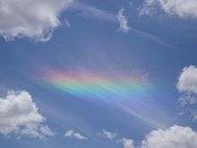
Cirrus clouds, like cirrostratus clouds, can produce several optical effects, such as halos around the sun and moon. Halos are caused by interaction of the light with hexagonal ice crystals present in the clouds, which, depending on their shape and orientation, can result in a wide variety of white and colored rings, arcs and spots in the sky. Common halo varieties are the 22° halo, sun dogs, the circumzenithal arc and the circumhorizontal arc (also known as fire rainbows).[5][34][35] Halos produced by cirrus clouds tend to be more pronounced and colorful than those caused by cirrostratus.
More rarely, cirrus clouds are capable of producing glories, more commonly associated with liquid water-based clouds such as stratus. A glory is a set of concentric, faintly-colored glowing rings that appear around the shadow of the observer, and are best observed from a high viewpoint or from a plane.[36] Cirrus clouds only form glories when the constituent ice crystals are aspherical, and researchers suggest that the ice crystals must be between 0.009 millimeters and 0.015 millimeters in length.[37]
Relation to other clouds
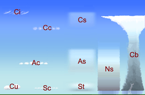
Cirrus clouds are one of three different genera of high-étage (high-level) clouds. High-étage clouds form at 5,000 m (16,500 ft) and above in temperate regions. The other two genera, cirrocumulus and cirrostratus, are also high clouds.
In the intermediate range, from 2,000 m (6,500 ft) to 7,000 m (23,000 ft) in temperate regions, are the mid-étage clouds. They comprise two or three genera depending on the system of height classification being used: altostratus, altocumulus, and, according to WMO classification, nimbostratus. These clouds are formed from ice crystals, supercooled water droplets, or liquid water droplets.[38]
Low-étage clouds form at less than 2,000 m (6,500 ft). The two genera that are strictly low-étage are stratus, and stratocumulus. These clouds are composed of water droplets, except during winter when they are formed of supercooled waterdroplets or ice crystals if the temperature at cloud level is below freezing. Two additional genera usually form in the low altitude range, but may be based at higher levels under conditions of very low humidity. They comprise the genera cumulus, and cumulonimbus, which along with nimbostratus, are often classified separately as clouds of vertical development, especially when their tops are high enough to be composed of super-cooled water droplets or ice crystals.[39]
The altitudes of high-étage clouds like cirrus vary considerably with latitude. In the polar regions, they are at their lowest, with a minimum altitude of only 3,000 m (10,000 ft) to a maximum of 7,600 m (25,000 ft). In tropical regions, they are at their highest, ranging in altitude from about 6,100 m (20,000 ft) to around 18,000 m (60,000 ft). In temperate regions, they range in altitude from 5,000 m (16,500 ft) to 14,000 m (45,000 ft)—a variation in contrast to low-étage clouds, which do not appreciably change altitude with latitude.[38]
Summary of high cloud genera
There are three main genera in the family of high clouds: cirrus, cirrocumulus, and cirrostratus.[40] Cirrostratus clouds commonly produce halos because they are composed almost entirely of ice crystals.[41] Cirrocumulus and cirrostratus are sometimes informally referred to as "cirriform clouds" because of their frequent association with cirrus. They are given the prefix "cirro-", but this refers more to their altitude range than their physical structure. Cirrocumulus in its pure form is actually a high cumuliform genus, and cirrostratus is stratiform, like altostratus and lower based sheet clouds.
Cirrocumulus
Cirrocumulus clouds form in sheets or patches[42] and do not cast shadows. They commonly appear in regular, rippling patterns[40] or in rows of clouds with clear areas between.[1] Cirrocumulus are, like other members of the cumuliform category, formed via convective processes.[43] Significant growth of these patches indicates high-altitude instability and can signal the approach of poorer weather.[44][45] The ice crystals in the bottoms of cirrocumulus clouds tend to be in the form of hexagonal cylinders. They are not solid, but instead tend to have stepped funnels coming in from the ends. Towards the top of the cloud, these crystals have a tendency to clump together.[46] These clouds do not last long, and they tend to change into cirrus because as the water vapor continues to deposit on the ice crystals, they eventually begin to fall, destroying the upward convection. The cloud then dissipates into cirrus.[47] Cirrocumulus clouds come in four species: stratiformis, lenticularis, castellanus, and floccus.[44] They are iridescent when the constituent supercooled water droplets are all about the same size.[45]
Cirrostratus
Cirrostratus clouds can appear as a milky sheen in the sky[44] or as a striated sheet.[40] They are sometimes similar to altostratus and are distinguishable from the latter because the sun or moon is always clearly visible through transparent cirrostratus, in contrast to altostratus which tends to be opaque or translucent.[48] Cirrostratus come in two species, fibratus and nebulosus.[44] The ice crystals in these clouds vary depending upon the height in the cloud. Towards the bottom, at temperatures of around −35 °C (−31 °F) to −45 °C (−49 °F), the crystals tend to be long, solid, hexagonal columns. Towards the top of the cloud, at temperatures of around −47 °C (−53 °F) to −52 °C (−62 °F), the predominant crystal types are thick, hexagonal plates and short, solid, hexagonal columns.[47][49] These clouds commonly produce halos, and sometimes the halo is the only indication that such clouds are present.[50] They are formed by warm, moist air being lifted slowly to a very high altitude.[51] When a warm front approaches, cirrostratus clouds become thicker and descend forming altostratus clouds,[1] and rain usually begins 12 to 24 hours later.[50]
Extraterrestrial
Cirrus clouds have been observed on several other planets. On 18 September 2008, the Martian Lander Phoenix took a time-lapse photograph of a group of cirrus clouds moving across the Martian sky using LiDAR.[52] Near the end of its mission, the Phoenix Lander detected more thin clouds close to the north pole of Mars. Over the course of several days, they thickened, lowered, and eventually began snowing. The total precipitation was only a few thousandths of a millimeter. James Whiteway from York University concluded that "precipitation is a component of the [Martian] hydrologic cycle."[53] These clouds formed during the Martian night in two layers, one around 4,000 m (13,000 ft) above ground and the other at surface level. They lasted through early morning before being burned away by the sun. The crystals in these clouds were formed at a temperature of −65 °C (−85 °F), and they were shaped roughly like ellipsoids 0.127 millimeters long and 0.042 millimeters wide.[54]
On Jupiter, cirrus clouds are composed of ammonia. When Jupiter's South Equatorial Belt disappeared, one hypothesis put forward by Glenn Orten was that a large quantity of ammonia cirrus clouds had formed above it, hiding it from view.[55] NASA's Cassini probe detected these clouds on Saturn[56] and thin water-ice cirrus on Saturn's moon Titan.[57] Cirrus clouds composed of methane ice exist on Uranus.[58] On Neptune, thin wispy clouds which could possibly be cirrus have been detected over the Great Dark Spot. As on Uranus, these are probably methane crystals.[59]
Interstellar cirrus clouds are composed of tiny dust grains smaller than a micrometer and are therefore not true clouds of this genus which are composed of ice crystals or other frozen liquids.[60] They range from a few light years to dozens of light years across. While they are not technically cirrus clouds, the dust clouds are referred to as "cirrus" because of their similarity to the clouds on Earth. They also emit infrared radiation, similar to the way cirrus clouds on Earth reflect heat being radiated out into space.[61]
See also
- Cirrus cloud thinning
- Optical Phenomena (Sun halos)
- Cloud Types
Sources
Footnotes
- Funk, Ted. "Cloud Classifications and Characteristics" (PDF). The Science Corner. National Oceanic and Atmospheric Administration. p. 1. Retrieved 30 January 2011.
- Palmer, Chad (16 October 2005). "USA Today: Cirrus Clouds". USA Today. Retrieved 13 September 2008.
- Dowling & Radke 1990, p. 974
- Dowling & Radke 1990, p. 977
- McGraw-Hill Editorial Staff 2005, p. 1
- McGraw-Hill Editorial Staff 2005, p. 2
- Dowling & Radke 1990, p. 971
- Dowling & Radke 1990, p. 972
- "Cirrus Cloud Detection" (PDF). Satellite Product Tutorials. NASA (NexSat). pp. 2, 3, & 5. Retrieved 29 January 2011.
- "Cirrus Clouds: Thin and Wispy". Cloud Types. Department of Atmospheric Sciences at University of Illinois. Retrieved 29 January 2011.
- "Cirrus – Clouds Online". Retrieved 20 March 2012.
- Audubon 2000, p. 446
- Dowling & Radke 1990, p. 973
- Audubon 2000, p. 447
- "Tropical Cyclone SSMI – Composite Tutorial". United States Navy. Retrieved 18 February 2011.
- Lydolph 1985, p. 122
- Grenci & Nese 2001, p. 212
- "Computer-simulated Thunderstorms with Ice Clouds Reveal Insights for Next-generation Computer Models". Atmospheric Sciences & Global Change Division Research Highlights. Pacific Northwest National Laboratory. December 2009. p. 42. Archived from the original on 14 May 2011. Retrieved 30 January 2011.
- Grenci & Nese 2001, p. 213
- Cook-Anderson, Gretchen; Rink, Chris; Cole, Julia (27 April 2004). "Clouds Caused By Aircraft Exhaust May Warm The U.S. Climate". National Aeronautics and Space Administration. Retrieved 24 June 2011.
- Minnis et al. 2004, p. 1671
- Battan, Louis (1974). Weather. Foundations of Earth Science Series. Englewood Cliffs, New Jersey: Prentice Hall. p. 74. ISBN 978-0-13-947762-1.
- Whiteman 2000, p. 84
- Central Pacific Hurricane Center (23 July 2006). "Tropical Cyclone Observations". National Oceanic and Atmospheric Administration. Retrieved 5 May 2008.
- Sheets 1990, p. 190
- "Father Hurricane". Cable News Network, Inc. 11 March 1998. Archived from the original on 25 July 2011. Retrieved 22 February 2011.
- Lolli, Simone; Campbell, James R.; Lewis, Jasper R.; Gu, Yu; Marquis, Jared W.; Chew, Boon Ning; Liew, Soo-Chin; Salinas, Santo V.; Welton, Ellsworth J. (9 February 2017). "Daytime Top-of-the-Atmosphere Cirrus Cloud Radiative Forcing Properties at Singapore". Journal of Applied Meteorology and Climatology. 56 (5): 1249–1257. Bibcode:2017JApMC..56.1249L. doi:10.1175/JAMC-D-16-0262.1. hdl:11603/17229. ISSN 1558-8424.
- Franks F. (2003). "Nucleation of ice and its management in ecosystems" (PDF). Philosophical Transactions of the Royal Society A. 361 (1804): 557–574. Bibcode:2003RSPTA.361..557F. doi:10.1098/rsta.2002.1141. PMID 12662454.
- Stephens et al. 1990, p. 1742
- Liou 1986, p. 1191
- "Global Warming: Feature Articles". Earth Observatory. National Aeronautics and Space Administration. Retrieved 16 October 2012.
- "Cloud Climatology". International Satellite Cloud Climatology Program. National Aeronautics and Space Administration. Retrieved 12 July 2011.
- Lindzen, R.S.; M.-D. Chou & A.Y. Hou (2001). "Does the Earth have an adaptive infrared iris?" (PDF). Bull. Amer. Meteor. Soc. 82 (3): 417–432. Bibcode:2001BAMS...82..417L. doi:10.1175/1520-0477(2001)082<0417:DTEHAA>2.3.CO;2.
- Gilman, Victoria (19 June 2006). "Photo in the News: Rare "Rainbow" Spotted Over Idaho". National Geographic News. Retrieved 30 January 2011.
- "Fire Rainbows". News & Events. University of the City of Santa Barbara Department of Geology. 29 August 2009. Archived from the original on 12 May 2011. Retrieved 31 January 2011.
- "The Mysterious Glory". The Hong Kong Observatory. Retrieved 27 June 2011.
- Sassen et al. 1998, p. 1433
- "Cloud Classifications". JetStream. National Weather Service. Archived from the original on 10 May 2006. Retrieved 18 June 2011.
- Jim Koermer (2011). "Plymouth State Meteorology Program Cloud Boutique". Plymouth State University. Retrieved 2 April 2012.
- Hubbard & Hubbard 2000, p. 340
- "Weather Glossary – C". Weather Glossary. The Weather Channel. Archived from the original on 17 October 2012. Retrieved 12 February 2011.
- Miyazaki et al. 2001, p. 364
- Parungo 1995, p. 251
- "Common Cloud Names, Shapes, and Altitudes" (PDF). Georgia Institute of Technology. pp. 2, 10–13. Retrieved 12 February 2011.
- Audubon 2000, p. 448
- Parungo 1995, p. 252
- Parungo 1995, p. 254
- Day 2005, p. 56
- Parungo 1995, p. 256
- Ahrens 2006, p. 120
- Hamilton, p. 24
- "Clouds Move Across Mars Horizon". Phoenix Photographs. National Aeronautics and Space Administration. 19 September 2008. Retrieved 15 April 2011.
- Thompson, Andrea (2 July 2009). "How Martian Clouds Create Snowfall". Space.com. NBC News. Retrieved 15 April 2011.
- Whiteway et al. 2009, pp. 68–70
- Phillips, Tony (20 May 2010). "Big Mystery: Jupiter Loses a Stripe". Nasa Headline News – 2010. National Aeronautics and Space Administration. Retrieved 15 April 2011.
- Dougherty & Esposito 2009, p. 118
- "Surprise Hidden in Titan's Smog: Cirrus-Like Clouds". Mission News. National Aeronautics and Space Administration. 3 February 2011. Retrieved 16 April 2011.
- "Uranus". Scholastic. Archived from the original on 2 September 2011. Retrieved 16 April 2011.
- Ahrens 2006, p. 12
- Planck Science Team (2005). Planck: The Scientific Programme (Blue Book) (PDF). ESA-SCI (2005)-1. Version 2. European Space Agency. pp. 123–124. Retrieved 8 July 2009.
- Koupelis 2010, p. 368
Bibliography
- Ahrens, C. Donald (February 2006). Meteorology Today: An Introduction to Weather, Climate, and the Environment (8 ed.). Brooks Cole. ISBN 978-0-495-01162-0. OCLC 693475796.
- Ludlum, David McWilliams (2000). National Audubon Society Field Guide to Weather. Alfred A. Knopf. ISBN 978-0-679-40851-2. OCLC 56559729.
- Day, John A. (August 2005). The Book of Clouds. Sterling. ISBN 978-1-4027-2813-6. OCLC 61240837.
- Dougherty, Michele; Esposito, Larry (November 2009). Saturn from Cassini-Huygens (1 ed.). Springer. ISBN 978-1-4020-9216-9. OCLC 527635272.
- Dowling, David R.; Radke, Lawrence F. (September 1990). "A Summary of the Physical Properties of Cirrus Clouds". Journal of Applied Meteorology. 29 (9): 970. Bibcode:1990JApMe..29..970D. doi:10.1175/1520-0450(1990)029<0970:ASOTPP>2.0.CO;2.
- Grenci, Lee M.; Nese, Jon M. (August 2001). A World of Weather: Fundamentals of Meteorology: A Text / Laboratory Manual (3 ed.). Kendall/Hunt Publishing Company. ISBN 978-0-7872-7716-1. OCLC 51160155.
- Hamilton, Gina (1 September 2007). Blue Planet – Air (eBook). Milliken Publishing. ISBN 978-1-4291-1613-8.
- Hubbard, Richard; Hubbard, Richard Keith (5 May 2000). "Glossary". Boater's Bowditch: The Small Craft American Practical Navigator (2 ed.). International Marine/Ragged Mountain Press. ISBN 978-0-07-136136-1.
- Koupelis, Theo (February 2010). In Quest of the Universe (6 ed.). Jones & Bartlett Publishers. ISBN 978-0-7637-6858-4. OCLC 489012016.
- Liou, Kuo-Nan (June 1986). "Influence of Cirrus Clouds on Weather and Climate Processes: A Global Perspective" (PDF). Monthly Weather Review. 114 (6): 1167–1199. Bibcode:1986MWRv..114.1167L. doi:10.1175/1520-0493(1986)114<1167:IOCCOW>2.0.CO;2. OCLC 4645992610.
- Lydolph, Paul E. (January 1985). The Climate of The Earth. Rowman and Allenheld. p. 122. ISBN 978-0-86598-119-5. OCLC 300400246.
- McGraw-Hill Editorial Staff (2005). McGraw-Hill Yearbook of Science & Technology for 2005 (PDF). McGraw-Hill Companies, Inc. ISBN 978-0-07-144504-7. Archived from the original (PDF) on 6 October 2008.
- Minnis, Patrick; Ayers, J. Kirk; Palikonda, Rabindra; Phan, Dung (April 2004). "Contrails, Cirrus Trends, and Climate". Journal of Climate. 17 (8): 1671. Bibcode:2004JCli...17.1671M. doi:10.1175/1520-0442(2004)017<1671:CCTAC>2.0.CO;2.
- Miyazaki, Ryo; Yoshida, Satoru; Dobashit, Yoshinori; Nishita, Tomoyula (2001). "A method for modeling clouds based on atmospheric fluid dynamics". Proceedings Ninth Pacific Conference on Computer Graphics and Applications. Pacific Graphics 2001. p. 363. CiteSeerX 10.1.1.76.7428. doi:10.1109/PCCGA.2001.962893. ISBN 978-0-7695-1227-3.
- Parungo, F. (May 1995). "Ice Crystals in High Clouds and Contrails". Atmospheric Research. 38 (1–4): 249–262. Bibcode:1995AtmRe..38..249P. doi:10.1016/0169-8095(94)00096-V. OCLC 90987092.
- Sassen, Kenneth; Arnott, W. Patrick; Barnett, Jennifer M.; Aulenbach, Steve (March 1998). "Can Cirrus Clouds Produce Glories?" (PDF). Applied Optics. 37 (9): 1427–33. Bibcode:1998ApOpt..37.1427S. CiteSeerX 10.1.1.21.1512. doi:10.1364/AO.37.001427. OCLC 264468338. PMID 18268731. Archived from the original (PDF) on 21 June 2004. Retrieved 29 January 2011.
- Sheets, Robert C. (June 1990). "The National Hurricane Center—Past, Present and Future". Weather and Forecasting. 5 (2): 185–232. Bibcode:1990WtFor...5..185S. doi:10.1175/1520-0434(1990)005<0185:TNHCPA>2.0.CO;2.
- Stephens, Graeme L.; Tsay, Si-Chee; Stackhouse, Paul W. Jr.; Flatau, Piotr J. (July 1990). "The Relevance of the Microphysical and Radiative Properties of Cirrus Clouds to Climate and Climatic Feedback". Journal of the Atmospheric Sciences. 47 (14): 1742. Bibcode:1990JAtS...47.1742S. doi:10.1175/1520-0469(1990)047<1742:TROTMA>2.0.CO;2.
- Whiteman, Charles David (May 2000). Mountain Meteorology: Fundamentals and Applications (1 ed.). Oxford University Press, USA. ISBN 978-0-19-513271-7. OCLC 41002851.
- Whiteway, J. A.; Komguem, L.; Dickinson, C.; Cook, C.; Illnicki, M.; Seabrook, J.; Popovici, V.; Duck, T. J.; Davy, R.; Taylor, P. A.; Pathak, J.; Fisher, D.; Carswell, A. I.; Daly, M.; Hipkin, V.; Zent, A. P.; Hecht, M. H.; Wood, S. E.; Tamppari, L. K.; Renno, N.; Moores, J. E.; Lemmon, M. T.; Daerden, F.; Smith, P. H. (3 July 2009). "Mars Water-Ice Clouds and Precipitation". Science Magazine. 325 (5936): 68–70. Bibcode:2009Sci...325...68W. CiteSeerX 10.1.1.1032.6898. doi:10.1126/science.1172344. PMID 19574386.
External links
| Wikimedia Commons has media related to Cirrus clouds. |