Alto Alegre, Roraima
Alto Alegre is a city in the Brazilian state of Roraima. The population in 2015 was 16,176, and the area is 25,567 km².[1] Its limits are Amajari to the north, Boa Vista in the east, Mucajaí and Iracema in the south, and Venezuela in the west.
Alto Alegre | |
|---|---|
 Flag  Coat of arms | |
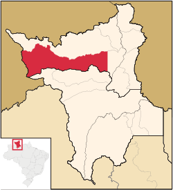 Location in Roraima state | |
 Alto Alegre Location in Brazil | |
| Coordinates: 2°59′16″N 61°18′16″W | |
| Country | Brazil |
| Region | North |
| State | Roraima |
| Government | |
| • Mayor | Pedro Henrique Machado (PSD) |
| Area | |
| • Total | 25,567 km2 (9,871 sq mi) |
| Population (2015) | |
| • Total | 16,176 |
| • Density | 0.63/km2 (1.6/sq mi) |
| Time zone | UTC-04:00 (BRT-1) |
The municipality contains part of the Roraima National Forest.[2]
References
- "IBGE | Cidades | Roraima | Alto Alegre". cidades.ibge.gov.br. Retrieved 2016-06-15.
- Características da UC (in Portuguese), ICMBio, retrieved 2016-05-19
Capital: Boa Vista | ||
| Boa Vista | 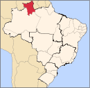 | |
| Nordeste de Roraima | ||
| Caracarai | ||
| Sudeste de Roraima | ||
This article is issued from Wikipedia. The text is licensed under Creative Commons - Attribution - Sharealike. Additional terms may apply for the media files.