Alexandra, Queensland
Alexandra is a rural suburb of Mackay in the Mackay Region, Queensland, Australia.[1]
| Alexandra Mackay, Queensland | |||||||||||||||
|---|---|---|---|---|---|---|---|---|---|---|---|---|---|---|---|
 Alexandra sugar mill | |||||||||||||||
 Alexandra | |||||||||||||||
| Coordinates | 21.1580°S 149.0902°E | ||||||||||||||
| Postcode(s) | 4740 | ||||||||||||||
| Area | 7.5 km2 (2.9 sq mi) | ||||||||||||||
| LGA(s) | Mackay Region | ||||||||||||||
| State electorate(s) | Mirani | ||||||||||||||
| Federal Division(s) | Capricornia | ||||||||||||||
| |||||||||||||||
Geography
Alexandra is flat low-lying land bordered to the north by the Pioneer River and to the south by Bakers Creek. The Peak Downs Highway passes from east to west through the centre of the locality; there is a junction with the Mackay Eungella Road which exits the locality in the north-west. Most of the housing is clustered around these two roads. Most of the land in the suburb is used for sugarcane farming.[2]
The Finch Hatton branch of the Mackay Railway ran through the locality from east to west.[2] After the closure of the railway, a sugarcane tramways replaced it to provide transport for the harvested sugarcane from the canefields to the sugar mills.[3]
History
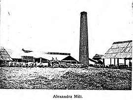
The suburb's name is taken from the Alexandra sugar mill. The mill, in turn, was named by mill owner Thomas Henry Fitzgerald after Princess Alexandra of Denmark who married Prince Edward (later King Edward VII) of Great Britain on 10 March 1863.[1]
The mill was constructed in 1868 and was the largest sugar mill in Queensland. It operated until 1884.[4]
See also
References
- "Alexandra - suburb in Mackay Region (entry 46752)". Queensland Place Names. Queensland Government. Retrieved 27 July 2017.
- "Queensland Globe". State of Queensland. Retrieved 27 July 2017.
- "Finch Hatton Railway Station (entry 600985)". Queensland Heritage Register. Queensland Heritage Council. Retrieved 1 August 2014.
- Hall, Glen (18 July 2017). "Alexandra Sugar Mill". Mackay History. Archived from the original on 27 July 2017. Retrieved 27 July 2017.