Alashan Plateau semi-desert
The Alashan Plateau semi-desert ecoregion (WWF ID:PA1302) covers the south-western portion of the Gobi Desert where precipitation in the mountains is sufficient for a short part of the summer to support sparse plant life. The terrain is basin and range, with elevations from 1,000 to 2,500 metres (3,300 to 8,200 ft). The region straddles the China-Mongolian border, with the Tibetan Plateau to the south, and the more arid regions of the Gobi to the north and east.[1][2]
| Alashan Plateau semi-desert | |
|---|---|
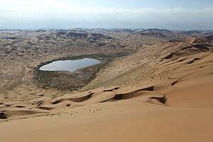 View from Bilutu Peak | |
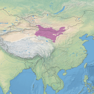 Ecoregion territory (in purple) | |
| Ecology | |
| Realm | Palearctic |
| Biome | Deserts and xeric shrublands |
| Geography | |
| Area | 673,397 km2 (260,000 sq mi) |
| Country | China, Mongolia |
| Coordinates | 40°45′N 100°30′E |
Location and description
The ecoregion encompasses the desert basins and low mountains bordered by the Lop Desert on the west, the Tibetan Plateau and Qilian Mountains to the south, the Gobi extension of the Altai Mountains on the north, and the Helan Mountains to the southeast. This part of the Gobi desert is in the rain shadow of the Tibetan Plateau, but parts of it still receives enough precipitation to support areas of semi-arid-desert plant communities.[3]
Climate
The climate of the ecoregion is Cold semi-arid climate (Köppen climate classification (BSk)). This climate is characteristic of steppe climates intermediary between desert humid climates, and typically have precipitation above evapotranspiration. At least one month averages below 0 °C (32 °F).[4][5] Annual precipitation on the Alashan Plateau is under 150 mm/year.
Flora and fauna
Plant communities of the Alashan Plateau use various strategies to form and survive. While the ecoregion does have areas of sand and bare rock, there are also low-lying areas with plants that are salt-tolerant (Halophytes), and adapted to the low levels of precipitation (Xerophytes). Shrubs such as Saxaul (Haloxylon ammodendron) and the semi-perennial Reaumuria soongorica add stability to the soil and attract associated species. Areas with more moisture support semi-desert communities of wormwoods (Artemisia (genus), beancaper (Zygophyllum), and Calligonum mongolicum. Runoff from the Qilian Mountains support some grasslands, and the Yellow River, which runs along the eastern edge, supports river forests of desert poplar (Populus euphratica) and Tamarix.[1]
There is one mammal endemic to the Alashan Plateau, the Przewalski's gerbil.
Protections
The Gobi Gurvansaikhan National Park is in the north central part of the ecoregion, in Mongolia.
References
- "Alashan Plateau semi-desert". World Wildlife Federation. Retrieved February 23, 2020.
- "Map of Ecoregions 2017". Resolve, using WWF data. Retrieved September 14, 2019.
- Walker, J.S. (July–August 1982). "Deserts of China: Deserts now make up more than 13 percent of the land area in China,and various methods are being used to transform them into farmland". American Scientist. Sigma Xi, The Scientific Research Honor Society (JSTOR). 70 (4): 366–376. JSTOR 27851544.
- Kottek, M., J. Grieser, C. Beck, B. Rudolf, and F. Rubel, 2006. "World Map of Koppen-Geiger Climate Classification Updated" (PDF). Gebrüder Borntraeger 2006. Retrieved September 14, 2019.CS1 maint: multiple names: authors list (link)
- "Dataset - Koppen climate classifications". World Bank. Retrieved September 14, 2019.