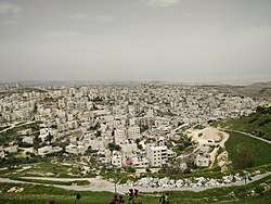
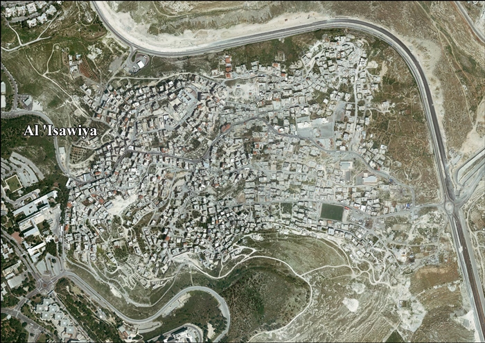
Isawiya
Al-Issawiya (Arabic: العيساوية, is a Palestinian neighborhood in East Jerusalem.[1] It is located on the eastern slopes of the Mount Scopus ridge. To the east and north, it is bordered by Route 1, which connects Jerusalem with the settlement of Ma’ale Adumim; immediately adjoining it to the north, west and southwest are the Hadassah Medical Center, the Hebrew University campus, the Jewish neighborhoods of French Hill and the Ofarit military base; to the south, there is a planned park (the Mount Scopus slopes national park).[2]
_location_map.jpg)
Etymology
Orientalist and Explorer Edward Henry Palmer thought that the name meant "the place or sect of Jesus (ʿIsa)."[3]
History
A burial cave, with pottery dating to the Early Roman period (first century CE), has been found at Isawiya.[4]
Two burial chambers were documented in 2003, one dating to the Roman period, the other to the Byzantine era (sixth–eighth centuries CE).[5] A burial cave with a 4 line inscription in Greek have been examined, the inscription ascribes the tomb to the daughters of the Kyros family.[6]
Ottoman era
Isawiya, like the rest of Palestine, was incorporated into the Ottoman Empire in 1517, and in the 1560s the revenues of al-Isawiya were designated for the waqf of Hasseki Sultan Imaret in Jerusalem, established by Hasseki Hurrem Sultan (Roxelana), wife of Suleiman the Magnificent.[7] In the 1596 tax registers it appeared as Isawiyya, in the Nahiya of Quds of the Liwa of Quds, with a population of 35 households and 3 bachelors, all Muslim. The villages paid a fixed tax-rate of 33.3% on wheat, barley, olive trees, vineyards, fruit trees, goats and beehives; a total of 6,940 akçe.[8][9]
In 1838 it was noted as "a little village",[10] located in the el Wadiyeh region, east of Jerusalem.[11] An Ottoman village list from about 1870 found that Isawiya had a population of 178, (or 78), in 29 houses, though the population count included only men.[12][13]
In 1883, the Palestine Exploration Fund's Survey of Western Palestine described El Aisawiyeh as a "small village on the eastern slope of the chain of Olivet, with a spring to the south and a few olives round it."[14] Another source states the locals grew vegetables, which were sold in Jerusalem.[15]
In 1896 the population was estimated to be about 210 persons.[16]
British Mandate era
In the 1922 census of Palestine, conducted by the British Mandate authorities, 'Isawiyeh had a population of 333, all Muslims,[17] increasing in the 1931 census to a population of 558; 7 Christians and the rest Muslim, occupying 117 houses.[18]
In the 1945 statistics the population of Isawiya was 730; 720 Muslims and 10 Christians,[19] who owned 10,108 dunams of land while 235 dunams had Jewish owners, according to an official land and population survey.[20] 3,291 dunams were used for cereals,[21] while 47 dunams were built-up (urban) land.[22]
1948-1967
The Mount Scopus Agreement signed on July 7, 1948 regulated the demilitarised zone and authorized the United Nations Truce Supervision Organization to settle disputes between Israel and Jordan. One area of conflict involved two Jewish-owned plots in Issawiya, known as Gan Shlomit or Salomons Garden, which were purchased by V.F. Salomons in 1934 and sold to the Gan Shlomit Company, Ltd. in 1937.[23]
In 1961, the population was 1,163, according to a Jordanian census.[24]
In 1964, Issawiya had a population of 1,300. It was located at this time within the Mount Scopus demilitarized zone, an unsupervised demilitarized zone between Jordan and Israel.[25]
Post-1967
Isawiya has been occupied by Israel since the Six-Day War in 1967.
According to ARIJ, Issawiya had 1,212 dunums of land confiscated by Israel in order to construct various Israeli settlements and expand the Hebrew University:
- 568 dunums for the Hebrew University in 1968,[26]
- 394 dunums for Giv’at Shappira (French Hill) in 1968,[26]
- 248 dunums for Mishr Adummim in 1974,[26]
- 2 dunums for Ma’ale Adummim in 1975.[26]
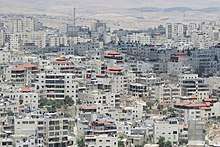
Issawiya is located at the foot of French Hill, northwest of the road to Ma'ale Adumim.[27] Under the jurisdiction of the Jerusalem Municipality, its citizens are considered permanent residents of the city, entitled to live and work in Israel without special permits. As permanent residents, they are also entitled to social benefits provided by Bituah Leumi (Israeli National Insurance Institute) and Israeli health insurance.[28] According to B'tselem, citing community leaders, the population is some 22,000 people while planners commissioned by the municipality and the local leadership say there are 3,700 to 4,000 apartments. The average population density is 25 people per dunam, almost three times the 8.9 in French Hill and 3.5 times the average population density in Jerusalem.[2]
Land registry
Under Jordanian rule, land in Issawiya was registered under the owner's name, but registration stopped in 1967. Residents who apply for building permits are frequently turned down because ownership cannot be proven. Another problem is that land may belong to as many as ten clans. The land would need to be unified and then divided between all residents who claim ownership.
Education
According to the local mukhtar, 800 students in al-Issawiya lack classrooms. This has caused strikes among the students and protests among community leaders and parents. According to the Association for Civil Rights in Israel the difference in schooling-standard between East and West Jerusalem is "staggering".[29] A girls' school in al-Issawiya is one of five elementary schools in the Jerusalem area that teach philosophy to third-graders as part of a program operating in 70 countries.[30] A project sponsored by the Hebrew University of Jerusalem coordinates educational work with youth in Issawiya. Palestinian-Israeli students at the university undergo a training seminar that provides them with the requisite teaching and facilitation skills.[31]
Economy
Some residents of the neighborhood work at Hadassah Medical Center, located on a hill overlooking the neighborhood.[28]
Sports
In 2005, the Peres Center for Peace inaugurated a synthetic turf soccer field in Issawiya as part of the Twinned Peace Soccer School project.[32] The soccer field was a priority in 1993 during Teddy Kollek's election year and had been allocated funding at the time, but was finally built with South Korean funding.[33]
2019 and 2020 clashes
As of May 2020, for over a year, Special Patrol Unit and Border Police forces regularly enter the neighborhood for no real reason.[34][35] Given the purpose, intensity and modality of these operations, they may amount to collective punishment according to human rights organizations.[36]
References
- "The Jerusalem Blowback in Palestine: Not What You'd Think". The Daily Beast. 2017-12-15. Retrieved 2019-05-31.
- B'tselem 2020, p. 3.
- Palmer, 1881, p. 283
- ‘Adawi and Abu Raya, 2005, Jerusalem, ‘Issawiya, Final Report
- ‘Adawi, 2009, Jerusalem, Issawiya
- Re'em and Abu Raya, 2007, Jerusalem, ‘Issawiya
- Singer, 2002, p. 126.
- Hütteroth and Abdulfattah, 1977, p. 122
- Toledano, 1984, p. 289, has Ayzariyya at location 31°46′20″N 35°14′55″E.
- Robinson and Smith, 1841, vol 2, p. 198
- Robinson and Smith, 1841, vol 3, 2nd appendix, p. 122
- Socin, 1879, p. 155
- Hartmann, 1883, p. 124, noted 30 houses
- Conder and Kitchener, 1883, SWP III, p. 27
- Ben-Arieh, Yehoshua. The Sanjak of Jerusalem in the 1870s.‘ in Cathedra, 36. Jerusalem: Yad Yitzhak Ben Zvi. 1985. p. 76
- Schick, 1896, p. 121
- Barron, 1923, Table VII, Sub-district of Jerusalem, p. 14
- Mills, 1932, p. 40
- Government of Palestine, Department of Statistics, 1945, p. 24
- Government of Palestine, Department of Statistics. Village Statistics, April, 1945. Quoted in Hadawi, 1970, p. 57
- Government of Palestine, Department of Statistics. Village Statistics, April, 1945. Quoted in Hadawi, 1970, p. 102
- Government of Palestine, Department of Statistics. Village Statistics, April, 1945. Quoted in Hadawi, 1970, p. 152
- Note by the Secretary-General, Addendum, Corrigendum, Report of the Firing Incident of May 26, 1958 on Mount Scopus; UN Doc S/4030 17 June 1958
- Government of Jordan, Department of Statistics, 1964, p. 23
- "In No Man's Land", Newsweek, Volume 64, Part 2, p.52
- 'Isawiya Town Profile, ARIJ, 2012, p. 14
- Jerusalem Municipality advancing plan to build 1,900 apartments for Arabs
- Bridge Over Troubled Land
- Isawiya students strike over classroom deficit, 08/30/2012 Jerusalem Post
- Ha'aretz pdf article Archived March 5, 2009, at the Wayback Machine
- "Campus-Community Partnership". Archived from the original on 2011-10-02. Retrieved 2011-04-04.
- Peres Center opens Issawiya soccer field YNet News.
- Amir S. Cheshin, Bill Hutman, AVI Melamed (2001) Separate and Unequal: The Inside Story of Israeli Rule in East Jerusalem Harvard University Press, ISBN 0-674-00553-8 p.73
- B'tselem 2020, p. 16.
- "The Baffling Siege of Issawiya". Foundation for Middle East Peace. December 4, 2019. Retrieved May 20, 2020.
- "Daily police raids and clashes result in casualties and disruption of daily life in East Jerusalem neighbourhood". UN. September 6, 2019. Retrieved May 20, 2020.
Bibliography
- ‘Adawi, Zubair; Abu Raya, Rafeh (2005-03-10). "Jerusalem, 'Issawiya, Final Report" (117). Hadashot Arkheologiyot – Excavations and Surveys in Israel. Cite journal requires
|journal=(help) - ‘Adawi, Zubair (2009-12-22). "Jerusalem, 'Issawiya, Final Report" (121). Hadashot Arkheologiyot – Excavations and Surveys in Israel. Cite journal requires
|journal=(help) - ‘Adawi, Zubair (2012-02-09). "Jerusalem, 'Issawiya, Final Report" (124). Hadashot Arkheologiyot – Excavations and Surveys in Israel. Cite journal requires
|journal=(help) - ‘Adawi, Zubair; Barda, Leticia; Dagan, Yehuda (2013-12-31). "Jerusalem, 'Issawiya, Final Report" (125). Hadashot Arkheologiyot – Excavations and Surveys in Israel. Cite journal requires
|journal=(help) - Barron, J.B., ed. (1923). Palestine: Report and General Abstracts of the Census of 1922. Government of Palestine.
- B'tselem (May 2020). This is Jerusalem: Violence and Dispossession in al-‘Esawiyah (PDF) (Report). B'tselem. Retrieved May 19, 2020.
- Conder, C.R.; Kitchener, H.H. (1883). The Survey of Western Palestine: Memoirs of the Topography, Orography, Hydrography, and Archaeology. 3. London: Committee of the Palestine Exploration Fund.
- Government of Jordan, Department of Statistics (1964). First Census of Population and Housing. Volume I: Final Tables; General Characteristics of the Population (PDF).
- Government of Palestine, Department of Statistics (1945). Village Statistics, April, 1945.
- Hadawi, S. (1970). Village Statistics of 1945: A Classification of Land and Area ownership in Palestine. Palestine Liberation Organization Research Centre.
- Hartmann, M. (1883). "Die Ortschaftenliste des Liwa Jerusalem in dem türkischen Staatskalender für Syrien auf das Jahr 1288 der Flucht (1871)". Zeitschrift des Deutschen Palästina-Vereins. 6: 102–149.
- Hill, Gray (1899). "A remarkable cistern and newly discovered spring as Aisawiyeh". Quarterly statement - Palestine Exploration Fund. 31: 45–46.
- Hütteroth, Wolf-Dieter; Abdulfattah, Kamal (1977). Historical Geography of Palestine, Transjordan and Southern Syria in the Late 16th Century. Erlanger Geographische Arbeiten, Sonderband 5. Erlangen, Germany: Vorstand der Fränkischen Geographischen Gesellschaft. ISBN 3-920405-41-2.
- Mills, E., ed. (1932). Census of Palestine 1931. Population of Villages, Towns and Administrative Areas. Jerusalem: Government of Palestine.
- Palmer, E.H. (1881). The Survey of Western Palestine: Arabic and English Name Lists Collected During the Survey by Lieutenants Conder and Kitchener, R. E. Transliterated and Explained by E.H. Palmer. Committee of the Palestine Exploration Fund.
- Re'em, Amit; Abu Raya, Rafeh (2007-03-11). "Jerusalem, 'Issawiya" (119). Hadashot Arkheologiyot – Excavations and Surveys in Israel. Cite journal requires
|journal=(help) - Robinson, E.; Smith, E. (1841). Biblical Researches in Palestine, Mount Sinai and Arabia Petraea: A Journal of Travels in the year 1838. 2. Boston: Crocker & Brewster.
- Robinson, E.; Smith, E. (1841). Biblical Researches in Palestine, Mount Sinai and Arabia Petraea: A Journal of Travels in the year 1838. 3. Boston: Crocker & Brewster.
- Schick, C. (1896). "Zur Einwohnerzahl des Bezirks Jerusalem". Zeitschrift des Deutschen Palästina-Vereins. 19: 120–127.
- Singer, A. (2002). Constructing Ottoman Beneficence: An Imperial Soup Kitchen in Jerusalem. Albany: State University of New York Press. ISBN 0-7914-5352-9.
- Socin, A. (1879). "Alphabetisches Verzeichniss von Ortschaften des Paschalik Jerusalem". Zeitschrift des Deutschen Palästina-Vereins. 2: 135–163.
- Toledano, E. (1984). "The Sanjaq of Jerusalem in the Sixteenth Century: Aspects of Topography and Population". Archivum Ottomanicum. 9: 279–319.
External links
- Survey of Western Palestine, Map 17: IAA, Wikimedia commons
- 'Isawiya Town (Fact Sheet), Applied Research Institute–Jerusalem (ARIJ)
- 'Isawiya Town Profile, ARIJ
- 'Isawiya aerial photo, ARIJ
- Locality Development Priorities and Needs in 'Isawiya, ARIJ
- The new Jerusalem Master Plan grabs 250 dunums of 'Issawiya village lands 01, December, 2004, ARIJ
- Israel expands an Army Military Base East of Al 'Isawiya village 05, July, 2007, POICA
- Transferring 660 Dunums into a "Jewish National Park" in Al 'Isawiya town 04, March, 2010, POICA
- More "Biblical Parks"… the confiscation of Al 'Isawiya and At Tur lands 07, December, 2011, POICA
Neighborhoods of Jerusalem | ||
|---|---|---|
Jerusalem neighborhoods in East Jerusalem are depicted in green, those in West Jerusalem in blue (see Green Line). | ||
| Old City |  | |
| Central Neighborhoods |
| |
| Northern Neighborhoods | ||
| Eastern Neighborhoods | ||
| Southern Neighborhoods | ||
| Western Neighborhoods | ||
| Historical Neighborhoods | ||
| ||