Abu Kamal District
Abu Kamal District (Arabic: منطقة البوكمال, romanized: manṭiqat Albūkamāl) is a district of the Deir ez-Zor Governorate in Northeastern Syria. The administrative centre is the city of Abu Kamal. At the 2004 census, the district had a population of 265,142.[1]
Abu Kamal District منطقة البوكمال | |
|---|---|
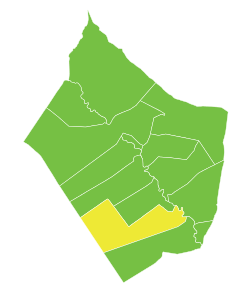
 Map of Abu Kamal District within Deir ez-Zor Governorate | |
| Coordinates (Abu Kamal): 34.45°N 40.93°E | |
| Country | |
| Governorate | Deir ez-Zor |
| Seat | Abu Kamal |
| Subdistricts | 4 nawāḥī |
| Area | |
| • Total | 6,807.01 km2 (2,628.20 sq mi) |
| Population (2004)[1] | |
| • Total | 265,142 |
| • Density | 39/km2 (100/sq mi) |
| Geocode | SY0902 |
The Euphrates divides the district, with Hajin and As-Souseh subdistricts being part of Jazira (Upper Mesopotamia) while Abu Kamal and Al-Jalaa subdistricts are part of the Shamiyah (the Syrian Desert).[2][3] Abu Kamal is an economically prosperous farming region with cattle-breeding, cereals, and cotton crops. It is also home to the historical site Dura-Europos and the ancient kingdom of Mari.


Subdistricts
The district of Abu Kamal is divided into four subdistricts or nawāḥī (population as of 2004[1]):
References
- "2004 Census Data". UN OCHA. Retrieved 15 October 2015.
- Musallam, Basim; ed. by Martha Mundy (2000). The transformation of nomadic society in the Arab East (1. publ. ed.). Cambridge, England: Cambridge University Press. p. 64. ISBN 978-0-521-77057-6.CS1 maint: extra text: authors list (link) (NB The region Shamiyah is used by McIntosh to mean the Syrian Desert, or part thereof)
- McIntosh, Jane (2005). "Shamiyah+desert" Ancient Mesopotamia: New Perspectives. Santa Barbara: ABC-CLIO. p. 11. ISBN 978-1-57607-965-2. Retrieved 3 February 2017.
- "Abu Kamal nahiyah population". Cbssyr.org. Retrieved 2012-06-18.
- "Hajin nahiyah population". Cbssyr.org. Archived from the original on 2013-01-12. Retrieved 2012-06-18.
- "Al-Jalaa nahiyah population". Cbssyr.org. Retrieved 2012-06-18.
- "As-Souseh nahiyah population". Cbssyr.org. Retrieved 2012-06-18.