Abu Dhalouf
Abu Dhalouf (Arabic: أبو ظلوف, romanized: Abū Ḑalūf) is a town on the north coast of Qatar, located in the municipality of Al Shamal.[2][3] It was demarcated in 1988 and is bounded by Madinat ash Shamal to the immediate east, with Ar Ru'ays located to the immediate east of Madinat ash Shamal.[4]
Abu Dhalouf أبو ظلوف | |
|---|---|
Town | |
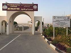 Entrance to Abu Dhalouf Park | |
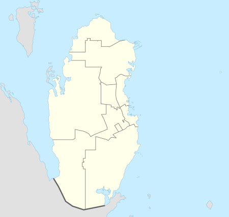 Abu Dhalouf Location in Qatar | |
| Coordinates: 26°7′25″N 51°10′0″E | |
| Country | |
| Municipality | Al Shamal |
| Zone | Zone 78 |
| District no. | 396 |
| Area | |
| • Total | 2.0 sq mi (5.2 km2) |
Etymology
In Arabic, 'abu' means 'father' and in this context is used to describe an area with a distinct feature. 'Dhalouf' is derived from the Arabic term 'dhalfa', which is the name given to the curved ends of saddles used for camel riding. It was so-named because of a prominent hill that resembled the end of a saddle.[5]
Alternative transliterations of the name are Abu Dhaluf,[6] Abū Ḑalūf,[7] Abu Dhuluf,[8] and Abū Z̧ulūf.[9]
History
In the 1820s, George Barnes Brucks was tasked with preparing the first British survey of the Persian Gulf.[10] He wrote down the following notes about Abu Dhalouf, which he referred to as Boodeshoof:
"Boodeshoof, in lat. 26° 7' 50' N., long. 51° 16' E., is on the point nearly opposite Ras Reccan, and is subject to Bahrein, having about fifty men of the Abookara Tribe, mostly fishermen."[11]
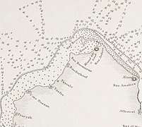 Abu Dhalouf as Boodeshoof in an 1824 map of the Qatar Peninsula based upon Brucks' research.
J.G. Lorimer's Gazetteer of the Persian Gulf gives an account of Abu Dhalouf in 1908:
A village on the north-west coast of the Qatar Promontory, near its tip and 1 or 2 miles south-west of Ar Ru'ays. It is difficult of approach from seaword being fronted by a reef 2 1/2 miles broad which is nearly dry at low weater. The inhabitants are about 70 families of the Manan'ah (Al Mannai) tribe owning 20 pearl boats [manned by 200 men], 5 other sea-going vessels and 10 fishing boats. Their drinking water is from the well of Umm Dha'an, about 1 1/2 miles inland. Camels here number 30.[12]
Reiterating details present in G.B. Brucks' earlier report, Lorimer also stated that prior to 1856, the village was inhabited by about 50 men of the Bu Kuwara (Kuwari) tribe.[13]
Landmarks
Many historic mosques exist in the town. One of the most popular attractions in the town is Abu Dhalouf Park. It is situated along the Abu Dhalouf Beach, providing a vantage point of the Persian Gulf, and is also near the town center.[14] The park draws in thousands of visitors every year from elsewhere in the north and from Doha. In 2016, it was reported that several locals had lodged complaints stating that the park had fallen into disrepair. They claimed that the landscaping and children's playground equipment were deteriorating, and that the park lacked suitable lighting at night. Thus, in April 2016, the Ministry of Municipality and Environment began a QR 12.5 million renovation that spanned the park's 17,000 m² area.[15]
Education
The settlement's first formal school was opened in 1957.[16]
References
- "District Area Map". Ministry of Development Planning and Statistics. Retrieved 20 May 2019.
- "2013 population census" (PDF). Qatar Statistics Authority. Archived from the original (PDF) on 2 April 2015. Retrieved 13 March 2015.
- "District map". The Centre for Geographic Information Systems of Qatar. Retrieved 16 May 2015.
- "Law No. 27 of 1988 On the Delimitation of the City of Abu Dhalouf". almeezan.qa. Retrieved 29 July 2015.
- "GIS Portal". Ministry of Municipality and Environment. Retrieved 24 May 2018.
- "Abu Dhaluf: Qatar". geographic.org. Retrieved 17 March 2019.
- "Abū Ḑalūf: Qatar". geographic.org. Retrieved 17 March 2019.
- "Abu Dhuluf: Qatar". geographic.org. Retrieved 17 March 2019.
- "Abū Z̧ulūf: Qatar". geographic.org. Retrieved 17 March 2019.
- Mark Hobbs. "George Barnes Brucks and the First English Survey of the Gulf". Qatar Digital Library. Retrieved 19 January 2019.
- G.B. Brucks, Robert Hughes Thomas (1856). "Historical and other information connected with place in the Persian Gulf". Bombay Education Society's Press. p. 561.CS1 maint: uses authors parameter (link) This article incorporates text from this source, which is in the public domain.
- "'Gazetteer of Arabia Vol. I' [526] (557/1050)". Qatar Digital Library. Retrieved 28 July 2015. This article incorporates text from this source, which is in the public domain.
- "'Persian Gulf Gazetteer Part II, Geographical and Descriptive Materials, Section II Western Side of the Gulf' [59v] (121/286)". Qatar Digital Library. Retrieved 28 July 2015. This article incorporates text from this source, which is in the public domain.
- "Al Shamal Municipality: Vision and Development Strategy" (PDF). Ministry of Municipality and Environment. December 2017. p. 22. Retrieved 17 March 2019.
- "منتزه أبو ظلوف ..مكان مهجور..وقرار تطويره وقف التنفيذ" (in Arabic). Al Sharq. 9 April 2016. Retrieved 17 March 2019.
- Abdulla Juma Kobaisi (1979). "The Development of Education in Qatar, 1950–1970" (PDF). Durham University. p. 41–42. Retrieved 19 December 2015.
Capital: Madinat ash Shamal | |||||
| Zone 77 |
| ||||
| Zone 78 |
| ||||
| Zone 79 |
| ||||