Abaliget
Abaliget ([ˈɒbɒliɡɛt]) is a village (Hungarian: község) in central Baranya County, Pécs District, in southern Hungary. It is located in the western Mecsek Mountains. The nearby Abaliget Cave and its lakes and hiking trails make it a popular tourist destination.
Abaliget | |
|---|---|
 Lake Abaliget | |
 Seal | |
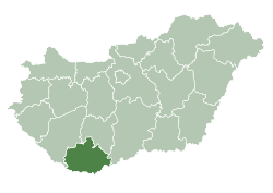
 Abaliget Location of Abaliget  Abaliget Abaliget (Hungary) | |
| Coordinates: 46.14419°N 18.11675°E | |
| Country | |
| County | Baranya |
| District | Pécs |
| Area | |
| • Total | 16.09 km2 (6.21 sq mi) |
| Population (1 Jan 2019) | |
| • Total | 647 |
| • Density | 40/km2 (100/sq mi) |
| Time zone | UTC+1 (CET) |
| • Summer (DST) | UTC+2 (CEST) |
| Postal code | 7678 |
| Area code(s) | 72 |
Its population at the 2011 Census was 607.
Geography
The village is located at 46° 8′ 39.08″ N, 18° 7′ 0.3″ E. Its area is 16.09 km2 (6.21 sq mi). It is part of the Southern Transdanubia statistical region.
Abaliget is located in the western Mecsek Mountains, and much of its land lies within the Western Mecsek Landscape Protection District, managed by the Danube-Dráva National Park. The village is located on Middle Triassic limestone karst, which has formed the sinkholes, springs, tufa, and caves that are common features in the surrounding area.[1]
Pécs is located 10 km southeast, density is 2 km northwest, Kovácsszénája 2 km north, Orfű 1 km east, Kovasiluš is 5 km south, Kővágótöttös 5 km southwest
Government
Administratively it belongs to the Pécs microregion in the Baranja district. The postal code is 7678.
Demographics
Abaliget has 637 inhabitants (2001).
Points of Interest
- Abaliget Cave (also called Paplika), an active karst cave with stalactites formed from Triassic period limestone. It has a total length of 2,000 meters across 3 branches, making it the longest cave in the Mecsek Mountains. It has been under protected status since 1982. The Danube-Dráva National Park Directorate has managed tourist access to the cave and its conservation since 1996. Visitors can go on guided tours of the main branch and the cave is also used for speleotherapy.[2][3][4]
- The Bat Museum (Denevérmúzeum), which opened in 2004 to highlight the research of local bat populations. Bat research has been ongoing in Abaliget Cave since 1923, and 19 species are known to reside there regularly, the most common being the Geoffroy's bat (M. emarginatus), lesser horseshoe bat (R. hipposideros), and greater horseshoe bat (R. ferrumequinum).[1][5][6]

Transportation
Although Abaliget is not on the railway, the 3 km distant railway station called this village is located just one kilometer from another village, Korvodje.
Sister cities
Knonau (since 1993) -Switzerland
Dannenfers (since 2002) -Germany
Sievi (since 2005) -Finland
See also
References
- "Western Mecsek Landscape Protection District". Danube-Dráva National Park Directorate (in Hungarian). Retrieved 2020-06-27.
- "The History of the Cave". Abaligeti Barlang (in Hungarian). Retrieved 2020-06-26.
- "Caves". Hungarian Nature Conservation Office. Retrieved 26 June 2020.
- "Abaliget Cave". Hungarian Nature Conservation Office (in Hungarian). Retrieved 2020-06-27.
- "Abaliget Bat Museum". Abaligeti Barlang (in Hungarian). Retrieved 2020-06-27.
- Duckeck, Jochen. "Abaligeti-barlang". www.showcaves.com. Retrieved 2020-06-27.