ADEOS I
ADEOS I (Advanced Earth Observing Satellite 1) was an Earth observation satellite[4] launched by NASDA in 1996.[5][6] The mission's Japanese name, Midori, means "green".[7]
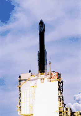 Launch of ADEOS I aboard an H-II rocket | |||||||||||||||||||
| Names | Advanced Earth Observing Satellite Midori | ||||||||||||||||||
|---|---|---|---|---|---|---|---|---|---|---|---|---|---|---|---|---|---|---|---|
| Mission type | Earth observation Environmental monitoring | ||||||||||||||||||
| Operator | NASDA | ||||||||||||||||||
| COSPAR ID | 1996-046A | ||||||||||||||||||
| SATCAT no. | 24277 | ||||||||||||||||||
| Mission duration | Final: 10 months, 13 days | ||||||||||||||||||
| Spacecraft properties | |||||||||||||||||||
| Launch mass | 3,500 kg (7,700 lb) | ||||||||||||||||||
| Dimensions | 4 × 4 × 5 m (13 × 13 × 16 ft) | ||||||||||||||||||
| Power | 5,000 watts | ||||||||||||||||||
| Start of mission | |||||||||||||||||||
| Launch date | 17 August 1996, 01:53:00 UTC[1] | ||||||||||||||||||
| Rocket | H-II | ||||||||||||||||||
| Launch site | Tanegashima Yoshinobu 1 | ||||||||||||||||||
| End of mission | |||||||||||||||||||
| Disposal | Spacecraft failure | ||||||||||||||||||
| Last contact | 30 June 1997, 07:21 UTC | ||||||||||||||||||
| Orbital parameters | |||||||||||||||||||
| Reference system | Geocentric | ||||||||||||||||||
| Regime | Sun-synchronous[2] | ||||||||||||||||||
| Eccentricity | 0.0002193 | ||||||||||||||||||
| Perigee altitude | 792 km (492 mi) | ||||||||||||||||||
| Apogee altitude | 795 km (494 mi) | ||||||||||||||||||
| Inclination | 98.7 degrees | ||||||||||||||||||
| Period | 101 minutes | ||||||||||||||||||
| Mean motion | 14.29 rev/day | ||||||||||||||||||
| Epoch | 26 December 2016, 19:33:18 UTC[3] | ||||||||||||||||||
| |||||||||||||||||||
The mission ended in July 1997 after the satellite sustained structural damage to the solar panel array.[5] Its successor, ADEOS II, was launched in 2002. Like the first mission, it ended after less than a year[7] – also following solar panel malfunctions.[8]
Purpose
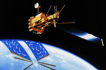
ADEOS was designed to observe Earth's environmental changes, focusing on global warming, depletion of the ozone layer, and deforestation.[7]
On board the satellite are eight instruments developed by NASDA, NASA, and CNES. The Ocean Color and Temperature Scanner (OCTS) is a whisk broom radiometer developed by NASDA.[4] The Advanced Visible and Near Infrared Radiometer (AVNIR), an optoelectronic scanning radiometer with CCD detectors, was also produced by NASDA.[4] The NASA Scatterometer (NSCAT), developed with the Jet Propulsion Laboratory, used fan-beam Doppler signals to measure wind speeds over bodies of water.[4] The Total Ozone Mapping Spectrometer (TOMS) was built by CNES to study changes to Earth's ozone layer.[4] The Polarization and Directionality of the Earth's Reflectance (POLDER) device was also developed by CNES, and was also launched on ADEOS II.[4] The Improved Limb Atmospheric Spectrometer (ILAS) was developed by NASDA and the Environment Agency of Japan, and used grating spectrometers to measure the properties of trace gases using solar occultation.[4] The Retroreflector in Space (RIS) and Interferometric Monitor for Greenhouse Gases (IMG) were both developed by Japan, and studied atmospheric trace gases and greenhouse gases respectively.[4]
Mission
Failure
On 28 August 1996, the satellite adjusted its attitude to control its orbit. As a result of this maneuver, the solar panel received sunlight from the rear. This caused the solar paddle mast to expand and the panel blanket to contract, placing tension on a soldered joint on the paddle, which eventually broke.[5]
The final communication from the satellite was received at 07:21 UTC on 30 June 1997,[5] 9 months after launch.[7]
Footnotes
- Earth Observation Research and Application Center (2005)
- Earth Observation Research and Application Center (1998)
- "ADEOS I - Orbit". Heavens Above. 27 December 2016. Retrieved 28 December 2016.
- Earth Observation Portal (2008)
- Satellite News Digest (2006)
- International Laser Ranging Service (2010)
- Darling (2010)
- Satellite News Digest (2003)
Sources
- Darling, David (2010), ADEOS (Advanced Earth Observing Satellite), Dundee: The Internet Encyclopedia of Science, retrieved 23 September 2010
- Earth Observation Portal (2008), ADEOS (Advanced Earth Observing Satellite) / Midori, Frascati, Italy: ESA Centre for Earth Observation, archived from the original on 21 July 2011, retrieved 23 September 2010
- ADEOS Project Overview (1998), Advanced Earth Observing Satellite, Chōfu, Tokyo: Japan Aerospace Exploration Agency, retrieved 23 September 2010
- Earth Observation Research and Application Center (2005), Advanced Earth Observing Satellite, Chōfu, Tokyo: Japan Aerospace Exploration Agency, retrieved 23 September 2010
- Satellite News Digest (2006), Midori I (ADEOS I), Luebeck, Germany: Sat-ND, retrieved 18 September 2010
- Satellite News Digest (2003), Midori II (ADEOS II), Luebeck, Germany: Sat-ND, retrieved 25 September 2010